 |
|
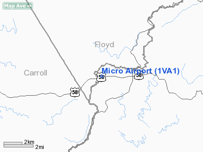
Location & QuickFacts
| FAA Information Effective: | 2008-09-25 |
| Airport Identifier: | 1VA1 |
| Airport Status: | Operational |
| Longitude/Latitude: | 080-26-55.5400W/36-44-06.8600N
-80.448761/36.735239 (Estimated) |
| Elevation: | 2923 ft / 890.93 m (Estimated) |
| Land: | 30 acres |
| From nearest city: | 10 nautical miles NW of Stuart, VA |
| Location: | Patrick County, VA |
| Magnetic Variation: | 06W (1990) |
Owner & Manager
| Ownership: | Privately owned |
| Owner: | Melvin C. Stanley |
| Address: | Rte 2, Box 796
Meadows Of Dan, VA 24120 |
| Phone number: | 703-952-2026 |
| Manager: | Melvin C. Stanley |
| Address: | Rte 2, Box 796
Meadows Of Dan, VA 24120 |
| Phone number: | 703-952-2026 |
Airport Operations and Facilities
| Airport Use: | Private |
| Wind indicator: | Yes |
| Segmented Circle: | No |
| Control Tower: | No |
| Sectional chart: | Cincinnati |
| Region: | AEA - Eastern |
| Boundary ARTCC: | ZTL - Atlanta |
| Tie-in FSS: | DCA - Leesburg |
| FSS on Airport: | No |
| FSS Toll Free: | 1-800-WX-BRIEF |
Runway Information
Runway 08/26
| Dimension: | 2950 x 100 ft / 899.2 x 30.5 m |
| Surface: | TURF, |
| |
Runway 08 |
Runway 26 |
| Longitude: | 080-27-12.7400W | 080-26-38.3300W |
| Latitude: | 36-44-02.2800N | 36-44-11.4400N |
| Elevation: | 2964.00 ft | 2902.00 ft |
| Traffic Pattern: | Left | Left |
|
Radio Navigation Aids
| ID |
Type |
Name |
Ch |
Freq |
Var |
Dist |
| OQA | FAN MARKER | Rockingham County | | | | 35.2 nm |
| HLX | NDB | Hillsville | | 269.00 | 06W | 18.0 nm |
| AZW | NDB | Mount Airy | | 223.00 | 07W | 21.7 nm |
| UV | NDB | Bales | | 396.00 | 07W | 27.1 nm |
| TEC | NDB | Tech | | 368.00 | 06W | 28.5 nm |
| ZEF | NDB | Zephyr | | 326.00 | 05W | 28.6 nm |
| CNQ | NDB | Callahan | | 379.00 | 05W | 34.6 nm |
| VIT | NDB | Vinton | | 277.00 | 06W | 39.2 nm |
| SIF | NDB | Slammer | | 423.00 | 07W | 39.3 nm |
| MK | NDB | Suzze | | 335.00 | 06W | 39.8 nm |
| JU | NDB | Ashee | | 410.00 | 07W | 45.9 nm |
| UKF | NDB | Wilki | | 209.00 | 06W | 48.8 nm |
| DVZ | NDB | Davie | | 354.00 | 06W | 49.4 nm |
| ODR | VOR | Woodrum | | 114.90 | 06W | 42.0 nm |
| PSK | VORTAC | Pulaski | 115X | 116.80 | 06W | 24.7 nm |
| ROA | VORTAC | Roanoke | 031X | 109.40 | 04W | 40.8 nm |
| GSO | VORTAC | Greensboro | 109X | 116.20 | 03W | 47.3 nm |
| BLF | VORTAC | Bluefield | 037X | 110.00 | 03W | 49.6 nm |
Remarks
- PRVDD ALL OPNS BE CONDUCTED IN DALGT VFR CONDS.
Images and information placed above are from
http://www.airport-data.com/airport/1VA1/
We thank them for the data!
| General Info
|
| Country |
United States
|
| State |
VIRGINIA
|
| FAA ID |
1VA1
|
| Latitude |
36-44-07.490N
|
| Longitude |
080-26-57.234W
|
| Elevation |
2950 feet
|
| Near City |
STUART
|
We don't guarantee the information is fresh and accurate. The data may
be wrong or outdated.
For more up-to-date information please refer to other sources.
|
|


