 |
|
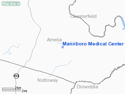
Mannboro Medical Center Heliport |
Location & QuickFacts
| FAA Information Effective: | 2008-09-25 |
| Airport Identifier: | 63VA |
| Airport Status: | Operational |
| Longitude/Latitude: | 077-49-16.9950W/37-15-03.5410N
-77.821388/37.250984 (Estimated) |
| Elevation: | 320 ft / 97.54 m (Estimated) |
| Land: | 1 acres |
| From nearest city: | 2 nautical miles E of Mannboro, VA |
| Location: | Amelia County, VA |
| Magnetic Variation: | 09W (1990) |
Owner & Manager
| Ownership: | Privately owned |
| Owner: | Southern Dominion Health System Inc |
| Address: |
Victoria, VA 23974 |
| Phone number: | 434-696-2165 |
| Manager: | Charlene Robins, Dir. Of Operations |
| Address: | 1508 K-v Road, Po Box 70
Victoria, VA 23974 |
| Phone number: | 434-696-2165 |
Airport Operations and Facilities
| Airport Use: | Private
MEDICAL USE. |
| Wind indicator: | Yes |
| Segmented Circle: | No |
| Control Tower: | No |
| Sectional chart: | Washington |
| Region: | AEA - Eastern |
| Boundary ARTCC: | ZDC - Washington |
| Tie-in FSS: | DCA - Leesburg |
| FSS on Airport: | No |
| FSS Toll Free: | 1-800-WX-BRIEF |
Runway Information
Helipad H1
| Dimension: | 30 x 30 ft / 9.1 x 9.1 m |
| Surface: | CONC, |
| |
Runway H1 |
Runway |
| Traffic Pattern: | Left | Left |
| Markings: | Basic, | , |
|
Radio Navigation Aids
| ID |
Type |
Name |
Ch |
Freq |
Var |
Dist |
| BKT | NDB | Blackstone | | 326.00 | 09W | 13.0 nm |
| PTB | NDB | Petersburg | | 284.00 | 08W | 13.9 nm |
| CF | NDB | Pubbs | | 392.00 | 09W | 18.3 nm |
| FVX | NDB | Farmville | | 367.00 | 07W | 30.1 nm |
| LJK | NDB | Ashey | | 280.00 | 09W | 35.4 nm |
| MBV | NDB | Mecklenburg/dcmsnd | | 356.00 | 08W | 35.4 nm |
| AEA | NDB | Jones | | 373.00 | 09W | 39.8 nm |
| AKQ | NDB | Wakefield | | 274.00 | 09W | 42.5 nm |
| ELQ | NDB | Emporia | | 261.00 | 10W | 42.5 nm |
| IQK | NDB | Louisa | | 382.00 | 09W | 46.3 nm |
| RZZ | NDB | Rapids | | 407.00 | 08W | 49.0 nm |
| FAK | VORTAC | Flat Rock | 080X | 113.30 | 06W | 16.7 nm |
| LVL | VORTAC | Lawrenceville | 076X | 112.90 | 08W | 26.3 nm |
| RIC | VORTAC | Richmond | 088X | 114.10 | 09W | 28.3 nm |
| HPW | VORTAC | Hopewell | 057X | 112.00 | 06W | 34.1 nm |
| GVE | VORTAC | Gordonsville | 103X | 115.60 | 06W | 48.5 nm |
Remarks
- PRVDD THAT HELIPORT IS USED FOR VFR DALGT OPNS ONLY UNTIL SUCH TIME THAT LGTS ARE INSTALLED.
Images and information placed above are from
http://www.airport-data.com/airport/63VA/
We thank them for the data!
| General Info
|
| Country |
United States
|
| State |
VIRGINIA
|
| FAA ID |
63VA
|
| Latitude |
37-15-03.541N
|
| Longitude |
077-49-16.995W
|
| Elevation |
320 feet
|
| Near City |
MANNBORO
|
We don't guarantee the information is fresh and accurate. The data may
be wrong or outdated.
For more up-to-date information please refer to other sources.
|
|


