 |
|
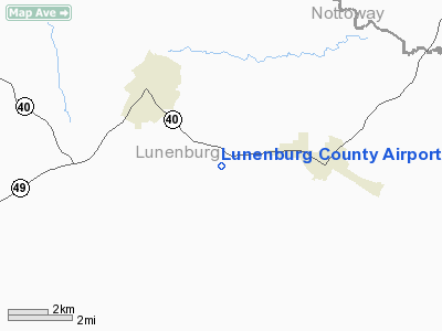
Location & QuickFacts
| FAA Information Effective: | 2008-09-25 |
| Airport Identifier: | W31 |
| Airport Status: | Operational |
| Longitude/Latitude: | 078-11-05.9950W/36-57-36.5400N
-78.184999/36.960150 (Estimated) |
| Elevation: | 526 ft / 160.32 m (Surveyed) |
| Land: | 137 acres |
| From nearest city: | 3 nautical miles W of Kenbridge, VA |
| Location: | Lunenburg County, VA |
| Magnetic Variation: | 08W (1985) |
Owner & Manager
| Ownership: | Publicly owned |
| Owner: | Lunenburg County |
| Address: | Courthouse Square
Lunenburg, VA 23952 |
| Phone number: | 434-696-2142 |
| Manager: | Michael Cocker |
| Address: | P. O. Box 1041
Victoria, VA 23974 |
| Phone number: | 434-391-1080 |
Airport Operations and Facilities
| Airport Use: | Open to public |
| Wind indicator: | Yes |
| Segmented Circle: | No |
| Control Tower: | No |
| Lighting Schedule: | DUSK-DAWN |
| Beacon Color: | Clear-Green (lighted land airport) |
| Landing fee charge: | No |
| Sectional chart: | Washington |
| Region: | AEA - Eastern |
| Boundary ARTCC: | ZDC - Washington |
| Tie-in FSS: | DCA - Leesburg |
| FSS on Airport: | No |
| FSS Toll Free: | 1-800-WX-BRIEF |
| NOTAMs Facility: | DCA (NOTAM-d service avaliable) |
| Federal Agreements: | Y1 |
Airport Communications
| CTAF: | 122.700 |
| Unicom: | 122.700 |
Airport Services
| Fuel available: | 100LL
FOR FUEL CALL 804-676-8231. |
| Airframe Repair: | NONE |
| Power Plant Repair: | NONE |
| Bottled Oxygen: | NONE |
| Bulk Oxygen: | NONE |
Runway Information
Runway 02/20
| Dimension: | 3000 x 50 ft / 914.4 x 15.2 m |
| Surface: | ASPH, Good Condition |
| Surface Treatment: | Aggregate Friction Seal Coat |
| Weight Limit: | Single wheel: 12500 lbs. |
| Edge Lights: | Low |
| |
Runway 02 |
Runway 20 |
| Traffic Pattern: | Left | Left |
| Markings: | Basic, Good Condition | Basic, Good Condition |
| Crossing Height: | 26.00 ft | 26.00 ft |
| VASI: | system of panels on left side that may or may not be lighted | system of panels on left side that may or may not be lighted |
| Visual Glide Angle: | 5.00° | 5.00° |
| Obstruction: | 19 ft tree, 385.0 ft from runway, 7 ft right of centerline, 10:1 slope to clear
NUMEROUS SMALL PINES LOCATED APPROXIMATELY 135 FEET OFF THE END OF THE RUNWAY, THE LARGEST OF WHICH IS 18 FEET ABOVE THE RUNWAY END AND 95 FEET RIGHT ON APPROACH. | 47 ft tree, 405.0 ft from runway, 140 ft right of centerline, 4:1 slope to clear |
|
Radio Navigation Aids
| ID |
Type |
Name |
Ch |
Freq |
Var |
Dist |
| BKT | NDB | Blackstone | | 326.00 | 09W | 12.1 nm |
| MBV | NDB | Mecklenburg/dcmsnd | | 356.00 | 08W | 17.2 nm |
| AEA | NDB | Jones | | 373.00 | 09W | 21.7 nm |
| FVX | NDB | Farmville | | 367.00 | 07W | 26.5 nm |
| PTB | NDB | Petersburg | | 284.00 | 08W | 31.0 nm |
| RZZ | NDB | Rapids | | 407.00 | 08W | 38.7 nm |
| CF | NDB | Pubbs | | 392.00 | 09W | 41.6 nm |
| ELQ | NDB | Emporia | | 261.00 | 10W | 42.0 nm |
| HXO | NDB | Huntsboro | | 271.00 | 07W | 44.8 nm |
| LVL | VORTAC | Lawrenceville | 076X | 112.90 | 08W | 16.0 nm |
| FAK | VORTAC | Flat Rock | 080X | 113.30 | 06W | 38.2 nm |
| SBV | VORTAC | South Boston | 041X | 110.40 | 05W | 43.4 nm |
Remarks
Images and information placed above are from
http://www.airport-data.com/airport/W31/
We thank them for the data!
| General Info
|
| Country |
United States
|
| State |
VIRGINIA
|
| FAA ID |
W31
|
| Latitude |
36-57-36.540N
|
| Longitude |
078-11-05.995W
|
| Elevation |
526 feet
|
| Near City |
KENBRIDGE
|
We don't guarantee the information is fresh and accurate. The data may
be wrong or outdated.
For more up-to-date information please refer to other sources.
|
|


