 |
|
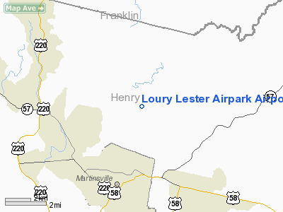
Loury Lester Airpark Airport |
Location & QuickFacts
| FAA Information Effective: | 2008-09-25 |
| Airport Identifier: | 6VA2 |
| Airport Status: | Operational |
| Longitude/Latitude: | 079-50-52.1350W/36-44-30.4930N
-79.847815/36.741804 (Estimated) |
| Elevation: | 1030 ft / 313.94 m (Surveyed) |
| Land: | 0 acres |
| From nearest city: | 3 nautical miles NE of Martinsville, VA |
| Location: | Henry County, VA |
| Magnetic Variation: | 06W (1985) |
Owner & Manager
| Ownership: | Privately owned |
| Owner: | Loury Lester Airpark Inc. |
| Address: | Po Box 3110
Martinsville, VA 24112 |
| Phone number: | 703-632-6849 |
| Manager: | H. Arnold Prillaman |
| Address: | Po Box 3110
Martinsville, VA 24115 |
| Phone number: | 703-632-6849 |
Airport Operations and Facilities
| Airport Use: | Private |
| Wind indicator: | No |
| Segmented Circle: | No |
| Control Tower: | No |
| Landing fee charge: | No |
| Sectional chart: | Cincinnati |
| Region: | AEA - Eastern |
| Boundary ARTCC: | ZDC - Washington |
| Tie-in FSS: | DCA - Leesburg |
| FSS on Airport: | No |
| FSS Toll Free: | 1-800-WX-BRIEF |
Runway Information
Runway 15/33
| Dimension: | 4000 x 100 ft / 1219.2 x 30.5 m |
| Surface: | TURF, |
| |
Runway 15 |
Runway 33 |
| Traffic Pattern: | Left | Left |
|
Radio Navigation Aids
| ID |
Type |
Name |
Ch |
Freq |
Var |
Dist |
| OQA | FAN MARKER | Rockingham County | | | | 19.0 nm |
| UV | NDB | Bales | | 396.00 | 07W | 9.7 nm |
| SIF | NDB | Slammer | | 423.00 | 07W | 22.0 nm |
| VIT | NDB | Vinton | | 277.00 | 06W | 27.8 nm |
| CNQ | NDB | Callahan | | 379.00 | 05W | 34.6 nm |
| TEC | NDB | Tech | | 368.00 | 06W | 38.7 nm |
| AZW | NDB | Mount Airy | | 223.00 | 07W | 39.8 nm |
| LY | NDB | Bojar | | 385.00 | 08W | 42.7 nm |
| HLX | NDB | Hillsville | | 269.00 | 06W | 46.9 nm |
| HB | NDB | Himun | | 361.00 | 08W | 47.6 nm |
| HUR | NDB | Person | | 220.00 | 08W | 48.6 nm |
| ZEF | NDB | Zephyr | | 326.00 | 05W | 49.5 nm |
| DAN | VOR | Danville | | 113.10 | 06W | 26.8 nm |
| ODR | VOR | Woodrum | | 114.90 | 06W | 35.6 nm |
| ROA | VORTAC | Roanoke | 031X | 109.40 | 04W | 37.7 nm |
| SBV | VORTAC | South Boston | 041X | 110.40 | 05W | 40.4 nm |
| GSO | VORTAC | Greensboro | 109X | 116.20 | 03W | 42.3 nm |
| LYH | VORTAC | Lynchburg | 029X | 109.20 | 05W | 42.6 nm |
| PSK | VORTAC | Pulaski | 115X | 116.80 | 06W | 46.5 nm |
Images and information placed above are from
http://www.airport-data.com/airport/6VA2/
We thank them for the data!
| General Info
|
| Country |
United States
|
| State |
VIRGINIA
|
| FAA ID |
6VA2
|
| Latitude |
36-44-30.493N
|
| Longitude |
079-50-52.135W
|
| Elevation |
1030 feet
|
| Near City |
MARTINSVILLE
|
We don't guarantee the information is fresh and accurate. The data may
be wrong or outdated.
For more up-to-date information please refer to other sources.
|
|


