 |
|
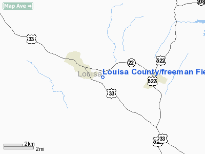
Louisa County/freeman Field Airport |
Louisa County Airport
Freeman Field |
| IATA: LOW – ICAO: KLKU – FAA LID: LKU |
| Summary |
| Airport type |
Public |
| Owner |
Industrial Development Authority of Louisa Co. |
| Location |
Louisa, Virginia |
| Elevation AMSL |
493 ft / 150 m |
| Coordinates |
38°00′35″N 077°58′12″W / 38.00972°N 77.97°W / 38.00972; -77.97 |
| Runways |
| Direction |
Length |
Surface |
| ft |
m |
| 9/27 |
4,301 |
1,311 |
Asphalt |
| Statistics (2008) |
| Aircraft operations |
20,987 |
| Source: Federal Aviation Administration |
Louisa County Airport (IATA: LOW, ICAO: KLKU, FAA LID: LKU), also known as Freeman Field, is a public use airport located two nautical miles (4 km) southeast of the central business district of Louisa, a town in Louisa County, Virginia, United States.
Although most U.S. airports use the same three-letter location identifier for the FAA and IATA, this airport is assigned LKU by the FAA and LOW by the IATA.
Facilities and aircraft
Louisa County Airport covers an area of 171 acres (69 ha) at an elevation of 493 feet (150 m) above mean sea level. It has one asphalt paved runway designated 9/27 which measures 4,301 by 100 feet (1,311 x 30 m). For the 12-month period ending May 30, 2008, the airport had 20,987 aircraft operations, an average of 57 per day: 96% general aviation, 2% air taxi and 2% military.
The above content comes from Wikipedia and is published under free licenses – click here to read more.
Location & QuickFacts
| FAA Information Effective: | 2008-09-25 |
| Airport Identifier: | LKU |
| Airport Status: | Operational |
| Longitude/Latitude: | 077-58-12.5000W/38-00-35.4000N
-77.970139/38.009833 (Estimated) |
| Elevation: | 493 ft / 150.27 m (Estimated) |
| Land: | 171 acres |
| From nearest city: | 2 nautical miles SE of Louisa, VA |
| Location: | Louisa County, VA |
| Magnetic Variation: | 09W (1995) |
Owner & Manager
| Ownership: | Publicly owned |
| Owner: | Ind Dev Auth Of Louisa Co. |
| Address: | Po Box 27
Louisa, VA 23093 |
| Phone number: | 540-967-0050 |
| Manager: | Dawn Howard |
| Address: | 335 Industrial Drive, P.o. Box 27
Louisa, VA 23093 |
| Phone number: | 540-967-0050
OR CONTACT FBO AT 540-967-5380. |
Airport Operations and Facilities
| Airport Use: | Open to public |
| Wind indicator: | Yes |
| Segmented Circle: | Yes |
| Control Tower: | No |
| Lighting Schedule: | DUSK-DAWN
MIRL RY 09/27 PRESET LOW INTST; TO INCR INTST & ACTVT REIL RYS 09 & 27 - CTAF. |
| Beacon Color: | Clear-Green (lighted land airport) |
| Sectional chart: | Washington |
| Region: | AEA - Eastern |
| Boundary ARTCC: | ZDC - Washington |
| Tie-in FSS: | DCA - Leesburg |
| FSS Toll Free: | 1-800-WX-BRIEF |
| NOTAMs Facility: | LKU (NOTAM-d service avaliable) |
| Federal Agreements: | NGY |
Airport Communications
| CTAF: | 122.725 |
| Unicom: | 122.725 |
Airport Services
| Fuel available: | 100LLA |
| Airframe Repair: | MAJOR |
| Power Plant Repair: | MAJOR |
Runway Information
Runway 09/27
| Dimension: | 4301 x 100 ft / 1310.9 x 30.5 m |
| Surface: | ASPH, Good Condition |
| Weight Limit: | Single wheel: 12500 lbs. |
| Edge Lights: | Medium |
| |
Runway 09 |
Runway 27 |
| Longitude: | 077-58-39.0894W | 077-57-45.8334W |
| Latitude: | 38-00-32.5336N | 38-00-38.2069N |
| Elevation: | 469.00 ft | 493.00 ft |
| Alignment: | 82 | 127 |
| ILS Type: | | LOCALIZER
|
| Traffic Pattern: | Right | Left |
| Markings: | Non-precision instrument, Good Condition | Non-precision instrument, Good Condition |
| Crossing Height: | 40.00 ft | 40.00 ft |
| VASI: | 2-light PAPI on left side | 2-light PAPI on left side |
| Visual Glide Angle: | 3.00° | 3.00° |
| Runway End Identifier: | Yes | Yes |
| Obstruction: | 20 ft tree, 591.0 ft from runway, 172 ft right of centerline, 20:1 slope to clear | 23 ft tree, 892.0 ft from runway, 138 ft right of centerline, 30:1 slope to clear |
|
Radio Navigation Aids
| ID |
Type |
Name |
Ch |
Freq |
Var |
Dist |
| IQK | NDB | Louisa | | 382.00 | 09W | 5.3 nm |
| AZS | NDB | Azalea Park | | 336.00 | 08W | 26.0 nm |
| MSQ | NDB | Nailr | | 351.00 | 10W | 26.9 nm |
| LJK | NDB | Ashey | | 280.00 | 09W | 27.3 nm |
| EZF | NDB | Shannon | | 237.00 | 10W | 29.0 nm |
| APH | NDB | A P Hill | | 396.00 | 10W | 30.9 nm |
| CJR | NDB | Culpeper | | 252.00 | 09W | 31.8 nm |
| FVX | NDB | Farmville | | 367.00 | 07W | 45.3 nm |
| CF | NDB | Pubbs | | 392.00 | 09W | 47.5 nm |
| LUA | NDB | Caverns | | 245.00 | 09W | 47.7 nm |
| GVE | VORTAC | Gordonsville | 103X | 115.60 | 06W | 8.7 nm |
| FAK | VORTAC | Flat Rock | 080X | 113.30 | 06W | 29.7 nm |
| BRV | VORTAC | Brooke | 092X | 114.50 | 09W | 35.2 nm |
| CSN | VORTAC | Casanova | 110X | 116.30 | 06W | 38.3 nm |
| RIC | VORTAC | Richmond | 088X | 114.10 | 09W | 43.4 nm |
Remarks
- BCN LOCATED ON WATER TWR; NORTH SIDE APCH RY 27.
- DEER ON AND INVOF ARPT.
Images and information placed above are from
http://www.airport-data.com/airport/LKU/
We thank them for the data!
| General Info
|
| Country |
United States
|
| State |
VIRGINIA
|
| FAA ID |
LKU
|
| Latitude |
38-00-35.400N
|
| Longitude |
077-58-12.500W
|
| Elevation |
493 feet
|
| Near City |
LOUISA
|
We don't guarantee the information is fresh and accurate. The data may
be wrong or outdated.
For more up-to-date information please refer to other sources.
|
|


