 |
|
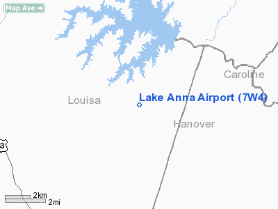
Location & QuickFacts
| FAA Information Effective: | 2008-09-25 |
| Airport Identifier: | 7W4 |
| Airport Status: | Operational |
| Longitude/Latitude: | 077-44-44.9690W/37-57-56.5030N
-77.745825/37.965695 (Estimated) |
| Elevation: | 355 ft / 108.20 m (Surveyed) |
| Land: | 134 acres |
| From nearest city: | 0 nautical miles NW of Bumpass, VA |
| Location: | Louisa County, VA |
| Magnetic Variation: | 09W (1985) |
Owner & Manager
| Ownership: | Privately owned |
| Owner: | Mile High Charters, Llc |
| Address: | 10267 Matthews Grove Ln.
Mechanicsville, VA 23116 |
| Phone number: | 804-550-5794 |
| Manager: | Richard Henry Rempe |
| Address: | 10267 Matthews Grove Ln.
Mechanicsville, VA 23116 |
| Phone number: | 804-550-5794
EMERGENCY PHONE NUMBER IS: (804) 514-6642 |
Airport Operations and Facilities
| Airport Use: | Open to public |
| Wind indicator: | No |
| Segmented Circle: | No |
| Control Tower: | No |
| Lighting Schedule: | DUSK-DAWN |
| Beacon Color: | Clear-Green (lighted land airport) |
| Landing fee charge: | No |
| Sectional chart: | Washington |
| Region: | AEA - Eastern |
| Boundary ARTCC: | ZDC - Washington |
| Tie-in FSS: | DCA - Leesburg |
| FSS on Airport: | No |
| FSS Toll Free: | 1-800-WX-BRIEF |
| NOTAMs Facility: | DCA (NOTAM-d service avaliable) |
Airport Communications
Airport Services
| Airframe Repair: | NONE |
| Power Plant Repair: | NONE |
| Bottled Oxygen: | NONE |
| Bulk Oxygen: | NONE |
Runway Information
Runway 08/26
| Dimension: | 2560 x 25 ft / 780.3 x 7.6 m |
| Surface: | ASPH, Fair Condition |
| Weight Limit: | Single wheel: 6000 lbs. |
| Edge Lights: | Low |
| |
Runway 08 |
Runway 26 |
| Traffic Pattern: | Left | Left |
| Markings: | Basic, Fair Condition | Basic, Good Condition |
| Obstruction: | 42 ft trees, 200.0 ft from runway, 122 ft left of centerline
TREES 100 FT FM CTRLN NORTH AND SOUTH OF RY. | 43 ft trees, 235.0 ft from runway, 125 ft right of centerline |
|
Radio Navigation Aids
| ID |
Type |
Name |
Ch |
Freq |
Var |
Dist |
| IQK | NDB | Louisa | | 382.00 | 09W | 6.3 nm |
| LJK | NDB | Ashey | | 280.00 | 09W | 17.1 nm |
| APH | NDB | A P Hill | | 396.00 | 10W | 21.2 nm |
| EZF | NDB | Shannon | | 237.00 | 10W | 22.8 nm |
| MSQ | NDB | Nailr | | 351.00 | 10W | 30.3 nm |
| CJR | NDB | Culpeper | | 252.00 | 09W | 34.4 nm |
| AZS | NDB | Azalea Park | | 336.00 | 08W | 36.7 nm |
| CF | NDB | Pubbs | | 392.00 | 09W | 40.5 nm |
| FVX | NDB | Farmville | | 367.00 | 07W | 49.4 nm |
| GVE | VORTAC | Gordonsville | 103X | 115.60 | 06W | 19.5 nm |
| FAK | VORTAC | Flat Rock | 080X | 113.30 | 06W | 26.6 nm |
| BRV | VORTAC | Brooke | 092X | 114.50 | 09W | 29.0 nm |
| RIC | VORTAC | Richmond | 088X | 114.10 | 09W | 34.4 nm |
| CSN | VORTAC | Casanova | 110X | 116.30 | 06W | 41.0 nm |
| HPW | VORTAC | Hopewell | 057X | 112.00 | 06W | 48.6 nm |
Remarks
Images and information placed above are from
http://www.airport-data.com/airport/7W4/
We thank them for the data!
| General Info
|
| Country |
United States
|
| State |
VIRGINIA
|
| FAA ID |
7W4
|
| Latitude |
37-57-56.503N
|
| Longitude |
077-44-44.969W
|
| Elevation |
355 feet
|
| Near City |
BUMPASS
|
We don't guarantee the information is fresh and accurate. The data may
be wrong or outdated.
For more up-to-date information please refer to other sources.
|
|


