 |
|
Location & QuickFacts
| FAA Information Effective: | 2008-09-25 |
| Airport Identifier: | 50VA |
| Airport Status: | Operational |
| Longitude/Latitude: | 079-10-21.0890W/37-25-02.5110N
-79.172525/37.417364 (Estimated) |
| Elevation: | 700 ft / 213.36 m (Estimated) |
| Land: | 25 acres |
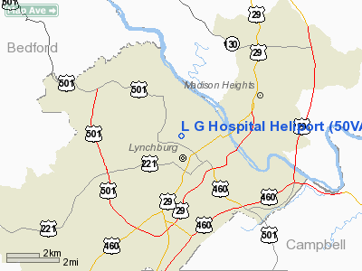
| From nearest city: | 2 nautical miles E of Lynchburg, VA |
| Location: | Lynchburg County, VA |
| Magnetic Variation: | 07W (1985) |
Owner & Manager
| Ownership: | Privately owned |
| Owner: | Lynchburg General Hospital |
| Address: | Tate Springs Road
Lynchburg, VA 24506 |
| Phone number: | 804-947-3000 |
| Manager: | W. Scott Burnette |
| Address: | Tate Springs Road
Lynchburg, VA 24506 |
| Phone number: | 804-947-3100 |
Airport Operations and Facilities
| Airport Use: | Private
MEDICAL USE. |
| Wind indicator: | Yes |
| Segmented Circle: | No |
| Control Tower: | No |
| Landing fee charge: | No |
| Sectional chart: | Cincinnati |
| Region: | AEA - Eastern |
| Boundary ARTCC: | ZDC - Washington |
| Tie-in FSS: | DCA - Leesburg |
| FSS on Airport: | No |
| FSS Toll Free: | 1-800-WX-BRIEF |
Runway Information
Helipad H1
| Dimension: | 40 x 40 ft / 12.2 x 12.2 m |
| Surface: | CONC, |
| |
Runway H1 |
Runway |
| Traffic Pattern: | Left | Left |
|
Radio Navigation Aids
| ID |
Type |
Name |
Ch |
Freq |
Var |
Dist |
| LY | NDB | Bojar | | 385.00 | 08W | 9.9 nm |
| FVX | NDB | Farmville | | 367.00 | 07W | 35.3 nm |
| VIT | NDB | Vinton | | 277.00 | 06W | 36.2 nm |
| AZS | NDB | Azalea Park | | 336.00 | 08W | 47.3 nm |
| CNQ | NDB | Callahan | | 379.00 | 05W | 48.0 nm |
| ODR | VOR | Woodrum | | 114.90 | 06W | 38.9 nm |
| MOL | VOR/DME | Montebello | 100X | 115.30 | 05W | 29.2 nm |
| LYH | VORTAC | Lynchburg | 029X | 109.20 | 05W | 10.2 nm |
| ROA | VORTAC | Roanoke | 031X | 109.40 | 04W | 43.1 nm |
| SBV | VORTAC | South Boston | 041X | 110.40 | 05W | 45.3 nm |
Remarks
- LIMITED TO MEDICAL FLIGHTS ONLY;SECURITY IS PROVIDED DURING OPERATIONS.
Images and information placed above are from
http://www.airport-data.com/airport/50VA/
We thank them for the data!
| General Info
|
| Country |
United States
|
| State |
VIRGINIA
|
| FAA ID |
50VA
|
| Latitude |
37-25-02.511N
|
| Longitude |
079-10-21.089W
|
| Elevation |
700 feet
|
| Near City |
LYNCHBURG
|
We don't guarantee the information is fresh and accurate. The data may
be wrong or outdated.
For more up-to-date information please refer to other sources.
|
|


