 |
|
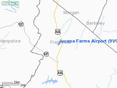
Location & QuickFacts
| FAA Information Effective: | 2008-09-25 |
| Airport Identifier: | 9VG9 |
| Airport Status: | Operational |
| Longitude/Latitude: | 078-18-16.0200W/39-22-19.6200N
-78.304450/39.372117 (Estimated) |
| Elevation: | 1160 ft / 353.57 m () |
| Land: | 10 acres |
| From nearest city: | 0 nautical miles N of Winchester, VA |
| Location: | Frederick County, VA |
| Magnetic Variation: | 10W (2000) |
Owner & Manager
| Ownership: | Privately owned |
| Owner: | Larry T. Omps |
| Address: | 171 Omps Drive
Winchester, VA 22601 |
| Phone number: | 540-662-6633 |
| Manager: | Larry T. Omps |
| Address: | 171 Omps Drive
Winchester, VA 22601 |
| Phone number: | 540-662-6633 |
Airport Operations and Facilities
| Airport Use: | Private |
| Wind indicator: | Yes |
| Segmented Circle: | No |
| Control Tower: | No |
| Sectional chart: | Washington |
| Region: | AEA - Eastern |
| Boundary ARTCC: | ZDC - Washington |
| Tie-in FSS: | DCA - Leesburg |
| FSS Toll Free: | 1-800-WX-BRIEF |
Runway Information
Runway 16/34
| Dimension: | 1500 x 70 ft / 457.2 x 21.3 m |
| Surface: | TURF, |
| |
Runway 16 |
Runway 34 |
| Traffic Pattern: | Left | Left |
| Obstruction: | 8 ft fence, 35.0 ft from runway | 100 ft trees, 500.0 ft from runway |
|
Radio Navigation Aids
| ID |
Type |
Name |
Ch |
Freq |
Var |
Dist |
| TZ | NDB | Cogan | | 364.00 | 10W | 20.4 nm |
| CBE | NDB | Cumberland | | 317.00 | 07W | 26.4 nm |
| GDX | NDB | Goodwin Lake | | 227.00 | 08W | 33.4 nm |
| LUA | NDB | Caverns | | 245.00 | 09W | 41.2 nm |
| HGR | VOR | Hagerstown | | 109.80 | 07W | 28.6 nm |
| FDK | VOR | Frederick | | 109.00 | 08W | 43.2 nm |
| ESL | VOR/DME | Kessel | 045X | 110.80 | 06W | 33.1 nm |
| GRV | VOR/DME | Grantsville | 070X | 112.30 | 06W | 38.0 nm |
| MRB | VORTAC | Martinsburg | 058X | 112.10 | 07W | 21.2 nm |
| LDN | VORTAC | Linden | 090X | 114.30 | 06W | 31.5 nm |
| THS | VORTAC | St Thomas | 097X | 115.00 | 07W | 37.5 nm |
| AML | VORTAC | Armel | 082X | 113.50 | 08W | 47.1 nm |
| CSN | VORTAC | Casanova | 110X | 116.30 | 06W | 48.5 nm |
Remarks
- PRVDD VFR ONLY, CLEAR 20:1 APCH, DEP PATH, CORRDINATE TKOFS/LDGS WITH MILITARY PERSONNEL AT ANG UNIT & OTHER PVT ARPTS, DSPLCD THLD FOR TKOFS & STOP SIGH AT OPPOSITE RY END NEAR HANGAR.
Images and information placed above are from
http://www.airport-data.com/airport/9VG9/
We thank them for the data!
| General Info
|
| Country |
United States
|
| State |
VIRGINIA
|
| FAA ID |
9VG9
|
| Latitude |
39-22-19.620N
|
| Longitude |
078-18-16.020W
|
| Elevation |
1160 feet
|
| Near City |
WINCHESTER
|
We don't guarantee the information is fresh and accurate. The data may
be wrong or outdated.
For more up-to-date information please refer to other sources.
|
|


