 |
|
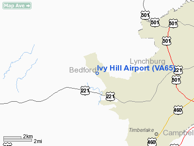
Location & QuickFacts
| FAA Information Effective: | 2008-09-25 |
| Airport Identifier: | VA65 |
| Airport Status: | Operational |
| Longitude/Latitude: | 079-19-29.1010W/37-23-40.5080N
-79.324750/37.394586 (Estimated) |
| Elevation: | 920 ft / 280.42 m (Estimated) |
| Land: | 0 acres |
| From nearest city: | 9 nautical miles W of Lynchburg, VA |
| Location: | Bedford County, VA |
| Magnetic Variation: | 07W (1985) |
Owner & Manager
| Ownership: | Privately owned |
| Owner: | Allen W. Harvey |
| Address: | Ivy Hill
Forest, VA 24551 |
| Phone number: | 434-525-2641 |
| Address: |
|
Airport Operations and Facilities
| Airport Use: | Private |
| Wind indicator: | Yes |
| Segmented Circle: | No |
| Control Tower: | No |
| Landing fee charge: | No |
| Sectional chart: | Cincinnati |
| Region: | AEA - Eastern |
| Boundary ARTCC: | ZDC - Washington |
| Tie-in FSS: | DCA - Leesburg |
| FSS on Airport: | No |
| FSS Toll Free: | 1-800-WX-BRIEF |
Airport Services
| Airframe Repair: | NONE |
| Power Plant Repair: | NONE |
Runway Information
Runway 09/27
| Dimension: | 1250 x 175 ft / 381.0 x 53.3 m |
| Surface: | TURF, |
| |
Runway 09 |
Runway 27 |
| Traffic Pattern: | Left | Left |
|
Radio Navigation Aids
| ID |
Type |
Name |
Ch |
Freq |
Var |
Dist |
| LY | NDB | Bojar | | 385.00 | 08W | 8.8 nm |
| VIT | NDB | Vinton | | 277.00 | 06W | 29.0 nm |
| CNQ | NDB | Callahan | | 379.00 | 05W | 40.6 nm |
| FVX | NDB | Farmville | | 367.00 | 07W | 42.4 nm |
| ODR | VOR | Woodrum | | 114.90 | 06W | 31.5 nm |
| DAN | VOR | Danville | | 113.10 | 06W | 49.6 nm |
| MOL | VOR/DME | Montebello | 100X | 115.30 | 05W | 32.1 nm |
| LYH | VORTAC | Lynchburg | 029X | 109.20 | 05W | 9.4 nm |
| ROA | VORTAC | Roanoke | 031X | 109.40 | 04W | 35.8 nm |
| SBV | VORTAC | South Boston | 041X | 110.40 | 05W | 45.7 nm |
Remarks
- PRIVATE USE, GOLF COURSE HOUSING DEVELOPMENT, SMALL ACFT ONLY.
- LAND OVER SMALL LAKE/UP HILL/. TREES AND WIRES 250 FT FM END. LAND RWY 27/TAKEOFF RWY 09.
Images and information placed above are from
http://www.airport-data.com/airport/VA65/
We thank them for the data!
| General Info
|
| Country |
United States
|
| State |
VIRGINIA
|
| FAA ID |
VA65
|
| Latitude |
37-23-40.508N
|
| Longitude |
079-19-29.101W
|
| Elevation |
920 feet
|
| Near City |
LYNCHBURG
|
We don't guarantee the information is fresh and accurate. The data may
be wrong or outdated.
For more up-to-date information please refer to other sources.
|
|


