 |
|
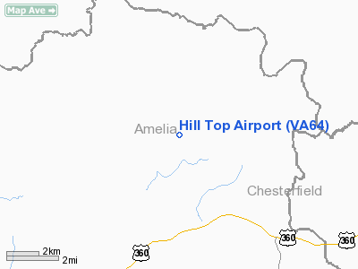
Location & QuickFacts
| FAA Information Effective: | 2008-09-25 |
| Airport Identifier: | VA64 |
| Airport Status: | Operational |
| Longitude/Latitude: | 077-57-14.0050W/37-24-57.5390N
-77.953890/37.415983 (Estimated) |
| Elevation: | 254 ft / 77.42 m (Surveyed) |
| Land: | 8 acres |
| From nearest city: | 5 nautical miles NE of Amelia, VA |
| Location: | Amelia County, VA |
| Magnetic Variation: | 08W (1985) |
Owner & Manager
| Ownership: | Privately owned |
| Owner: | Garland C. Moyer |
| Address: | Rt 4 Box 43
Amelia, VA 23002 |
| Phone number: | 804-561-2520 |
| Manager: | Garland C. Moyer |
| Address: | Rt 4 Box 43
Amelia, VA 23002 |
| Phone number: | 804-561-2520 |
Airport Operations and Facilities
| Airport Use: | Private |
| Wind indicator: | Yes |
| Segmented Circle: | No |
| Control Tower: | No |
| Landing fee charge: | No |
| Sectional chart: | Washington |
| Region: | AEA - Eastern |
| Boundary ARTCC: | ZDC - Washington |
| Tie-in FSS: | DCA - Leesburg |
| FSS on Airport: | No |
| FSS Toll Free: | 1-800-WX-BRIEF |
| NOTAMs Facility: | (NOTAM-d service avaliable) |
Airport Services
Runway Information
Runway 10/28
| Dimension: | 2000 x 120 ft / 609.6 x 36.6 m |
| Surface: | TURF, Fair Condition |
| |
Runway 10 |
Runway 28 |
| Traffic Pattern: | Left | Left |
| Obstruction: | 15 ft trees, 95 ft left of centerline | 61 ft trees, 330.0 ft from runway, 100 ft left of centerline, 5:1 slope to clear |
|
Radio Navigation Aids
| ID |
Type |
Name |
Ch |
Freq |
Var |
Dist |
| BKT | NDB | Blackstone | | 326.00 | 09W | 17.9 nm |
| FVX | NDB | Farmville | | 367.00 | 07W | 23.4 nm |
| CF | NDB | Pubbs | | 392.00 | 09W | 24.4 nm |
| PTB | NDB | Petersburg | | 284.00 | 08W | 25.0 nm |
| LJK | NDB | Ashey | | 280.00 | 09W | 31.2 nm |
| IQK | NDB | Louisa | | 382.00 | 09W | 36.6 nm |
| MBV | NDB | Mecklenburg/dcmsnd | | 356.00 | 08W | 43.8 nm |
| AZS | NDB | Azalea Park | | 336.00 | 08W | 44.7 nm |
| AEA | NDB | Jones | | 373.00 | 09W | 48.4 nm |
| FAK | VORTAC | Flat Rock | 080X | 113.30 | 06W | 9.0 nm |
| RIC | VORTAC | Richmond | 088X | 114.10 | 09W | 30.7 nm |
| LVL | VORTAC | Lawrenceville | 076X | 112.90 | 08W | 36.0 nm |
| GVE | VORTAC | Gordonsville | 103X | 115.60 | 06W | 37.1 nm |
| HPW | VORTAC | Hopewell | 057X | 112.00 | 06W | 40.4 nm |
Remarks
Images and information placed above are from
http://www.airport-data.com/airport/VA64/
We thank them for the data!
| General Info
|
| Country |
United States
|
| State |
VIRGINIA
|
| FAA ID |
VA64
|
| Latitude |
37-24-57.539N
|
| Longitude |
077-57-14.005W
|
| Elevation |
254 feet
|
| Near City |
AMELIA
|
We don't guarantee the information is fresh and accurate. The data may
be wrong or outdated.
For more up-to-date information please refer to other sources.
|
|


