 |
|
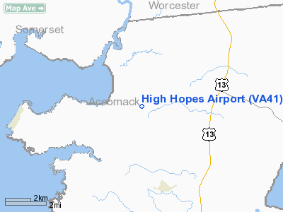
Location & QuickFacts
| FAA Information Effective: | 2008-09-25 |
| Airport Identifier: | VA41 |
| Airport Status: | Operational |
| Longitude/Latitude: | 075-36-35.7380W/37-56-04.4470N
-75.609927/37.934569 (Estimated) |
| Elevation: | 9 ft / 2.74 m (Surveyed) |
| Land: | 3 acres |
| From nearest city: | 2 nautical miles SW of Withams, VA |
| Location: | Accomack County, VA |
| Magnetic Variation: | 10W (1985) |
Owner & Manager
| Ownership: | Privately owned |
| Owner: | Mike Smolinski |
| Address: | 7470 Jenkins Bridge Road
Withams, VA 23488 |
| Phone number: | 804-824-6173 |
| Manager: | Mike Smolinski |
| Address: | 7470 Jenkins Bridge Road
Withams, VA 23488 |
| Phone number: | 804-824-6173 |
Airport Operations and Facilities
| Airport Use: | Private |
| Wind indicator: | Yes |
| Segmented Circle: | No |
| Control Tower: | No |
| Sectional chart: | Washington |
| Region: | AEA - Eastern |
| Boundary ARTCC: | ZDC - Washington |
| Tie-in FSS: | DCA - Leesburg |
| FSS Toll Free: | 1-800-WX-BRIEF |
Runway Information
Runway 11/29
| Dimension: | 1640 x 55 ft / 499.9 x 16.8 m |
| Surface: | TURF, |
| |
Runway 11 |
Runway 29 |
| Traffic Pattern: | Right | Left |
| Displaced threshold: | 0.00 ft | 560.00 ft |
| Obstruction: | | 30 ft pline, 30.0 ft from runway |
|
Radio Navigation Aids
| ID |
Type |
Name |
Ch |
Freq |
Var |
Dist |
| BDB | NDB | Accomack | | 336.00 | 11W | 23.7 nm |
| OX | NDB | Landy | | 407.00 | 12W | 32.3 nm |
| CGE | NDB | Cambridge | | 355.00 | 10W | 41.4 nm |
| NHK | NDB | Patuxent | | 400.00 | 10W | 43.1 nm |
| SWL | VORTAC | Snow Hill | 071X | 112.40 | 08W | 10.1 nm |
| SBY | VORTAC | Salisbury | 049X | 111.20 | 12W | 25.1 nm |
| CCV | VORTAC | Cape Charles | 059X | 112.20 | 10W | 39.8 nm |
| PXT | VORTAC | Patuxent | 123X | 117.60 | 10W | 43.0 nm |
Remarks
- VFR USE ONLY, RY 29 DSPLCD TO ENSURE 20:1 CLNC OVER PLINE; PILOTS BRIEFED REGARDING CLOSE PROXIMITY OF MIL TRAINING ROUTE.
Images and information placed above are from
http://www.airport-data.com/airport/VA41/
We thank them for the data!
| General Info
|
| Country |
United States
|
| State |
VIRGINIA
|
| FAA ID |
VA41
|
| Latitude |
37-56-04.447N
|
| Longitude |
075-36-35.738W
|
| Elevation |
9 feet
|
| Near City |
WITHAMS
|
We don't guarantee the information is fresh and accurate. The data may
be wrong or outdated.
For more up-to-date information please refer to other sources.
|
|


