 |
|
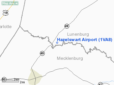
Location & QuickFacts
| FAA Information Effective: | 2008-09-25 |
| Airport Identifier: | 1VA8 |
| Airport Status: | Operational |
| Longitude/Latitude: | 078-24-40.0000W/36-51-43.0000N
-78.411111/36.861944 (Estimated) |
| Elevation: | 485 ft / 147.83 m (Estimated) |
| Land: | 25 acres |
| From nearest city: | 6 nautical miles NE of Chase City, VA |
| Location: | Lunenburg County, VA |
| Magnetic Variation: | 08W (1995) |
Owner & Manager
| Ownership: | Privately owned |
| Owner: | Ralph W Hazelswart |
| Address: | Rt 2 Box 1240
Chase City, VA 23924 |
| Phone number: | 804-372-5901 |
| Manager: | Ralph W Hazelswart |
| Address: | Rt 2 Box 1240
Chase City, VA 23924 |
| Phone number: | 804-372-5901 |
Airport Operations and Facilities
| Airport Use: | Private |
| Wind indicator: | Yes |
| Segmented Circle: | No |
| Control Tower: | No |
| Sectional chart: | Washington |
| Region: | AEA - Eastern |
| Boundary ARTCC: | ZDC - Washington |
| Tie-in FSS: | DCA - Leesburg |
| FSS on Airport: | No |
| FSS Toll Free: | 1-800-WX-BRIEF |
Runway Information
Runway 13/31
| Dimension: | 3000 x 60 ft / 914.4 x 18.3 m |
| Surface: | TURF-GRVL, |
| |
Runway 13 |
Runway 31 |
| Traffic Pattern: | Left | Left |
| Displaced threshold: | 600.00 ft
13/31 DSPLCD THLDS MARKED WITH 3 CONES ON EACH SIDE OF RY. | 1150.00 ft |
| Obstruction: | 75 ft trees, 900.0 ft from runway | 60 ft trees, 1150.0 ft from runway |
|
Radio Navigation Aids
| ID |
Type |
Name |
Ch |
Freq |
Var |
Dist |
| MBV | NDB | Mecklenburg/dcmsnd | | 356.00 | 08W | 19.9 nm |
| AEA | NDB | Jones | | 373.00 | 09W | 22.8 nm |
| BKT | NDB | Blackstone | | 326.00 | 09W | 23.8 nm |
| FVX | NDB | Farmville | | 367.00 | 07W | 29.5 nm |
| HXO | NDB | Huntsboro | | 271.00 | 07W | 35.2 nm |
| RZZ | NDB | Rapids | | 407.00 | 08W | 42.3 nm |
| PTB | NDB | Petersburg | | 284.00 | 08W | 43.3 nm |
| LY | NDB | Bojar | | 385.00 | 08W | 46.6 nm |
| HUR | NDB | Person | | 220.00 | 08W | 49.3 nm |
| ELQ | NDB | Emporia | | 261.00 | 10W | 49.7 nm |
| DAN | VOR | Danville | | 113.10 | 06W | 47.9 nm |
| LVL | VORTAC | Lawrenceville | 076X | 112.90 | 08W | 24.6 nm |
| SBV | VORTAC | South Boston | 041X | 110.40 | 05W | 31.2 nm |
| LYH | VORTAC | Lynchburg | 029X | 109.20 | 05W | 46.1 nm |
| FAK | VORTAC | Flat Rock | 080X | 113.30 | 06W | 48.8 nm |
Remarks
- SEE AIRSPACE LETTER DATED 1 AUG 1994.
Images and information placed above are from
http://www.airport-data.com/airport/1VA8/
We thank them for the data!
| General Info
|
| Country |
United States
|
| State |
VIRGINIA
|
| FAA ID |
1VA8
|
| Latitude |
36-51-43.000N
|
| Longitude |
078-24-40.000W
|
| Elevation |
485 feet
|
| Near City |
CHASE CITY
|
We don't guarantee the information is fresh and accurate. The data may
be wrong or outdated.
For more up-to-date information please refer to other sources.
|
|


