 |
|
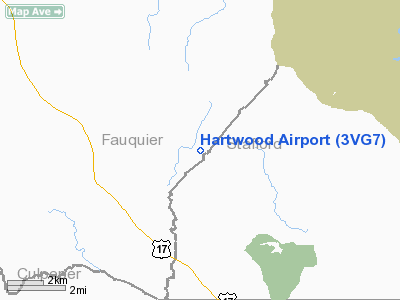
Location & QuickFacts
| FAA Information Effective: | 2008-09-25 |
| Airport Identifier: | 3VG7 |
| Airport Status: | Operational |
| Longitude/Latitude: | 077-36-45.9550W/38-29-04.4500N
-77.612765/38.484569 (Estimated) |
| Elevation: | 390 ft / 118.87 m (Estimated) |
| Land: | 100 acres |
| From nearest city: | 3 nautical miles S of Somerville, VA |
| Location: | Fauquier County, VA |
| Magnetic Variation: | 09W (1985) |
Owner & Manager
| Ownership: | Privately owned |
| Owner: | Francis Fortin |
| Address: | 10623 Vale Rd
Oakton, VA 22124 |
| Phone number: | 703-472-0087 |
| Manager: | Francis Fortin |
| Address: | 10623 Vale Rd
Oakton, VA 22124 |
| Phone number: | 703-472-0087 |
Airport Operations and Facilities
| Airport Use: | Private |
| Wind indicator: | Yes |
| Segmented Circle: | No |
| Control Tower: | No |
| Lighting Schedule: | PHONE REQ
FOR LIRL RWY 17/35 PPR CALL 703-752-4784. |
| Landing fee charge: | No |
| Sectional chart: | Washington |
| Region: | AEA - Eastern |
| Boundary ARTCC: | ZDC - Washington |
| Tie-in FSS: | DCA - Leesburg |
| FSS on Airport: | No |
| FSS Toll Free: | 1-800-WX-BRIEF |
| NOTAMs Facility: | DCA (NOTAM-d service avaliable) |
Airport Services
| Bottled Oxygen: | NONE |
| Bulk Oxygen: | NONE |
Runway Information
Runway 09/27
| Dimension: | 2000 x 100 ft / 609.6 x 30.5 m |
| Surface: | TURF, Fair Condition |
| |
Runway 09 |
Runway 27 |
| Traffic Pattern: | Left | Left |
| Obstruction: | 70 ft trees, 1064.0 ft from runway, 146 ft right of centerline, 12:1 slope to clear | 36 ft pole, 48.0 ft from runway, 74 ft left of centerline, 1:1 slope to clear |
|
Runway 17/35
| Dimension: | 2470 x 35 ft / 752.9 x 10.7 m |
| Surface: | GRVL-TURF, Fair Condition |
| Edge Lights: | Non-standard lighting system
NSTD LIRL - PLASTIC LENSES - E OF RY ONLY; RY 35 LGTD THR RELCTD 535 FT; 1935 FT OF RY 35 USBL FOR NIGHT OPNS. LIRL OTS INDEFLY. |
| |
Runway 17 |
Runway 35 |
| Traffic Pattern: | Left | Left |
| Obstruction: | 95 ft trees, 1018.0 ft from runway, 111 ft right of centerline, 8:1 slope to clear
35-40 FT TREES CROSS EXTDD CNTRLN. | 55 ft trees, 1026.0 ft from runway, 208 ft right of centerline, 15:1 slope to clear |
|
Radio Navigation Aids
| ID |
Type |
Name |
Ch |
Freq |
Var |
Dist |
| CJR | NDB | Culpeper | | 252.00 | 09W | 11.9 nm |
| MSQ | NDB | Nailr | | 351.00 | 10W | 13.9 nm |
| EZF | NDB | Shannon | | 237.00 | 10W | 15.2 nm |
| APH | NDB | A P Hill | | 396.00 | 10W | 27.4 nm |
| GDX | NDB | Goodwin Lake | | 227.00 | 08W | 30.0 nm |
| IQK | NDB | Louisa | | 382.00 | 09W | 30.2 nm |
| DC | NDB | Oxonn | | 332.00 | 11W | 32.3 nm |
| VKX | NDB | Potomac | | 241.00 | 10W | 34.7 nm |
| GTN | NDB | Georgetown | | 323.00 | 09W | 35.2 nm |
| TZ | NDB | Cogan | | 364.00 | 10W | 42.0 nm |
| LUA | NDB | Caverns | | 245.00 | 09W | 42.4 nm |
| LJK | NDB | Ashey | | 280.00 | 09W | 43.2 nm |
| GAI | NDB | Gaithersburg | | 385.00 | 09W | 46.2 nm |
| DCA | VOR/DME | Washington | 047X | 111.00 | 09W | 35.2 nm |
| BRV | VORTAC | Brooke | 092X | 114.50 | 09W | 15.1 nm |
| CSN | VORTAC | Casanova | 110X | 116.30 | 06W | 15.2 nm |
| AML | VORTAC | Armel | 082X | 113.50 | 08W | 27.9 nm |
| LDN | VORTAC | Linden | 090X | 114.30 | 06W | 35.6 nm |
| GVE | VORTAC | Gordonsville | 103X | 115.60 | 06W | 38.1 nm |
| ADW | VORTAC | Andrews | 078X | 113.10 | 10W | 40.1 nm |
| OTT | VORTAC | Nottingham | 084X | 113.70 | 10W | 42.9 nm |
| DCA | VOT | Washington National | | 109.40 | | 34.8 nm |
| ADW | VOT | Andrews Afb | | 109.60 | | 38.9 nm |
Remarks
- EXPERIMENTAL ACFT & GLIDER ACTIVITY ON & INVOF ARPT.
- VFR USE ONLY.
Images and information placed above are from
http://www.airport-data.com/airport/3VG7/
We thank them for the data!
|
|


