 |
|
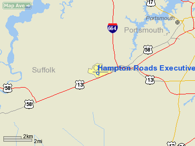
Hampton Roads Executive Airport |
Coordinates: 36°46′49″N 076°26′56″W / 36.78028°N 76.44889°W / 36.78028; -76.44889
| Hampton Roads Executive Airport |
| IATA: none – ICAO: KPVG – FAA LID: PVG |
| Summary |
| Airport type |
Public |
| Owner |
Virginia Aviation Associates, L.L.C |
| Serves |
Norfolk, Virginia |
| Elevation AMSL |
23 ft / 7 m |
| Runways |
| Direction |
Length |
Surface |
| ft |
m |
| 10/28 |
4,056 |
1,236 |
Asphalt |
| 2/20 |
3,524 |
1,074 |
Asphalt |
| Statistics (2004) |
| Aircraft operations |
86,805 |
| Based aircraft |
203 |
| Source: Federal Aviation Administration |
Hampton Roads Executive Airport (ICAO: KPVG, FAA LID: PVG) is a public-use airport located seven miles (11 km) southwest of the central business district of Norfolk and northwest of Chesapeake, both independent cities in the U.S. state of Virginia. It is privately owned by Virginia Aviation Associates, L.L.C.
Although most U.S. airports use the same three-letter location identifier for the FAA and IATA, Hampton Roads Executive Airport is assigned PVG by the FAA but has no designation from the IATA (which assigned PVG to Pudong International Airport in Shanghai, China).
Facilities and aircraft
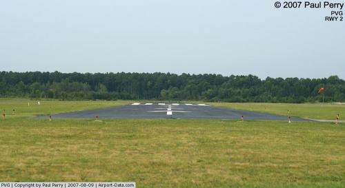
Hampton Roads Executive Airport covers an area of 511 acres (207 ha) which contains two asphalt paved runways: 10/28 measuring 4,056 x 70 ft (1,236 x 21 m) and 2/20 measuring 3,524 x 70 ft (1,074 x 21 m).
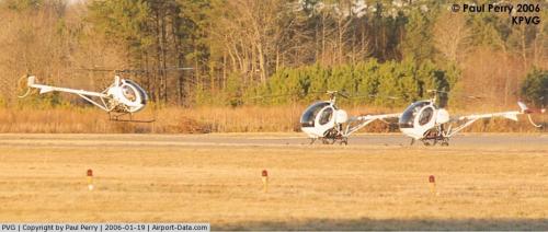
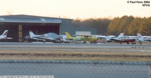
For the 12-month period ending December 31, 2004, the airport had 86,805 aircraft operations, an average of 237 per day: 97% general aviation, 2% air taxi and <1% military. There are 203 aircraft based at this airport: 73% single engine, 14% multi-engine, 8% helicopters and 4% ultralights.
Aerodyne Corporation an FAA certified repair station
Curtis Eads Flight School
The above content comes from Wikipedia and is published under free licenses – click here to read more.
 |
(Click on the photo to enlarge) |
 |
(Click on the photo to enlarge) |
 |
(Click on the photo to enlarge) |
 |
(Click on the photo to enlarge) |
Location & QuickFacts
| FAA Information Effective: | 2008-09-25 |
| Airport Identifier: | PVG |
| Airport Status: | Operational |
| Longitude/Latitude: | 076-26-55.8050W/36-46-48.5360N
-76.448835/36.780149 (Estimated) |
| Elevation: | 23 ft / 7.01 m (Estimated) |
| Land: | 511 acres |
| From nearest city: | 7 nautical miles SW of Norfolk, VA |
| Location: | Chesapeake County, VA |
| Magnetic Variation: | 10W (2000) |
Owner & Manager
| Ownership: | Privately owned |
| Owner: | Virginia Aviation Associates, L.l.c |
| Address: | 5172 W. Military Hwy, Suite A
Chesapeake, VA 23321 |
| Phone number: | 757-465-0260 |
| Manager: | Andy Gibbs
PEGGY F. WHITE & DAVID W. HYNES AUTHORIZED PERSONNEL TO MAKE CHANGES 757-488-9044. |
| Address: | 5172 W. Military Hwy
Chesapeake, VA 23321 |
| Phone number: | 757-465-0260 |
Airport Operations and Facilities
| Airport Use: | Open to public |
| Wind indicator: | Yes |
| Segmented Circle: | No |
| Control Tower: | No |
| Lighting Schedule: | DUSK-DAWN
ACTVT MIRL RYS 02/20 & 10/28 - CTAF. |
| Beacon Color: | Clear-Green (lighted land airport) |
| Landing fee charge: | No |
| Sectional chart: | Washington |
| Region: | AEA - Eastern |
| Boundary ARTCC: | ZDC - Washington |
| Tie-in FSS: | DCA - Leesburg |
| FSS on Airport: | No |
| FSS Toll Free: | 1-800-WX-BRIEF |
| NOTAMs Facility: | DCA (NOTAM-d service avaliable) |
| Federal Agreements: | NGY |
Airport Communications
| CTAF: | 123.000 |
| Unicom: | 123.000 |
Airport Services
| Fuel available: | 100LLA |
| Airframe Repair: | MAJOR |
| Power Plant Repair: | MAJOR |
| Bottled Oxygen: | NONE |
| Bulk Oxygen: | NONE |
Runway Information
Runway 02/20
| Dimension: | 3524 x 70 ft / 1074.1 x 21.3 m |
| Surface: | ASPH, Fair Condition |
| Weight Limit: | Single wheel: 12500 lbs. |
| Edge Lights: | Medium |
| |
Runway 02 |
Runway 20 |
| Longitude: | 076-26-58.3820W | 076-26-51.8350W |
| Latitude: | 36-46-34.8090N | 36-47-09.2590N |
| Elevation: | 21.00 ft | 20.00 ft |
| Alignment: | 9 | 127 |
| Traffic Pattern: | Left | Right |
| Markings: | Non-precision instrument, Good Condition | Non-precision instrument, Good Condition |
| Displaced threshold: | 898.00 ft | 928.00 ft |
| Obstruction: | 10 ft road, 200.0 ft from runway, 250 ft right of centerline
APCH RATIO 70:1 TO DSPLCD THLD; APCH RATIO 27:1 TO DSPLCD THLD FM 73 FT TREE 1318 FT FM RY END, 70 FT LEFT.
+10 FT ROAD 180 FT FM RY END 250 FT R. | 98 ft trees, 1592.0 ft from runway, 14:1 slope to clear
APCH RATIO 23:1 TO DSPLCD THLD
+4 TO +10 FT TREES 20 F FM THLD 75 FT R. |
|
Runway 10/28
| Dimension: | 4056 x 70 ft / 1236.3 x 21.3 m |
| Surface: | ASPH, Fair Condition |
| Weight Limit: | Single wheel: 12500 lbs. |
| Edge Lights: | Medium |
| |
Runway 10 |
Runway 28 |
| Longitude: | 076-27-21.3020W | 076-26-31.4840W |
| Latitude: | 36-46-46.3350N | 36-46-44.6520N |
| Elevation: | 20.00 ft | 16.00 ft |
| Alignment: | 92 | 127 |
| Traffic Pattern: | Right | Left |
| Markings: | Basic, Good Condition | Basic, Good Condition |
| Displaced threshold: | 0.00 ft | 200.00 ft |
| Obstruction: | 72 ft trees, 3024.0 ft from runway, 58 ft right of centerline, 39:1 slope to clear
APRXLY 4 FT DEEP DRAINAGE BASIN WITHIN RY SAFETY AREA. LCTD APRXLY 75 FT LEFT OF CNTRLN, 75 FT PAST RY END TO 325 FT DOWN RY 400 FT LONG. | 88 ft trees, 1457.0 ft from runway, 346 ft left of centerline, 14:1 slope to clear
RY 28 APCH RATIO 16:1 TO DSPLCD THLD. |
|
Radio Navigation Aids
| ID |
Type |
Name |
Ch |
Freq |
Var |
Dist |
| PVG | NDB | Portsmouth | | 241.00 | 10W | 0.2 nm |
| EY | NDB | Chesi | | 233.00 | 09W | 11.3 nm |
| RK | NDB | Waley | | 249.00 | 10W | 14.5 nm |
| PJS | NDB | Henry | | 375.00 | 09W | 21.3 nm |
| FAF | NDB | Felker | | 226.00 | 08W | 23.0 nm |
| AKQ | NDB | Wakefield | | 274.00 | 09W | 29.2 nm |
| LLW | NDB | Woodville | | 254.00 | 10W | 31.9 nm |
| ASJ | NDB | Ahoskie | | 415.00 | 10W | 45.5 nm |
| EDE | NDB | Edenton | | 265.00 | 10W | 45.7 nm |
| ELQ | NDB | Emporia | | 261.00 | 10W | 48.1 nm |
| NGU | TACAN | Chambers | 048X | | 10W | 12.7 nm |
| LFI | TACAN | Langley | 070X | | 10W | 18.9 nm |
| NTU | TACAN | Oceana | 113X | | 10W | 20.0 nm |
| ECG | VOR/DME | Elizabeth City | 072X | 112.50 | 07W | 34.1 nm |
| ORF | VORTAC | Norfolk | 116X | 116.90 | 07W | 13.7 nm |
| FKN | VORTAC | Franklin | 043X | 110.60 | 09W | 27.4 nm |
| CVI | VORTAC | Cofield | 093X | 114.60 | 09W | 31.9 nm |
| CCV | VORTAC | Cape Charles | 059X | 112.20 | 10W | 40.4 nm |
| HCM | VORTAC | Harcum | 025X | 108.80 | 07W | 42.1 nm |
| HPW | VORTAC | Hopewell | 057X | 112.00 | 06W | 46.0 nm |
Remarks
- 1049 FT MSL TWRS 1.5 NM NW OF FLD.
- DEER ON & INVOF ARPT.
- EXTENSIVE HELICOPTER TRAINING.
- RY 10/28 PREFERRED USE RY. BE ALERT FOR MULTIPLE TALL TWRS NW OF ARPT.
- IN OPERN PRIOR TO 1959.
Images and information placed above are from
http://www.airport-data.com/airport/PVG/
We thank them for the data!
| General Info
|
| Country |
United States
|
| State |
VIRGINIA
|
| FAA ID |
PVG
|
| Latitude |
36-46-48.536N
|
| Longitude |
076-26-55.805W
|
| Elevation |
23 feet
|
| Near City |
NORFOLK
|
We don't guarantee the information is fresh and accurate. The data may
be wrong or outdated.
For more up-to-date information please refer to other sources.
|
|


