 |
|
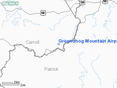
Groundhog Mountain Airport |
Location & QuickFacts
| FAA Information Effective: | 2008-09-25 |
| Airport Identifier: | 00VI |
| Airport Status: | Operational |
| Longitude/Latitude: | 080-29-58.2000W/36-39-48.0000N
-80.499500/36.663333 (Estimated) |
| Elevation: | 2680 ft / 816.86 m () |
| Land: | 0 acres |
| From nearest city: | 12 nautical miles E of Hillsville, VA |
| Location: | Carroll County, VA |
| Magnetic Variation: | 07W (2000) |
Owner & Manager
| Ownership: | Privately owned |
| Owner: | James C. Harrison Jr. |
| Address: | 186367 Blue Ridge Pky
Hillsville, VA 24343 |
| Phone number: | 540-398-3284 |
| Manager: | James C. Harrison Jr. |
| Address: | 186367 Blue Ridge Pky
Hillsville, VA 24343 |
| Phone number: | 540-398-3284 |
Airport Operations and Facilities
| Airport Use: | Private |
| Wind indicator: | Yes |
| Segmented Circle: | No |
| Control Tower: | No |
| Region: | AEA - Eastern |
| Boundary ARTCC: | ZTL - Atlanta |
| Tie-in FSS: | DCA - Leesburg |
| FSS Toll Free: | 1-800-WX-BRIEF |
Runway Information
Runway 09/27
| Dimension: | 1500 x 50 ft / 457.2 x 15.2 m |
| Surface: | TURF, |
| |
Runway 09 |
Runway 27 |
| Traffic Pattern: | Left | Left |
| Obstruction: | 50 ft trees, 150.0 ft from runway | 50 ft trees, 40.0 ft from runway |
|
Radio Navigation Aids
| ID |
Type |
Name |
Ch |
Freq |
Var |
Dist |
| OQA | FAN MARKER | Rockingham County | | | | 35.3 nm |
| HLX | NDB | Hillsville | | 269.00 | 06W | 16.6 nm |
| AZW | NDB | Mount Airy | | 223.00 | 07W | 17.1 nm |
| ZEF | NDB | Zephyr | | 326.00 | 05W | 23.7 nm |
| UV | NDB | Bales | | 396.00 | 07W | 28.4 nm |
| TEC | NDB | Tech | | 368.00 | 06W | 33.1 nm |
| MK | NDB | Suzze | | 335.00 | 06W | 39.0 nm |
| SIF | NDB | Slammer | | 423.00 | 07W | 39.4 nm |
| CNQ | NDB | Callahan | | 379.00 | 05W | 39.5 nm |
| JU | NDB | Ashee | | 410.00 | 07W | 42.0 nm |
| UKF | NDB | Wilki | | 209.00 | 06W | 44.0 nm |
| VIT | NDB | Vinton | | 277.00 | 06W | 44.0 nm |
| DVZ | NDB | Davie | | 354.00 | 06W | 45.1 nm |
| ODR | VOR | Woodrum | | 114.90 | 06W | 46.9 nm |
| PSK | VORTAC | Pulaski | 115X | 116.80 | 06W | 27.5 nm |
| GSO | VORTAC | Greensboro | 109X | 116.20 | 03W | 44.9 nm |
| ROA | VORTAC | Roanoke | 031X | 109.40 | 04W | 45.8 nm |
Remarks
- PRVDD DALGT VFR; CLEAR 20:1 APCH/DEP PATH; OPERATE IN A MANNER TO MINIMIZE NOISE.
Images and information placed above are from
http://www.airport-data.com/airport/00VI/
We thank them for the data!
| General Info
|
| Country |
United States
|
| State |
VIRGINIA
|
| FAA ID |
00VI
|
| Latitude |
36-39-48.000N
|
| Longitude |
080-29-58.200W
|
| Elevation |
2680 feet
|
| Near City |
HILLSVILLE
|
We don't guarantee the information is fresh and accurate. The data may
be wrong or outdated.
For more up-to-date information please refer to other sources.
|
|


