 |
|
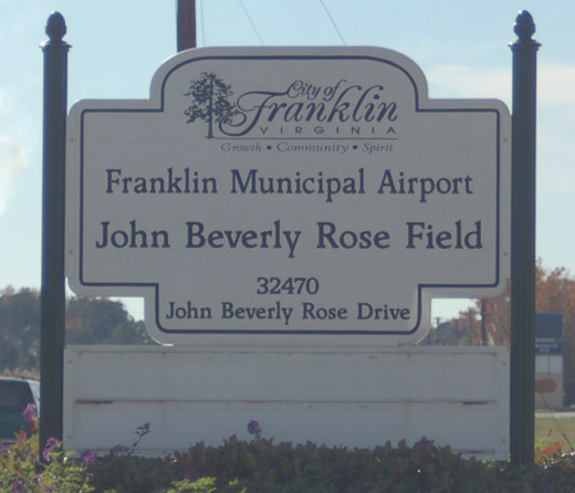
Franklin Muni-john Beverly Rose Airport |
Franklin Municipal Airport
John Beverly Rose Field |
 |
 |
| IATA: FKN – ICAO: KFKN – FAA LID: FKN |
| Summary |
| Airport type |
Public |
| Owner |
City of Franklin |
| Serves |
Franklin, Virginia |
| Elevation AMSL |
41 ft / 12 m |
| Coordinates |
36°41′53″N 076°54′14″W / 36.69806°N 76.90389°W / 36.69806; -76.90389 |
| Website |
FranklinVA.com/... |
| Runways |
| Direction |
Length |
Surface |
| ft |
m |
| 9/27 |
4,977 |
1,517 |
Asphalt |
| Statistics (2007) |
| Aircraft operations |
5,012 |
| Based aircraft |
25 |
| Source: Airport website and FAA |
Franklin Municipal-John Beverly Rose Airport, also known as Franklin Municipal Airport or John Beverly Rose Field (IATA: FKN, ICAO: KFKN, FAA LID: FKN) is a public airport in Isle of Wight County, Virginia, United States. The airport is owned by the City of Franklin and is located at 32470 John Beverly Rose Drive, two nautical miles (4 km) northeast of the city's central business district.
Facilities and aircraft
Franklin Municipal Airport covers an area of 313 acres (127 ha) at an elevation of 41 feet (12 m) above mean sea level. It has one runway designated 9/27 with a 4,977 x 100 ft (1,517 x 30 m) asphalt surface. Two former runways, 14/32 and 4/22, are in no longer used and marked with yellow X's.
For the 12-month period ending March 31, 2007, the airport had 5,012 aircraft operations, an average of 13 per day: 70% general aviation, 30% military and <1% air taxi. At that time there were 25 aircraft based at this airport: 84% single-engine, 12% multi-engine and 4% ultralight.
The above content comes from Wikipedia and is published under free licenses – click here to read more.

 |
(Click on the photo to enlarge) |
 |
(Click on the photo to enlarge) |
 |
(Click on the photo to enlarge) |
Location & QuickFacts
| FAA Information Effective: | 2008-09-25 |
| Airport Identifier: | FKN |
| Airport Status: | Operational |
| Longitude/Latitude: | 076-54-13.6870W/36-41-53.1140N
-76.903802/36.698087 (Estimated) |
| Elevation: | 41 ft / 12.50 m (Surveyed) |
| Land: | 313 acres |
| From nearest city: | 2 nautical miles NE of Franklin, VA |
| Location: | Isle Of Wight County, VA |
| Magnetic Variation: | 09W (1985) |
Owner & Manager
| Ownership: | Publicly owned |
| Owner: | City Of Franklin |
| Address: | P O Box 179
Franklin, VA 23851 |
| Phone number: | 757-562-8501 |
| Manager: | Jimmy Gray |
| Address: | 32470 John Beverly Rose Dr
Franklin, VA 23851 |
| Phone number: | 757-562-8764
CTC 757-562-8575 FOR AFTER HOUR EMERGENCIES. |
Airport Operations and Facilities
| Airport Use: | Open to public |
| Wind indicator: | Yes |
| Segmented Circle: | No |
| Control Tower: | No |
| Lighting Schedule: | DUSK-DAWN
ACTVT MIRL 09/27 - CTAF. |
| Beacon Color: | Clear-Green (lighted land airport) |
| Landing fee charge: | No |
| Sectional chart: | Washington |
| Region: | AEA - Eastern |
| Boundary ARTCC: | ZDC - Washington |
| Tie-in FSS: | DCA - Leesburg |
| FSS on Airport: | No |
| FSS Toll Free: | 1-800-WX-BRIEF |
| NOTAMs Facility: | FKN (NOTAM-d service avaliable) |
| Federal Agreements: | NGRY3 |
Airport Communications
| CTAF: | 122.800 |
| Unicom: | 122.800 |
Airport Services
| Fuel available: | 100LLA |
| Airframe Repair: | MAJOR |
| Power Plant Repair: | MAJOR |
| Bottled Oxygen: | NONE |
| Bulk Oxygen: | NONE |
Runway Information
Runway 09/27
| Dimension: | 4977 x 100 ft / 1517.0 x 30.5 m |
| Surface: | ASPH, Fair Condition |
| Edge Lights: | Medium |
| |
Runway 09 |
Runway 27 |
| Longitude: | 076-54-37.8900W | 076-53-37.5260W |
| Latitude: | 36-41-57.2190N | 36-42-04.9320N |
| Elevation: | 35.00 ft | 41.00 ft |
| Alignment: | 81 | 127 |
| Traffic Pattern: | Left | Left |
| Markings: | Non-precision instrument, Fair Condition | Non-precision instrument, Fair Condition |
| Crossing Height: | 46.00 ft | 0.00 ft |
| VASI: | 2-light PAPI on left side | 2-light PAPI on left side |
| Visual Glide Angle: | 3.00° | 0.00° |
| Obstruction: | 23 ft brush, 323.0 ft from runway, 254 ft right of centerline, 5:1 slope to clear | 11 ft brush, 318.0 ft from runway, 251 ft left of centerline, 10:1 slope to clear
4 FT HIGH FENCE 139 FT FM RY END, 242 FT LEFT ON APCH. |
|
Radio Navigation Aids
| ID |
Type |
Name |
Ch |
Freq |
Var |
Dist |
| RK | NDB | Waley | | 249.00 | 10W | 13.6 nm |
| AKQ | NDB | Wakefield | | 274.00 | 09W | 17.8 nm |
| PVG | NDB | Portsmouth | | 241.00 | 10W | 22.6 nm |
| ELQ | NDB | Emporia | | 261.00 | 10W | 25.6 nm |
| EY | NDB | Chesi | | 233.00 | 09W | 25.9 nm |
| ASJ | NDB | Ahoskie | | 415.00 | 10W | 27.3 nm |
| FAF | NDB | Felker | | 226.00 | 08W | 29.8 nm |
| PJS | NDB | Henry | | 375.00 | 09W | 32.7 nm |
| LLW | NDB | Woodville | | 254.00 | 10W | 39.3 nm |
| PTB | NDB | Petersburg | | 284.00 | 08W | 41.4 nm |
| RZZ | NDB | Rapids | | 407.00 | 08W | 41.8 nm |
| EDE | NDB | Edenton | | 265.00 | 10W | 43.6 nm |
| CF | NDB | Pubbs | | 392.00 | 09W | 46.4 nm |
| NGU | TACAN | Chambers | 048X | | 10W | 33.5 nm |
| LFI | TACAN | Langley | 070X | | 10W | 35.0 nm |
| NTU | TACAN | Oceana | 113X | | 10W | 42.4 nm |
| ECG | VOR/DME | Elizabeth City | 072X | 112.50 | 07W | 44.0 nm |
| FKN | VORTAC | Franklin | 043X | 110.60 | 09W | 5.3 nm |
| CVI | VORTAC | Cofield | 093X | 114.60 | 09W | 19.6 nm |
| ORF | VORTAC | Norfolk | 116X | 116.90 | 07W | 35.8 nm |
| HPW | VORTAC | Hopewell | 057X | 112.00 | 06W | 39.3 nm |
| HCM | VORTAC | Harcum | 025X | 108.80 | 07W | 46.1 nm |
| LVL | VORTAC | Lawrenceville | 076X | 112.90 | 08W | 48.7 nm |
Remarks
- DEER ON AND INVOF ARPT
- GCO AVBL ON FREQ 135.075 THRU ORF CLEARANCE DELIVERY. GCO UNRELIABLE INDEFLY.
- PSBL TFC FM THE SOUTHAMPTON MEMORIAL HELIPAD 2 NM W OF ARPT.
- DRAINAGE DITCHES NEXT TO RY & TWYS.
- IN OPERATION PRIOR TO 1959
Images and information placed above are from
http://www.airport-data.com/airport/FKN/
We thank them for the data!
| General Info
|
| Country |
United States
|
| State |
VIRGINIA
|
| FAA ID |
FKN
|
| Latitude |
36-41-53.114N
|
| Longitude |
076-54-13.687W
|
| Elevation |
41 feet
|
| Near City |
FRANKLIN
|
We don't guarantee the information is fresh and accurate. The data may
be wrong or outdated.
For more up-to-date information please refer to other sources.
|
|


