 |
|
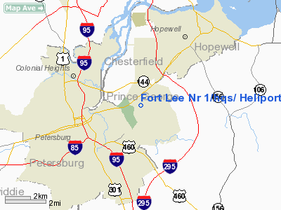
Fort Lee Nr 1/hqs/ Heliport |
Location & QuickFacts
| FAA Information Effective: | 2008-09-25 |
| Airport Identifier: | VA35 |
| Airport Status: | Operational |
| Longitude/Latitude: | 077-20-34.9280W/37-14-30.5390N
-77.343036/37.241816 (Estimated) |
| Elevation: | 100 ft / 30.48 m (Estimated) |
| Land: | 0 acres |
| From nearest city: | 0 nautical miles of Fort Lee, VA |
| Location: | Prince George County, VA |
| Magnetic Variation: | 09W (1985) |
Owner & Manager
| Ownership: | Army owned |
| Owner: | Us Army Atca-aso |
| Address: | Cameron Station
Alexandria, VA 22314 |
| Address: |
|
Airport Operations and Facilities
| Airport Use: | Private |
| Segmented Circle: | No |
| Control Tower: | No |
| Sectional chart: | Washington |
| Region: | AEA - Eastern |
| Boundary ARTCC: | ZDC - Washington |
| Tie-in FSS: | DCA - Leesburg |
| FSS Toll Free: | 1-800-WX-BRIEF |
Runway Information
Helipad H1
| Dimension: | 400 x 400 ft / 121.9 x 121.9 m |
| Surface: | TURF, |
| |
Runway H1 |
Runway |
| Traffic Pattern: | Left | Left |
|
Radio Navigation Aids
| ID |
Type |
Name |
Ch |
Freq |
Var |
Dist |
| CF | NDB | Pubbs | | 392.00 | 09W | 7.6 nm |
| PTB | NDB | Petersburg | | 284.00 | 08W | 13.0 nm |
| AKQ | NDB | Wakefield | | 274.00 | 09W | 22.6 nm |
| LJK | NDB | Ashey | | 280.00 | 09W | 32.6 nm |
| BKT | NDB | Blackstone | | 326.00 | 09W | 34.3 nm |
| FAF | NDB | Felker | | 226.00 | 08W | 35.2 nm |
| ELQ | NDB | Emporia | | 261.00 | 10W | 37.7 nm |
| PJS | NDB | Henry | | 375.00 | 09W | 41.2 nm |
| MBV | NDB | Mecklenburg/dcmsnd | | 356.00 | 08W | 47.6 nm |
| LFI | TACAN | Langley | 070X | | 10W | 48.0 nm |
| HPW | VORTAC | Hopewell | 057X | 112.00 | 06W | 12.1 nm |
| RIC | VORTAC | Richmond | 088X | 114.10 | 09W | 15.7 nm |
| FAK | VORTAC | Flat Rock | 080X | 113.30 | 06W | 28.9 nm |
| HCM | VORTAC | Harcum | 025X | 108.80 | 07W | 32.6 nm |
| FKN | VORTAC | Franklin | 043X | 110.60 | 09W | 35.5 nm |
| LVL | VORTAC | Lawrenceville | 076X | 112.90 | 08W | 37.0 nm |
Remarks
- NO NGT OPNS AUTH.
- PPR & BRIEFING OF ACFT COMDR RQRD PRIOR TO OPERATION. V687-4504.
- HELIPAD CLSD PERMLY.
Images and information placed above are from
http://www.airport-data.com/airport/VA35/
We thank them for the data!
| General Info
|
| Country |
United States
|
| State |
VIRGINIA
|
| FAA ID |
VA35
|
| Latitude |
37-14-30.539N
|
| Longitude |
077-20-34.928W
|
| Elevation |
100 feet
|
| Near City |
FORT LEE
|
We don't guarantee the information is fresh and accurate. The data may
be wrong or outdated.
For more up-to-date information please refer to other sources.
|
|


