 |
|
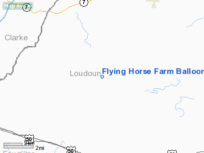
Flying Horse Farm Balloonport Airport |
Location & QuickFacts
| FAA Information Effective: | 2008-09-25 |
| Airport Identifier: | VA60 |
| Airport Status: | Operational |
| Longitude/Latitude: | 077-46-38.9800W/39-03-05.3860N
-77.777494/39.051496 (Estimated) |
| Elevation: | 450 ft / 137.16 m (Estimated) |
| Land: | 21 acres |
| From nearest city: | 2 nautical miles N of Unison, VA |
| Location: | Loudoun County, VA |
| Magnetic Variation: | 09W (1985) |
Owner & Manager
| Ownership: | Privately owned |
| Owner: | Robert O. G. Thomas |
| Address: | 20273 Unison Rd
Round Hill, VA 20141 |
| Phone number: | 703-281-2300 |
| Address: |
|
| Phone number: | 703-554-2002 |
Airport Operations and Facilities
| Airport Use: | Private |
| Wind indicator: | Yes |
| Segmented Circle: | No |
| Control Tower: | No |
| Sectional chart: | Washington |
| Region: | AEA - Eastern |
| Boundary ARTCC: | ZDC - Washington |
| Tie-in FSS: | DCA - Leesburg |
| FSS Toll Free: | 1-800-WX-BRIEF |
Runway Information
Balloonport B1
| Dimension: | 300 x 300 ft / 91.4 x 91.4 m |
| Surface: | TURF, |
| |
Runway B1 |
Runway |
| Traffic Pattern: | Left | Left |
|
Radio Navigation Aids
| ID |
Type |
Name |
Ch |
Freq |
Var |
Dist |
| GDX | NDB | Goodwin Lake | | 227.00 | 08W | 6.4 nm |
| TZ | NDB | Cogan | | 364.00 | 10W | 13.7 nm |
| GAI | NDB | Gaithersburg | | 385.00 | 09W | 29.4 nm |
| GTN | NDB | Georgetown | | 323.00 | 09W | 31.4 nm |
| CJR | NDB | Culpeper | | 252.00 | 09W | 31.5 nm |
| MSQ | NDB | Nailr | | 351.00 | 10W | 36.4 nm |
| LUA | NDB | Caverns | | 245.00 | 09W | 38.8 nm |
| DC | NDB | Oxonn | | 332.00 | 11W | 39.1 nm |
| VKX | NDB | Potomac | | 241.00 | 10W | 42.5 nm |
| BUH | NDB | Anne Arundel | | 260.00 | 10W | 47.5 nm |
| FND | NDB | Ellicott | | 371.00 | 11W | 48.7 nm |
| EZF | NDB | Shannon | | 237.00 | 10W | 49.6 nm |
| FDK | VOR | Frederick | | 109.00 | 08W | 28.7 nm |
| HGR | VOR | Hagerstown | | 109.80 | 07W | 39.0 nm |
| DCA | VOR/DME | Washington | 047X | 111.00 | 09W | 36.5 nm |
| AML | VORTAC | Armel | 082X | 113.50 | 08W | 16.1 nm |
| MRB | VORTAC | Martinsburg | 058X | 112.10 | 07W | 20.3 nm |
| LDN | VORTAC | Linden | 090X | 114.30 | 06W | 23.3 nm |
| CSN | VORTAC | Casanova | 110X | 116.30 | 06W | 25.0 nm |
| ADW | VORTAC | Andrews | 078X | 113.10 | 10W | 45.1 nm |
| EMI | VORTAC | Westminster | 126X | 117.90 | 08W | 45.7 nm |
| BRV | VORTAC | Brooke | 092X | 114.50 | 09W | 47.4 nm |
| DCA | VOT | Washington National | | 109.40 | | 36.9 nm |
| ADW | VOT | Andrews Afb | | 109.60 | | 44.9 nm |
Remarks
- VFR USE ONLY; ENTER INTO 'LTR OF AGREEMENT' WITH DULLES ATCT; COORD ALL OPS WITH DULLES ATCT.
Images and information placed above are from
http://www.airport-data.com/airport/VA60/
We thank them for the data!
| General Info
|
| Country |
United States
|
| State |
VIRGINIA
|
| FAA ID |
VA60
|
| Latitude |
39-03-05.386N
|
| Longitude |
077-46-38.980W
|
| Elevation |
450 feet
|
| Near City |
UNISON
|
We don't guarantee the information is fresh and accurate. The data may
be wrong or outdated.
For more up-to-date information please refer to other sources.
|
|


