 |
|
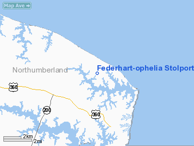
Federhart-ophelia Stolport Airport |
Location & QuickFacts
| FAA Information Effective: | 2008-09-25 |
| Airport Identifier: | VA99 |
| Airport Status: | Operational |
| Longitude/Latitude: | 076-17-25.8000W/37-54-21.4630N
-76.290500/37.905962 (Estimated) |
| Elevation: | 13 ft / 3.96 m (Estimated) |
| Land: | 26 acres |
| From nearest city: | 4 nautical miles N of Reedville, VA |
| Location: | Northumberland County, VA |
| Magnetic Variation: | 10W (1985) |
Owner & Manager
| Ownership: | Privately owned |
| Owner: | John A. Federhart |
| Address: | Box 247
Ophelia, VA 22530-0247
BOX 247, OPHELIA, VA 22530. |
| Phone number: | 804-453-3064
804-453-3064. |
| Manager: | John A. Federhart |
| Address: | Box 247
Ophelia, VA 22530-0247 |
| Phone number: | 805-453-3064 |
Airport Operations and Facilities
| Airport Use: | Private |
| Wind indicator: | Yes |
| Segmented Circle: | No |
| Control Tower: | No |
| Landing fee charge: | No |
| Sectional chart: | Washington |
| Region: | AEA - Eastern |
| Boundary ARTCC: | ZDC - Washington |
| Tie-in FSS: | DCA - Leesburg |
| FSS on Airport: | No |
| FSS Toll Free: | 1-800-WX-BRIEF |
Airport Services
| Airframe Repair: | NONE |
| Power Plant Repair: | NONE |
Runway Information
Runway N/S
| Dimension: | 2200 x 80 ft / 670.6 x 24.4 m |
| Surface: | TURF, Good Condition |
| |
Runway N |
Runway S |
| Traffic Pattern: | Left | Left |
| Obstruction: | 60 ft trees, 150.0 ft from runway | 70 ft trees, 450.0 ft from runway |
|
Radio Navigation Aids
| ID |
Type |
Name |
Ch |
Freq |
Var |
Dist |
| NHK | NDB | Patuxent | | 400.00 | 10W | 23.5 nm |
| BDB | NDB | Accomack | | 336.00 | 11W | 30.9 nm |
| CGE | NDB | Cambridge | | 355.00 | 10W | 39.9 nm |
| PJS | NDB | Henry | | 375.00 | 09W | 47.5 nm |
| FAF | NDB | Felker | | 226.00 | 08W | 48.7 nm |
| LFI | TACAN | Langley | 070X | | 10W | 49.4 nm |
| PXT | VORTAC | Patuxent | 123X | 117.60 | 10W | 23.5 nm |
| HCM | VORTAC | Harcum | 025X | 108.80 | 07W | 34.0 nm |
| CCV | VORTAC | Cape Charles | 059X | 112.20 | 10W | 36.3 nm |
| SWL | VORTAC | Snow Hill | 071X | 112.40 | 08W | 40.2 nm |
| SBY | VORTAC | Salisbury | 049X | 111.20 | 12W | 45.3 nm |
Remarks
Images and information placed above are from
http://www.airport-data.com/airport/VA99/
We thank them for the data!
| General Info
|
| Country |
United States
|
| State |
VIRGINIA
|
| FAA ID |
VA99
|
| Latitude |
37-54-21.463N
|
| Longitude |
076-17-25.800W
|
| Elevation |
13 feet
|
| Near City |
REEDVILLE
|
We don't guarantee the information is fresh and accurate. The data may
be wrong or outdated.
For more up-to-date information please refer to other sources.
|
|


