 |
|
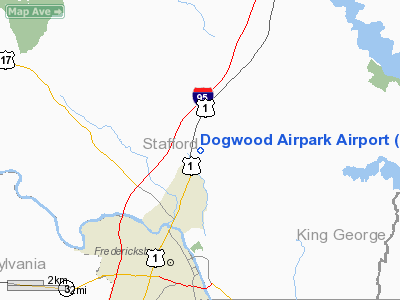
Location & QuickFacts
| FAA Information Effective: | 2008-09-25 |
| Airport Identifier: | VA42 |
| Airport Status: | Operational |
| Longitude/Latitude: | 077-27-07.9420W/38-21-30.4560N
-77.452206/38.358460 (Estimated) |
| Elevation: | 180 ft / 54.86 m (Estimated) |
| Land: | 9 acres |
| From nearest city: | 3 nautical miles N of Fredericksburg, VA |
| Location: | Stafford County, VA |
| Magnetic Variation: | 09W (1985) |
Owner & Manager
| Ownership: | Privately owned |
| Owner: | Dogwood Airpark Assn |
| Address: | 60 Airpark Blvd
Fredericksburg, VA 22405 |
| Phone number: | 540-899-9500 |
| Manager: | Hampton K Miller |
| Address: | 50 Cessna La
Fredericksburg, VA 22405-1418 |
| Phone number: | 703-899-0516 |
Airport Operations and Facilities
| Airport Use: | Private |
| Wind indicator: | Yes |
| Segmented Circle: | No |
| Control Tower: | No |
| Lighting Schedule: | RDO-CTL
ACTVT LIRL RY 09/27 - 122.7. |
| Landing fee charge: | No |
| Sectional chart: | Washington |
| Region: | AEA - Eastern |
| Boundary ARTCC: | ZDC - Washington |
| Tie-in FSS: | DCA - Leesburg |
| FSS on Airport: | No |
| FSS Toll Free: | 1-800-WX-BRIEF |
Runway Information
Runway 09/27
| Dimension: | 4100 x 50 ft / 1249.7 x 15.2 m |
| Surface: | ASPH, Good Condition |
| Edge Lights: | Low |
| |
Runway 09 |
Runway 27 |
| Traffic Pattern: | Right | Left |
| Markings: | Basic, Good Condition | Basic, Good Condition |
| Displaced threshold: | 200.00 ft | 1300.00 ft |
| Obstruction: | 70 ft pline, 200.0 ft from runway | 80 ft pline, 1300.0 ft from runway |
|
Radio Navigation Aids
| ID |
Type |
Name |
Ch |
Freq |
Var |
Dist |
| EZF | NDB | Shannon | | 237.00 | 10W | 5.5 nm |
| APH | NDB | A P Hill | | 396.00 | 10W | 17.3 nm |
| CJR | NDB | Culpeper | | 252.00 | 09W | 21.7 nm |
| MSQ | NDB | Nailr | | 351.00 | 10W | 22.1 nm |
| IQK | NDB | Louisa | | 382.00 | 09W | 28.0 nm |
| DC | NDB | Oxonn | | 332.00 | 11W | 31.6 nm |
| VKX | NDB | Potomac | | 241.00 | 10W | 33.1 nm |
| LJK | NDB | Ashey | | 280.00 | 09W | 35.2 nm |
| GTN | NDB | Georgetown | | 323.00 | 09W | 37.6 nm |
| GDX | NDB | Goodwin Lake | | 227.00 | 08W | 40.0 nm |
| NHK | NDB | Patuxent | | 400.00 | 10W | 49.7 nm |
| DCA | VOR/DME | Washington | 047X | 111.00 | 09W | 35.9 nm |
| BRV | VORTAC | Brooke | 092X | 114.50 | 09W | 4.9 nm |
| CSN | VORTAC | Casanova | 110X | 116.30 | 06W | 25.8 nm |
| AML | VORTAC | Armel | 082X | 113.50 | 08W | 34.6 nm |
| ADW | VORTAC | Andrews | 078X | 113.10 | 10W | 38.5 nm |
| GVE | VORTAC | Gordonsville | 103X | 115.60 | 06W | 39.1 nm |
| OTT | VORTAC | Nottingham | 084X | 113.70 | 10W | 39.3 nm |
| LDN | VORTAC | Linden | 090X | 114.30 | 06W | 46.3 nm |
| PXT | VORTAC | Patuxent | 123X | 117.60 | 10W | 49.8 nm |
| DCA | VOT | Washington National | | 109.40 | | 35.2 nm |
| ADW | VOT | Andrews Afb | | 109.60 | | 37.3 nm |
Remarks
- RY 09 NOT AVBL FOR NIGHT LDGS.
- PROVIDED RWY 9 END AT LEAST 300' FM HWY 1.
Images and information placed above are from
http://www.airport-data.com/airport/VA42/
We thank them for the data!
| General Info
|
| Country |
United States
|
| State |
VIRGINIA
|
| FAA ID |
VA42
|
| Latitude |
38-21-30.456N
|
| Longitude |
077-27-07.942W
|
| Elevation |
180 feet
|
| Near City |
FREDERICKSBURG
|
We don't guarantee the information is fresh and accurate. The data may
be wrong or outdated.
For more up-to-date information please refer to other sources.
|
|


