|
|
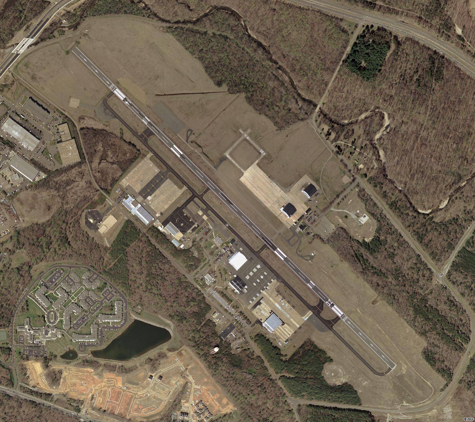
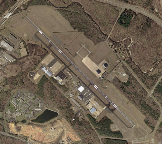
| Davison Army Airfield |
 |
| USGS aerial image as of 10 April 2002 |
| IATA: DAA – ICAO: KDAA – FAA LID: DAA |
| Summary |
| Airport type |
Military |
| Owner |
U.S. Army ATCA-ASO |
| Location |
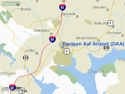
Fort Belvoir, Virginia |
| Elevation AMSL |
73 ft / 22 m |
| Coordinates |
38°42′54″N 077°10′52″W / 38.715°N 77.18111°W / 38.715; -77.18111 |
| Runways |
| Direction |
Length |
Surface |
| ft |
m |
| 14/32 |
5,618 |
1,712 |
Asphalt |
| Source: Federal Aviation Administration |
Davison Army Airfield or Davison AAF (IATA: DAA, ICAO: KDAA, FAA LID: DAA) is a military use airport serving Fort Belvoir, in Fairfax County, Virginia, United States.
The airfield is located 15 miles (24 km) southwest of Washington, D.C. It was named for noted World War II aviation engineer Brig. Gen. Donald Angus Davison.
Facilities
Davison AAF has one runway designated 14/32 with an asphalt surface measuring 5,618 by 74 feet (1,712 x 23 m).
The above content comes from Wikipedia and is published under free licenses – click here to read more.
Location & QuickFacts
| FAA Information Effective: | 2008-09-25 |
| Airport Identifier: | DAA |
| Airport Status: | Operational |
| Longitude/Latitude: | 077-10-51.6000W/38-42-54.0000N
-77.181000/38.715000 (Estimated) |
| Elevation: | 73 ft / 22.25 m (Estimated) |
| Land: | 0 acres |
| From nearest city: | 3 nautical miles NW of Fort Belvoir, VA |
| Location: | Fairfax County, VA |
| Magnetic Variation: | 09W (1985) |
Owner & Manager
| Ownership: | Army owned |
| Owner: | Davison Army Airfield |
| Address: | Us Army Atca-aso, 6970 Britton Dr
Ft Belvior, VA 22060 |
| Address: |
|
| Phone number: | 703-664-1201 |
Airport Operations and Facilities
| Airport Use: | Private |
| Segmented Circle: | No |
| Control Tower: | Yes |
| Lighting Schedule: | DUSK-DAWN |
| Beacon Color: | Split-Clear-Green (lighted military airport) |
| Sectional chart: | Washington |
| Region: | AEA - Eastern |
| Traffic Pattern Alt: | 1100 ft |
| Boundary ARTCC: | ZDC - Washington |
| Tie-in FSS: | DCA - Leesburg |
| FSS on Airport: | No |
| FSS Toll Free: | 1-800-WX-BRIEF |
| NOTAMs Facility: | DCA (NOTAM-d service avaliable) |
Airport Communications
Runway Information
Runway 14/32
| Dimension: | 5618 x 74 ft / 1712.4 x 22.6 m |
| Surface: | ASPH, |
| Pavement Class: | 27 /F/A/W/T |
| Edge Lights: | High |
| |
Runway 14 |
Runway 32 |
| Longitude: | 077-11-17.8390W | 077-10-26.4030W |
| Latitude: | 38-43-13.5070N | 38-42-35.2930N |
| Elevation: | 49.00 ft | 73.00 ft |
| Alignment: | 127 | 127 |
| ILS Type: | | ILS
|
| Traffic Pattern: | Left | Left |
| Crossing Height: | 59.00 ft | 0.00 ft |
| Displaced threshold: | 600.00 ft | 900.00 ft |
| VASI: | 2-light PAPI on left side | |
| Visual Glide Angle: | 3.00° | 0.00° |
| RVR Equipment: | | touchdown |
| Approach lights: |
NATO STD APPROACH LGTS (BP). | MALSF |
| Runway End Identifier: | No | Yes |
|
Radio Navigation Aids
| ID |
Type |
Name |
Ch |
Freq |
Var |
Dist |
| DC | NDB | Oxonn | | 332.00 | 11W | 7.9 nm |
| VKX | NDB | Potomac | | 241.00 | 10W | 10.7 nm |
| GTN | NDB | Georgetown | | 323.00 | 09W | 13.2 nm |
| GAI | NDB | Gaithersburg | | 385.00 | 09W | 27.3 nm |
| BUH | NDB | Anne Arundel | | 260.00 | 10W | 29.7 nm |
| EZF | NDB | Shannon | | 237.00 | 10W | 29.8 nm |
| GDX | NDB | Goodwin Lake | | 227.00 | 08W | 33.7 nm |
| CJR | NDB | Culpeper | | 252.00 | 09W | 33.7 nm |
| MSQ | NDB | Nailr | | 351.00 | 10W | 37.5 nm |
| APH | NDB | A P Hill | | 396.00 | 10W | 38.3 nm |
| FND | NDB | Ellicott | | 371.00 | 11W | 39.2 nm |
| IUB | NDB | Institute | | 404.00 | 08W | 43.1 nm |
| NHK | NDB | Patuxent | | 400.00 | 10W | 44.8 nm |
| TZ | NDB | Cogan | | 364.00 | 10W | 47.1 nm |
| FDK | VOR | Frederick | | 109.00 | 08W | 42.9 nm |
| DCA | VOR/DME | Washington | 047X | 111.00 | 09W | 11.0 nm |
| ADW | VORTAC | Andrews | 078X | 113.10 | 10W | 15.8 nm |
| AML | VORTAC | Armel | 082X | 113.50 | 08W | 18.8 nm |
| OTT | VORTAC | Nottingham | 084X | 113.70 | 10W | 20.5 nm |
| BRV | VORTAC | Brooke | 092X | 114.50 | 09W | 24.2 nm |
| CSN | VORTAC | Casanova | 110X | 116.30 | 06W | 32.4 nm |
| BAL | VORTAC | Baltimore | 098X | 115.10 | 11W | 36.6 nm |
| PXT | VORTAC | Patuxent | 123X | 117.60 | 10W | 44.8 nm |
| EMI | VORTAC | Westminster | 126X | 117.90 | 08W | 47.8 nm |
| LDN | VORTAC | Linden | 090X | 114.30 | 06W | 48.7 nm |
| DCA | VOT | Washington National | | 109.40 | | 10.4 nm |
| ADW | VOT | Andrews Afb | | 109.60 | | 14.8 nm |
Remarks
- FUEL: J8 AVBL 1130-0330Z++ MON-FRI 1300-2200 SAT-SUN AND HOL.
- CLASS D AIRSPACE EFF 1100-0230Z++ MON-FRI EXC HOL, OT CLASS G.
- OIL: 0-123-128-148-156.
- OFFL BUS ONLY. PPR 24 HR NOTICE FOR ALL N0N DAA BASED ACFT,CTC BASE OPS 1200-2100Z++ WKD, DSN 656-7683/7682, C703-806-7682/7683.
- RSTD: 24 HR PPR NVESD RAMP, DSN 656-7675/7676, C703-806-7675/7676.
- CAUTON: EXP SHEAR/CROSSWIND SHIFT TDZ RWY 32 DUR SW-NW WIND. BIRD AND DEER HAZ.
- TFC PAT: F/W SW 1500', R/W/NE 1100'.
- NS ABTMT: TWR WILL ADVS OF RSTD TO ENG RUN-UP, TKOF AND LDG BTN 0300-1300Z++ MON-SAT;2200-1700Z++ SUN AND HOL.
- MISC: WITH CTL TWR/OPR APV, DEP ACFT MAY USE RWY APCH END OVRN FOR TKOF ROLL. WX FCST 1100-0230Z++ MON-FRI,EXC HOL, OT REMOTE BRIEFING SVC AVBL 15TH OWS, SCOTT AFB DSN 576-9755, C618-256-9755, FAX EXTN 4855 0R HTTP://OWS.SCOTT.AF.MIL. SEE VFR-S FOR PENTAGON HELIPORT.
- ARNG: OPR 24/7. 24 HR PPR FOR TRAN ACFT, DSN 656-7092/7690, C703-806-7092/7690 FAX 7298.
Images and information placed above are from
http://www.airport-data.com/airport/DAA/
We thank them for the data!
| General Info
|
| Country |
United States
|
| State |
VIRGINIA
|
| FAA ID |
DAA
|
| Latitude |
38-42-55.414N
|
| Longitude |
077-10-53.932W
|
| Elevation |
74 feet
|
| Near City |
FORT BELVOIR
|
We don't guarantee the information is fresh and accurate. The data may
be wrong or outdated.
For more up-to-date information please refer to other sources.
|
|