 |
|
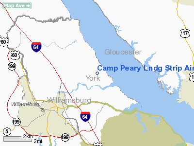
Camp Peary Lndg Strip Airport |
 |
(Click on the photo to enlarge) |
Location & QuickFacts
| FAA Information Effective: | 2008-09-25 |
| Airport Identifier: | W94 |
| Airport Status: | Operational |
| Longitude/Latitude: | 076-38-17.5821W/37-18-46.0594N
-76.638217/37.312794 (Estimated) |
| Elevation: | 41 ft / 12.50 m (Estimated) |
| Land: | 0 acres |
| From nearest city: | 3 nautical miles NE of Williamsburg, VA |
| Location: | York County, VA |
| Magnetic Variation: | 11W (2010) |
Owner & Manager
| Ownership: | Army owned |
| Owner: | Us Army Atca-aso |
| Address: | Cameron Station
Alexandria, VA 22314 |
| Manager: | David J Cromley
COLONEL INFANTRY. |
| Address: | Afeta-camp Peary
Williamsburg, VA 23185 |
| Phone number: | 804-229-2121 |
Airport Operations and Facilities
| Airport Use: | Private
THIS FLD IS DOD RESTRICTED. |
| Wind indicator: | Yes |
| Segmented Circle: | No |
| Control Tower: | No |
| Landing fee charge: | No |
| Sectional chart: | Washington |
| Region: | AEA - Eastern |
| Boundary ARTCC: | ZDC - Washington |
| Tie-in FSS: | DCA - Leesburg |
| FSS on Airport: | No |
| FSS Toll Free: | 1-800-WX-BRIEF |
Airport Services
| Airframe Repair: | NONE |
| Power Plant Repair: | NONE |
Runway Information
Runway 05/23
| Dimension: | 5018 x 151 ft / 1529.5 x 46.0 m
FLD CLSD TO ALL CIV & MIL ACFT WO PRIOR APVL OF BASE COMDR. |
| Surface: | ASPH, |
| |
Runway 05 |
Runway 23 |
| Longitude: | 076-38-37.3042W | 076-37-57.8600W |
| Latitude: | 37-18-26.8949N | 37-19-05.2238N |
| Elevation: | 41.00 ft | 31.00 ft |
| Traffic Pattern: | Left | Left |
|
Radio Navigation Aids
| ID |
Type |
Name |
Ch |
Freq |
Var |
Dist |
| FAF | NDB | Felker | | 226.00 | 08W | 10.5 nm |
| PJS | NDB | Henry | | 375.00 | 09W | 12.9 nm |
| AKQ | NDB | Wakefield | | 274.00 | 09W | 26.4 nm |
| PVG | NDB | Portsmouth | | 241.00 | 10W | 33.3 nm |
| CF | NDB | Pubbs | | 392.00 | 09W | 39.0 nm |
| RK | NDB | Waley | | 249.00 | 10W | 42.9 nm |
| BDB | NDB | Accomack | | 336.00 | 11W | 43.0 nm |
| EY | NDB | Chesi | | 233.00 | 09W | 44.6 nm |
| PTB | NDB | Petersburg | | 284.00 | 08W | 46.1 nm |
| LJK | NDB | Ashey | | 280.00 | 09W | 48.7 nm |
| LFI | TACAN | Langley | 070X | | 10W | 19.1 nm |
| NGU | TACAN | Chambers | 048X | | 10W | 28.3 nm |
| NTU | TACAN | Oceana | 113X | | 10W | 41.2 nm |
| HCM | VORTAC | Harcum | 025X | 108.80 | 07W | 8.9 nm |
| HPW | VORTAC | Hopewell | 057X | 112.00 | 06W | 22.9 nm |
| CCV | VORTAC | Cape Charles | 059X | 112.20 | 10W | 30.7 nm |
| ORF | VORTAC | Norfolk | 116X | 116.90 | 07W | 32.9 nm |
| RIC | VORTAC | Richmond | 088X | 114.10 | 09W | 34.5 nm |
| FKN | VORTAC | Franklin | 043X | 110.60 | 09W | 40.2 nm |
Remarks
Images and information placed above are from
http://www.airport-data.com/airport/W94/
We thank them for the data!
| General Info
|
| Country |
United States
|
| State |
VIRGINIA
|
| FAA ID |
W94
|
| Latitude |
37-18-20.522N
|
| Longitude |
076-38-13.837W
|
| Elevation |
37 feet
|
| Near City |
WILLIAMSBURG
|
We don't guarantee the information is fresh and accurate. The data may
be wrong or outdated.
For more up-to-date information please refer to other sources.
|
|


