 |
|
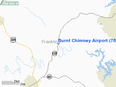
Location & QuickFacts
| FAA Information Effective: | 2008-09-25 |
| Airport Identifier: | 70VA |
| Airport Status: | Operational |
| Longitude/Latitude: | 079-49-38.1180W/37-04-31.5060N
-79.827255/37.075418 (Estimated) |
| Elevation: | 1034 ft / 315.16 m (Estimated) |
| Land: | 0 acres |
| From nearest city: | 2 nautical miles S of Burnt Chimney, VA |
| Location: | Franklin County, VA |
| Magnetic Variation: | 06W (1985) |
Owner & Manager
| Ownership: | Privately owned |
| Owner: | Marlin J. Bowman |
| Address: | P.o. Box 189
Wirtz, VA 24184 |
| Phone number: | 540-263-0083 |
| Manager: | Marlin J. Bowman |
| Address: | P.o. Box 189
Wirtz, VA 24184 |
| Phone number: | 540-263-0083 |
Airport Operations and Facilities
| Airport Use: | Private |
| Wind indicator: | Yes |
| Segmented Circle: | No |
| Control Tower: | No |
| Lighting Schedule: | PHONE REQ
FOR LIRL RY 06/24 CALL 703-721-2045. |
| Sectional chart: | Washington |
| Region: | AEA - Eastern |
| Boundary ARTCC: | ZDC - Washington |
| Tie-in FSS: | DCA - Leesburg |
| FSS Toll Free: | 1-800-WX-BRIEF |
| NOTAMs Facility: | DCA |
Airport Services
Runway Information
Runway 06/24
| Dimension: | 1800 x 50 ft / 548.6 x 15.2 m |
| Surface: | TURF, |
| Edge Lights: | Low |
| |
Runway 06 |
Runway 24 |
| Traffic Pattern: | Left | Left |
| Obstruction: | | 30 ft pline |
|
Radio Navigation Aids
| ID |
Type |
Name |
Ch |
Freq |
Var |
Dist |
| OQA | FAN MARKER | Rockingham County | | | | 39.0 nm |
| VIT | NDB | Vinton | | 277.00 | 06W | 8.2 nm |
| CNQ | NDB | Callahan | | 379.00 | 05W | 19.4 nm |
| TEC | NDB | Tech | | 368.00 | 06W | 28.7 nm |
| UV | NDB | Bales | | 396.00 | 07W | 29.5 nm |
| LY | NDB | Bojar | | 385.00 | 08W | 30.1 nm |
| SIF | NDB | Slammer | | 423.00 | 07W | 41.8 nm |
| ODR | VOR | Woodrum | | 114.90 | 06W | 16.6 nm |
| DAN | VOR | Danville | | 113.10 | 06W | 38.5 nm |
| ROA | VORTAC | Roanoke | 031X | 109.40 | 04W | 19.9 nm |
| LYH | VORTAC | Lynchburg | 029X | 109.20 | 05W | 30.3 nm |
| PSK | VORTAC | Pulaski | 115X | 116.80 | 06W | 42.5 nm |
| SBV | VORTAC | South Boston | 041X | 110.40 | 05W | 45.9 nm |
Images and information placed above are from
http://www.airport-data.com/airport/70VA/
We thank them for the data!
| General Info
|
| Country |
United States
|
| State |
VIRGINIA
|
| FAA ID |
70VA
|
| Latitude |
37-04-31.506N
|
| Longitude |
079-49-38.118W
|
| Elevation |
1034 feet
|
| Near City |
BURNT CHIMNEY
|
We don't guarantee the information is fresh and accurate. The data may
be wrong or outdated.
For more up-to-date information please refer to other sources.
|
|


