 |
|
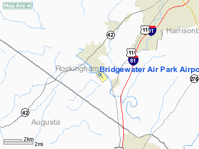
Bridgewater Air Park Airport |
Location & QuickFacts
| FAA Information Effective: | 2008-09-25 |
| Airport Identifier: | VBW |
| Airport Status: | Operational |
| Longitude/Latitude: | 078-57-37.2030W/38-22-00.2550N
-78.960334/38.366737 (Estimated) |
| Elevation: | 1165 ft / 355.09 m (Surveyed) |
| Land: | 90 acres |
| From nearest city: | 1 nautical miles NW of Bridgewater, VA |
| Location: | Rockingham County, VA |
| Magnetic Variation: | 06W (1975) |
Owner & Manager
| Ownership: | Privately owned |
| Owner: | Rockingham Aviation Corp |
| Address: | Po Box 7
Bridgewater, VA 22812 |
| Phone number: | 540-828-3214 |
| Manager: | Karl Stoltzfus Sr |
| Address: | Po Box 7
Bridgewater, VA 22812 |
| Phone number: | 540-828-6070 |
Airport Operations and Facilities
| Airport Use: | Open to public |
| Wind indicator: | Yes |
| Segmented Circle: | No |
| Control Tower: | No |
| Lighting Schedule: | DUSK-DAWN
ACTVT MIRL RY 15/33 - CTAF. |
| Beacon Color: | Clear-Green (lighted land airport) |
| Landing fee charge: | No |
| Sectional chart: | Washington |
| Region: | AEA - Eastern |
| Boundary ARTCC: | ZDC - Washington |
| Tie-in FSS: | DCA - Leesburg |
| FSS on Airport: | No |
| FSS Toll Free: | 1-800-WX-BRIEF |
| NOTAMs Facility: | DCA (NOTAM-d service avaliable) |
Airport Communications
| CTAF: | 122.700 |
| Unicom: | 122.700 |
Airport Services
Runway Information
Runway 15/33
| Dimension: | 2745 x 60 ft / 836.7 x 18.3 m |
| Surface: | ASPH, Good Condition |
| Weight Limit: | Single wheel: 22000 lbs. |
| Edge Lights: | Medium |
| |
Runway 15 |
Runway 33 |
| Longitude: | 078-57-47.6100W | 078-57-26.7530W |
| Latitude: | 38-22-11.0090N | 38-21-49.4030N |
| Elevation: | 1157.00 ft | 1165.00 ft |
| Alignment: | 127 | 127 |
| Traffic Pattern: | Left | Left |
| Markings: | Numbers only, Fair Condition | Numbers only, Fair Condition |
| Displaced threshold: | 0.00 ft | 368.00 ft |
| Obstruction: | 79 ft tree, 496.0 ft from runway, 191 ft right of centerline, 3:1 slope to clear | 35 ft pole, 1277.0 ft from runway, 184 ft right of centerline, 30:1 slope to clear
APCH RATIO 41:1 TO DSPLCD THLD.
HAS +10 FT ROAD 25 FT FM RY END. |
|
Radio Navigation Aids
| ID |
Type |
Name |
Ch |
Freq |
Var |
Dist |
| AZS | NDB | Azalea Park | | 336.00 | 08W | 29.9 nm |
| LUA | NDB | Caverns | | 245.00 | 09W | 30.5 nm |
| MSQ | NDB | Nailr | | 351.00 | 10W | 50.0 nm |
| MOL | VOR/DME | Montebello | 100X | 115.30 | 05W | 28.9 nm |
| GVE | VORTAC | Gordonsville | 103X | 115.60 | 06W | 43.7 nm |
| LDN | VORTAC | Linden | 090X | 114.30 | 06W | 46.0 nm |
Remarks
Images and information placed above are from
http://www.airport-data.com/airport/VBW/
We thank them for the data!
| General Info
|
| Country |
United States
|
| State |
VIRGINIA
|
| FAA ID |
VBW
|
| Latitude |
38-22-00.255N
|
| Longitude |
078-57-37.203W
|
| Elevation |
1165 feet
|
| Near City |
BRIDGEWATER
|
We don't guarantee the information is fresh and accurate. The data may
be wrong or outdated.
For more up-to-date information please refer to other sources.
|
|


