 |
|
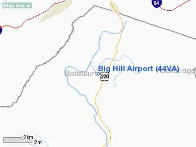
Location & QuickFacts
| FAA Information Effective: | 2008-09-25 |
| Airport Identifier: | 44VA |
| Airport Status: | Operational |
| Longitude/Latitude: | 079-48-40.1740W/37-43-52.4640N
-79.811159/37.731240 (Estimated) |
| Elevation: | 1620 ft / 493.78 m (Estimated) |
| Land: | 80 acres |
| From nearest city: | 4 nautical miles N of Eagle Rock, VA |
| Location: | Botetourt County, VA |
| Magnetic Variation: | 07W (1990) |
Owner & Manager
| Ownership: | Privately owned |
| Owner: | Clare D. Weidman |
| Address: | 18645 Botetourt Rd
Eagle Rock, VA 24085 |
| Phone number: | 540-968-0425 |
| Address: |
|
Airport Operations and Facilities
| Airport Use: | Private |
| Wind indicator: | Yes |
| Segmented Circle: | No |
| Control Tower: | No |
| Sectional chart: | Cincinnati |
| Region: | AEA - Eastern |
| Boundary ARTCC: | ZDC - Washington |
| Tie-in FSS: | DCA - Leesburg |
| FSS on Airport: | No |
| FSS Toll Free: | 1-800-WX-BRIEF |
Runway Information
Runway 03/21
| Dimension: | 2800 x 100 ft / 853.4 x 30.5 m |
| Surface: | TURF, |
| |
Runway 03 |
Runway 21 |
| Traffic Pattern: | Left | Left |
| Displaced threshold: | 300.00 ft | 300.00 ft |
| Obstruction: | 40 ft trees, 400.0 ft from runway | 40 ft trees, 500.0 ft from runway |
|
Radio Navigation Aids
| ID |
Type |
Name |
Ch |
Freq |
Var |
Dist |
| LW | NDB | Bushi | | 346.00 | 06W | 31.4 nm |
| VIT | NDB | Vinton | | 277.00 | 06W | 31.9 nm |
| CNQ | NDB | Callahan | | 379.00 | 05W | 32.7 nm |
| LY | NDB | Bojar | | 385.00 | 08W | 39.1 nm |
| TEC | NDB | Tech | | 368.00 | 06W | 42.3 nm |
| ODR | VOR | Woodrum | | 114.90 | 06W | 25.7 nm |
| RNL | VOR | Rainelle | | 116.60 | 04W | 49.5 nm |
| LWB | VOR/DME | Greenbrier | 107Y | 116.05 | 08W | 28.7 nm |
| MOL | VOR/DME | Montebello | 100X | 115.30 | 05W | 35.0 nm |
| ROA | VORTAC | Roanoke | 031X | 109.40 | 04W | 26.4 nm |
| LYH | VORTAC | Lynchburg | 029X | 109.20 | 05W | 39.6 nm |
Remarks
- VFR USE ONLY; PILOTS USING THIS ARPT ARE BRIEFED REGARDING THE OPNS OF HIGH SPEED MIL ACFT IN THE AREA & CONTACT MGR OF ROANOKE TWR FOR ESTABLISHED PROCEDURES PRIOR TO ANY OPNS.
Images and information placed above are from
http://www.airport-data.com/airport/44VA/
We thank them for the data!
| General Info
|
| Country |
United States
|
| State |
VIRGINIA
|
| FAA ID |
44VA
|
| Latitude |
37-43-52.464N
|
| Longitude |
079-48-40.174W
|
| Elevation |
1620 feet
|
| Near City |
EAGLE ROCK
|
We don't guarantee the information is fresh and accurate. The data may
be wrong or outdated.
For more up-to-date information please refer to other sources.
|
|


