 |
|
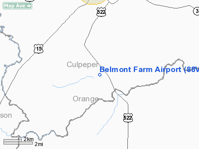
Location & QuickFacts
| FAA Information Effective: | 2008-09-25 |
| Airport Identifier: | 88VA |
| Airport Status: | Operational |
| Longitude/Latitude: | 077-59-31.0000W/38-22-27.0000N
-77.991944/38.374167 (Estimated) |
| Elevation: | 305 ft / 92.96 m (Estimated) |
| Land: | 19 acres |
| From nearest city: | 6 nautical miles S of Culpeper, VA |
| Location: | Culpeper County, VA |
| Magnetic Variation: | 09W (1990) |
Owner & Manager
| Ownership: | Privately owned |
| Owner: | Charles A Miller |
| Address: | 13490 Cedar Run Rd
Culpeper, VA 22701 |
| Phone number: | 540-825-3207 |
| Manager: | Charles A Miller |
| Address: | 13490 Cedar Run Rd
Culpeper, VA 22701 |
| Phone number: | 540-825-3207 |
Airport Operations and Facilities
| Airport Use: | Private |
| Segmented Circle: | No |
| Control Tower: | No |
| Sectional chart: | Washington |
| Region: | AEA - Eastern |
| Boundary ARTCC: | ZDC - Washington |
| Tie-in FSS: | DCA - Leesburg |
| FSS on Airport: | No |
| FSS Toll Free: | 1-800-WX-BRIEF |
Runway Information
Runway 04/22
| Dimension: | 2200 x 50 ft / 670.6 x 15.2 m |
| Surface: | TURF,
NE 500 FT CLSD FOR RETURFING. |
| |
Runway 04 |
Runway 22 |
| Traffic Pattern: | Left | Left |
| Obstruction: | 20 ft trees, 400.0 ft from runway | |
|
Radio Navigation Aids
| ID |
Type |
Name |
Ch |
Freq |
Var |
Dist |
| MSQ | NDB | Nailr | | 351.00 | 10W | 6.3 nm |
| CJR | NDB | Culpeper | | 252.00 | 09W | 11.3 nm |
| IQK | NDB | Louisa | | 382.00 | 09W | 22.2 nm |
| EZF | NDB | Shannon | | 237.00 | 10W | 26.3 nm |
| LUA | NDB | Caverns | | 245.00 | 09W | 29.9 nm |
| AZS | NDB | Azalea Park | | 336.00 | 08W | 33.1 nm |
| GDX | NDB | Goodwin Lake | | 227.00 | 08W | 35.7 nm |
| APH | NDB | A P Hill | | 396.00 | 10W | 35.9 nm |
| TZ | NDB | Cogan | | 364.00 | 10W | 43.0 nm |
| LJK | NDB | Ashey | | 280.00 | 09W | 43.5 nm |
| VBW | NDB | Bridgewater | | 241.00 | 07W | 45.7 nm |
| CSN | VORTAC | Casanova | 110X | 116.30 | 06W | 17.1 nm |
| GVE | VORTAC | Gordonsville | 103X | 115.60 | 06W | 23.0 nm |
| BRV | VORTAC | Brooke | 092X | 114.50 | 09W | 30.2 nm |
| LDN | VORTAC | Linden | 090X | 114.30 | 06W | 30.6 nm |
| AML | VORTAC | Armel | 082X | 113.50 | 08W | 41.7 nm |
Remarks
- PROVIDED DAYLIGHT OPERATIONS ONLY. NO IFR OPERATIONS. TRANSITIONAL SURFACES MAINTAINED TO A 7:1 SLOPE.
Images and information placed above are from
http://www.airport-data.com/airport/88VA/
We thank them for the data!
| General Info
|
| Country |
United States
|
| State |
VIRGINIA
|
| FAA ID |
88VA
|
| Latitude |
38-22-27.000N
|
| Longitude |
077-59-31.000W
|
| Elevation |
305 feet
|
| Near City |
CULPEPER
|
We don't guarantee the information is fresh and accurate. The data may
be wrong or outdated.
For more up-to-date information please refer to other sources.
|
|


