 |
|
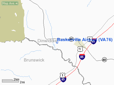
Location & QuickFacts
| FAA Information Effective: | 2008-09-25 |
| Airport Identifier: | VA76 |
| Airport Status: | Operational |
| Longitude/Latitude: | 077-46-17.9840W/36-59-15.5350N
-77.771662/36.987649 (Estimated) |
| Elevation: | 250 ft / 76.20 m (Estimated) |
| Land: | 0 acres |
| From nearest city: | 2 nautical miles W of Mc Kenney, VA |
| Location: | Dinwiddie County, VA |
| Magnetic Variation: | 08W (1985) |
Owner & Manager
| Ownership: | Privately owned |
| Owner: | A. T. Baskerville |
| Address: | 206 Harper Dr
Orange, VA 22960 |
| Phone number: | 703-672-3155 |
| Manager: | A. T. Baskerville |
| Address: | 206 Harper Drive
Orange, VA 22960 |
| Phone number: | 703-672-3155 |
Airport Operations and Facilities
| Airport Use: | Private |
| Wind indicator: | No |
| Segmented Circle: | No |
| Control Tower: | No |
| Landing fee charge: | No |
| Sectional chart: | Washington |
| Region: | AEA - Eastern |
| Boundary ARTCC: | ZDC - Washington |
| Tie-in FSS: | DCA - Leesburg |
| FSS on Airport: | No |
| FSS Toll Free: | 1-800-WX-BRIEF |
Airport Services
| Airframe Repair: | NONE |
| Power Plant Repair: | NONE |
Runway Information
Runway 09/27
| Dimension: | 1200 x 60 ft / 365.8 x 18.3 m |
| Surface: | TURF, |
| |
Runway 09 |
Runway 27 |
| Traffic Pattern: | Left | Left |
|
Radio Navigation Aids
| ID |
Type |
Name |
Ch |
Freq |
Var |
Dist |
| PTB | NDB | Petersburg | | 284.00 | 08W | 12.8 nm |
| BKT | NDB | Blackstone | | 326.00 | 09W | 15.6 nm |
| MBV | NDB | Mecklenburg/dcmsnd | | 356.00 | 08W | 22.4 nm |
| CF | NDB | Pubbs | | 392.00 | 09W | 25.8 nm |
| AEA | NDB | Jones | | 373.00 | 09W | 26.2 nm |
| ELQ | NDB | Emporia | | 261.00 | 10W | 27.8 nm |
| RZZ | NDB | Rapids | | 407.00 | 08W | 33.0 nm |
| AKQ | NDB | Wakefield | | 274.00 | 09W | 37.0 nm |
| FVX | NDB | Farmville | | 367.00 | 07W | 38.7 nm |
| LJK | NDB | Ashey | | 280.00 | 09W | 49.2 nm |
| LVL | VORTAC | Lawrenceville | 076X | 112.90 | 08W | 12.0 nm |
| FAK | VORTAC | Flat Rock | 080X | 113.30 | 06W | 32.6 nm |
| HPW | VORTAC | Hopewell | 057X | 112.00 | 06W | 37.5 nm |
| RIC | VORTAC | Richmond | 088X | 114.10 | 09W | 37.7 nm |
| FKN | VORTAC | Franklin | 043X | 110.60 | 09W | 40.1 nm |
Images and information placed above are from
http://www.airport-data.com/airport/VA76/
We thank them for the data!
| General Info
|
| Country |
United States
|
| State |
VIRGINIA
|
| FAA ID |
VA76
|
| Latitude |
36-59-15.535N
|
| Longitude |
077-46-17.984W
|
| Elevation |
250 feet
|
| Near City |
MC KENNEY
|
We don't guarantee the information is fresh and accurate. The data may
be wrong or outdated.
For more up-to-date information please refer to other sources.
|
|


