 |
|
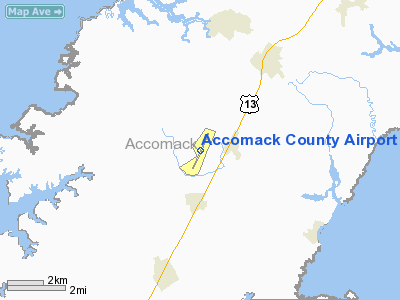
Location & QuickFacts
| FAA Information Effective: | 2008-09-25 |
| Airport Identifier: | MFV |
| Airport Status: | Operational |
| Longitude/Latitude: | 075-45-39.8000W/37-38-48.8000N
-75.761056/37.646889 (Estimated) |
| Elevation: | 47 ft / 14.33 m (Surveyed) |
| Land: | 100 acres |
| From nearest city: | 1 nautical miles W of Melfa, VA |
| Location: | Accomack County, VA |
| Magnetic Variation: | 11W (2000) |
Owner & Manager
| Ownership: | Publicly owned |
| Owner: | Accomack County Airport Commission |
| Address: | 29194 Parkway North
Melfa, VA 23410 |
| Phone number: | 757-787-4600 |
| Manager: | Barbara Haxter |
| Address: | 29194 Parkway North
Melfa, VA 23410 |
| Phone number: | 757-787-4600 |
Airport Operations and Facilities
| Airport Use: | Open to public |
| Wind indicator: | Yes |
| Segmented Circle: | Yes |
| Control Tower: | No |
| Lighting Schedule: | DUSK-DAWN
MIRL RY 03/21 PRESET LOW INTST; INCR INTST & ACTVT REIL RYS 03 & 21 - CTAF. |
| Beacon Color: | Clear-Green (lighted land airport) |
| Landing fee charge: | No |
| Sectional chart: | Washington |
| Region: | AEA - Eastern |
| Boundary ARTCC: | ZDC - Washington |
| Tie-in FSS: | DCA - Leesburg |
| FSS on Airport: | No |
| FSS Toll Free: | 1-800-WX-BRIEF |
| NOTAMs Facility: | MFV (NOTAM-d service avaliable) |
| Federal Agreements: | NX
SUBJECT TO EXCLUSIVE RIGHTS PROHIBITION OF SECTION 308A(CONSTRUCTED BY BPR). |
Airport Communications
| CTAF: | 122.800 |
| Unicom: | 122.800 |
Airport Services
| Fuel available: | 100LLA+
SELF-SERVE FUEL (100LL AND A+) AVAILABLE 24HRS |
| Airframe Repair: | NONE |
| Power Plant Repair: | NONE |
| Bottled Oxygen: | NONE |
| Bulk Oxygen: | NONE |
Runway Information
Runway 03/21
| Dimension: | 5000 x 100 ft / 1524.0 x 30.5 m |
| Surface: | ASPH, Good Condition |
| Weight Limit: | Single wheel: 26000 lbs. |
| Edge Lights: | Medium |
| |
Runway 03 |
Runway 21 |
| Longitude: | 075-45-51.8991W | 075-45-27.6249W |
| Latitude: | 37-38-26.0087N | 37-39-11.5203N |
| Elevation: | 46.00 ft | 47.00 ft |
| Alignment: | 23 | 127 |
| ILS Type: | LOCALIZER
| |
| Traffic Pattern: | Left | Left |
| Markings: | Non-precision instrument, Good Condition | Non-precision instrument, Good Condition |
| Crossing Height: | 40.00 ft | 40.00 ft |
| VASI: | 2-light PAPI on left side | 2-light PAPI on left side |
| Visual Glide Angle: | 3.00° | 3.00° |
| Runway End Identifier: | Yes | Yes |
| Obstruction: | 57 ft tree, 1811.0 ft from runway, 452 ft right of centerline, 28:1 slope to clear | 73 ft trees, 1682.0 ft from runway, 327 ft right of centerline, 20:1 slope to clear
ROAD 200' RIGHT AND PARALLEL TO RWY. |
|
Radio Navigation Aids
| ID |
Type |
Name |
Ch |
Freq |
Var |
Dist |
| BDB | NDB | Accomack | | 336.00 | 11W | 4.9 nm |
| PJS | NDB | Henry | | 375.00 | 09W | 46.7 nm |
| NHK | NDB | Patuxent | | 400.00 | 10W | 49.0 nm |
| LFI | TACAN | Langley | 070X | | 10W | 44.2 nm |
| NGU | TACAN | Chambers | 048X | | 10W | 49.1 nm |
| CCV | VORTAC | Cape Charles | 059X | 112.20 | 10W | 21.2 nm |
| SWL | VORTAC | Snow Hill | 071X | 112.40 | 08W | 28.4 nm |
| SBY | VORTAC | Salisbury | 049X | 111.20 | 12W | 43.6 nm |
| HCM | VORTAC | Harcum | 025X | 108.80 | 07W | 46.8 nm |
| PXT | VORTAC | Patuxent | 123X | 117.60 | 10W | 49.0 nm |
Remarks
- GCO AVBL ON FREQ 135.075 THRU ORF CLEARANCE DELIVERY.
- DEER ON & INVOF ARPT.
- IN OPERATION PRIOR 1959
Images and information placed above are from
http://www.airport-data.com/airport/MFV/
We thank them for the data!
| General Info
|
| Country |
United States
|
| State |
VIRGINIA
|
| FAA ID |
MFV
|
| Latitude |
37-38-48.800N
|
| Longitude |
075-45-39.800W
|
| Elevation |
47 feet
|
| Near City |
MELFA
|
We don't guarantee the information is fresh and accurate. The data may
be wrong or outdated.
For more up-to-date information please refer to other sources.
|
|


