 |
|
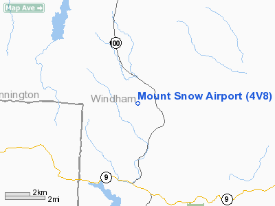
Location & QuickFacts
| FAA Information Effective: | 2008-09-25 |
| Airport Identifier: | 4V8 |
| Airport Status: | Operational |
| Longitude/Latitude: | 072-51-56.3530W/42-55-37.6880N
-72.865654/42.927136 (Estimated) |
| Elevation: | 1953 ft / 595.27 m (Surveyed) |
| Land: | 35 acres |
| From nearest city: | 1 nautical miles SW of West Dover, VT |
| Location: | Windham County, VT |
| Magnetic Variation: | 15W (1985) |
Owner & Manager
| Ownership: | Privately owned |
| Owner: | Airport Development, Inc |
| Address: | Po Box 8
West Dover, VT 05356 |
| Phone number: | 802-464-2196 |
| Manager: | Robert North
ALSO TIM FRANCESCHETTI. |
| Address: | Po Box 8
West Dover, VT 05356 |
| Phone number: | 617-803-4227
OR 802-464-2196 |
Airport Operations and Facilities
| Airport Use: | Open to public |
| Wind indicator: | Yes |
| Segmented Circle: | No |
| Control Tower: | No |
| Lighting Schedule: | DUSK-0200 |
| Landing fee charge: | Yes |
| Sectional chart: | New York |
| Region: | ANE - New England |
| Boundary ARTCC: | ZBW - Boston |
| Tie-in FSS: | BTV - Burlington |
| FSS Toll Free: | 1-800-WX-BRIEF |
| NOTAMs Facility: | BTV (NOTAM-d service avaliable) |
Airport Communications
| CTAF: | 122.800 |
| Unicom: | 122.800 |
Airport Services
Runway Information
Runway 01/19
| Dimension: | 2650 x 75 ft / 807.7 x 22.9 m |
| Surface: | ASPH, Poor Condition
AVG PCI 12.83. RWY 01/19 PAVEMENT HAS BLOCKING, TRAVERSE CRACKING, RUTTING AND LOOSE ROCKS ON RUNWAY. |
| Edge Lights: | Non-standard lighting system
NSTD LATERAL LIRL; THLD LIGHTS ALL GREEN. |
| |
Runway 01 |
Runway 19 |
| Longitude: | 072-51-53.2750W | 072-51-59.3800W |
| Latitude: | 42-55-24.8250N | 42-55-50.6150N |
| Elevation: | 1948.00 ft | 1950.00 ft |
| Alignment: | 127 | 127 |
| Traffic Pattern: | Left | Left |
| Markings: | Non-precision instrument, Fair Condition | Basic, Fair Condition |
| Obstruction: | 61 ft trees, 662.0 ft from runway, 54 ft right of centerline, 7:1 slope to clear | 81 ft trees, 953.0 ft from runway, 174 ft left of centerline, 9:1 slope to clear |
|
Radio Navigation Aids
| ID |
Type |
Name |
Ch |
Freq |
Var |
Dist |
| PSF | FAN MARKER | Abyss | | | 13W | 32.2 nm |
| R | FAN MARKER | Chitt | | | 14W | 42.9 nm |
| SXD | NDB | Springfield | | 265.00 | 15W | 24.0 nm |
| DXT | NDB | Dalton | | 370.00 | 15W | 30.5 nm |
| ORE | NDB | Orange | | 205.00 | 15W | 33.4 nm |
| CNH | NDB | Claremont | | 233.00 | 16W | 34.3 nm |
| IVV | NDB | White River | | 379.00 | 16W | 41.9 nm |
| DYO | NDB | Smuto | | 221.00 | 15W | 47.0 nm |
| HEU | NDB | Hunter | | 356.00 | 14W | 47.3 nm |
| CAM | VOR/DME | Cambridge | 097X | 115.00 | 14W | 21.4 nm |
| RUT | VOR/DME | Rutland | 47X | 111.00 | 15W | 36.2 nm |
| CTR | VOR/DME | Chester | 098X | 115.10 | 13W | 38.4 nm |
| EEN | VORTAC | Keene | 031X | 109.40 | 14W | 26.5 nm |
| GFL | VORTAC | Glens Falls | 039X | 110.20 | 14W | 41.1 nm |
| GDM | VORTAC | Gardner | 043X | 110.60 | 14W | 42.4 nm |
| ALB | VORTAC | Albany | 100X | 115.30 | 13W | 42.7 nm |
| CEF | VORTAC | Westover | 87X | 114.00 | 14W | 46.4 nm |
| BAF | VORTAC | Barnes | 077X | 113.00 | 14W | 46.5 nm |
| ALB | VOT | Albany County | | 108.20 | | 43.6 nm |
Remarks
- NO LINE OF SIGHT BTN RY ENDS.
- OLD X MARKINGS DENOTING CLSD RY SHOWING THROUGH ASPH COATING.
- PRIMARY SURFACE AREA CLUTTERED WITH TREES
- TRANSITIONAL AREAS CLUTTERED WITH TREES.
- NO OBJECTION.
Images and information placed above are from
http://www.airport-data.com/airport/4V8/
We thank them for the data!
| General Info
|
| Country |
United States
|
| State |
VERMONT
|
| FAA ID |
4V8
|
| Latitude |
42-55-37.688N
|
| Longitude |
072-51-56.353W
|
| Elevation |
1953 feet
|
| Near City |
WEST DOVER
|
We don't guarantee the information is fresh and accurate. The data may
be wrong or outdated.
For more up-to-date information please refer to other sources.
|
|


