 |
|
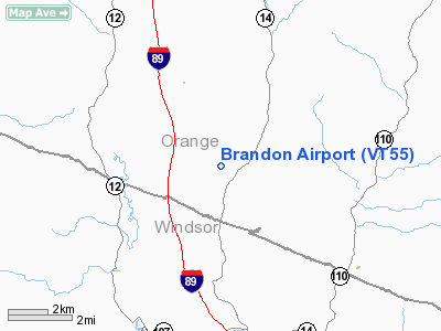
Location & QuickFacts
| FAA Information Effective: | 2008-09-25 |
| Airport Identifier: | VT55 |
| Airport Status: | Operational |
| Longitude/Latitude: | 072-34-58.3640W/43-54-04.2370N
-72.582879/43.901177 (Estimated) |
| Elevation: | 710 ft / 216.41 m (Surveyed) |
| Land: | 20 acres |
| From nearest city: | 3 nautical miles SE of Randolph, VT |
| Location: | Orange County, VT |
| Magnetic Variation: | 16W (1985) |
Owner & Manager
| Ownership: | Privately owned |
| Owner: | Carl Brandon |
| Address: | Rd 1, Box 453
Randolph Ctr, VT 05061 |
| Phone number: | 802-728-9947 |
| Manager: | Carl Brandon |
| Address: | Rd 1, Box 453
Randolph Ctr, VT 05061 |
| Phone number: | 802-728-9947 |
Airport Operations and Facilities
| Airport Use: | Private
PERSONAL USE. |
| Wind indicator: | Yes |
| Segmented Circle: | No |
| Control Tower: | No |
| Sectional chart: | New York |
| Region: | ANE - New England |
| Boundary ARTCC: | ZBW - Boston |
| Tie-in FSS: | BTV - Burlington |
| FSS on Airport: | No |
| FSS Toll Free: | 1-800-WX-BRIEF |
Runway Information
Runway 17/35
| Dimension: | 1300 x 25 ft / 396.2 x 7.6 m |
| Surface: | TURF, |
| |
Runway 17 |
Runway 35 |
| Traffic Pattern: | Left | Left |
| Obstruction: | 90 ft trees, 160.0 ft from runway | 50 ft trees, 440.0 ft from runway |
|
Radio Navigation Aids
| ID |
Type |
Name |
Ch |
Freq |
Var |
Dist |
| R | FAN MARKER | Chitt | | | 14W | 23.3 nm |
| MPV | FAN MARKER | Brook | | | | 25.4 nm |
| DYO | NDB | Smuto | | 221.00 | 15W | 20.0 nm |
| IVV | NDB | White River | | 379.00 | 16W | 21.1 nm |
| LAH | NDB | Hanover | | 276.00 | 15W | 21.3 nm |
| VKN | NDB | Mount Mansfield | | 268.00 | 16W | 29.6 nm |
| CNH | NDB | Claremont | | 233.00 | 16W | 33.3 nm |
| SXD | NDB | Springfield | | 265.00 | 15W | 37.9 nm |
| JRV | NDB | Morrisville/stowe | | 375.00 | 16W | 40.7 nm |
| LLX | NDB | Lyndonville | | 353.00 | 16W | 43.4 nm |
| GMA | NDB | Mahn | | 386.00 | 17W | 47.6 nm |
| MPV | VOR/DME | Montpelier | 045X | 110.80 | 16W | 12.5 nm |
| LEB | VOR/DME | Lebanon | 084X | 113.70 | 15W | 20.8 nm |
| RUT | VOR/DME | Rutland | 47X | 111.00 | 15W | 27.6 nm |
| BTV | VORTAC | Burlington | 122X | 117.50 | 15W | 39.5 nm |
| BTV | VOT | Burlington Intl | | 109.00 | | 41.9 nm |
Remarks
Images and information placed above are from
http://www.airport-data.com/airport/VT55/
We thank them for the data!
| General Info
|
| Country |
United States
|
| State |
VERMONT
|
| FAA ID |
VT55
|
| Latitude |
43-54-04.237N
|
| Longitude |
072-34-58.364W
|
| Elevation |
710 feet
|
| Near City |
RANDOLPH
|
We don't guarantee the information is fresh and accurate. The data may
be wrong or outdated.
For more up-to-date information please refer to other sources.
|
|


