 |
|
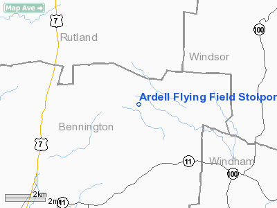
Ardell Flying Field Stolport |
Location & QuickFacts
| FAA Information Effective: | 2008-09-25 |
| Airport Identifier: | VT59 |
| Airport Status: | Operational |
| Longitude/Latitude: | 072-54-39.0000W/43-16-40.0000N
-72.910833/43.277778 (Estimated) |
| Elevation: | 1919 ft / 584.91 m (Estimated) |
| Land: | 0 acres |
| From nearest city: | 10 nautical miles NE of Manchester, VT |
| Location: | Bennington County, VT |
| Magnetic Variation: | 15W (1995) |
Owner & Manager
| Ownership: | Privately owned |
| Owner: | Richard Ardell |
| Address: | P.o. Box 200
Peru, VT 05152 |
| Phone number: | 802-824-6120 |
| Manager: | Richard Ardell
OTHER CONTACT; BARBARA HIDELL 802-824-5022 |
| Address: | P.o. Box 200
Peru, VT 05152 |
| Phone number: | 802-824-6120 |
Airport Operations and Facilities
| Airport Use: | Private |
| Segmented Circle: | No |
| Control Tower: | No |
| Sectional chart: | New York |
| Region: | ANE - New England |
| Boundary ARTCC: | ZBW - Boston |
| Tie-in FSS: | BTV - Burlington |
| FSS on Airport: | No |
| FSS Toll Free: | 1-800-WX-BRIEF |
Runway Information
Runway 18/36
| Dimension: | 1900 x 175 ft / 579.1 x 53.3 m |
| Surface: | TURF, |
| |
Runway 18 |
Runway 36 |
| Traffic Pattern: | Left | Right |
|
Radio Navigation Aids
| ID |
Type |
Name |
Ch |
Freq |
Var |
Dist |
| R | FAN MARKER | Chitt | | | 14W | 21.8 nm |
| SXD | NDB | Springfield | | 265.00 | 15W | 14.2 nm |
| VWD | NDB | Mount Snow | | 224.00 | 15W | 21.1 nm |
| CNH | NDB | Claremont | | 233.00 | 16W | 24.2 nm |
| IVV | NDB | White River | | 379.00 | 16W | 25.8 nm |
| DYO | NDB | Smuto | | 221.00 | 15W | 25.8 nm |
| LAH | NDB | Hanover | | 276.00 | 15W | 40.9 nm |
| DXT | NDB | Dalton | | 370.00 | 15W | 49.8 nm |
| RUT | VOR/DME | Rutland | 47X | 111.00 | 15W | 15.1 nm |
| CAM | VOR/DME | Cambridge | 097X | 115.00 | 14W | 25.5 nm |
| LEB | VOR/DME | Lebanon | 084X | 113.70 | 15W | 38.7 nm |
| GFL | VORTAC | Glens Falls | 039X | 110.20 | 14W | 30.9 nm |
| EEN | VORTAC | Keene | 031X | 109.40 | 14W | 39.8 nm |
Remarks
- PRVDD VFR; STOL ACFT ONLY.
Images and information placed above are from
http://www.airport-data.com/airport/VT59/
We thank them for the data!
| General Info
|
| Country |
United States
|
| State |
VERMONT
|
| FAA ID |
VT59
|
| Latitude |
43-16-40.000N
|
| Longitude |
072-54-39.000W
|
| Elevation |
1900 feet
|
| Near City |
MANCHESTER
|
We don't guarantee the information is fresh and accurate. The data may
be wrong or outdated.
For more up-to-date information please refer to other sources.
|
|


