 |
|
Coordinates: 40°26′27″N 109°30′36″W / 40.44083°N 109.51°W / 40.44083; -109.51
Vernal Regional Airport
Vernal - Uintah County Airport |
 |
| IATA: VEL – ICAO: KVEL – FAA LID: VEL |
| Summary |
| Airport type |
Public |
| Owner |
Uintah County & Vernal City |
| Serves |
Vernal, Utah |
| Elevation AMSL |
5,278 ft / 1,609 m |
| Runways |
| Direction |
Length |
Surface |
| ft |
m |
| 16/34 |
6,201 |
1,890 |
Asphalt |
| 7/25 |
4,108 |
1,252 |
Asphalt |
| Statistics (2006) |
| Aircraft operations |
9,950 |
| Based aircraft |
34 |
| Source: Federal Aviation Administration |
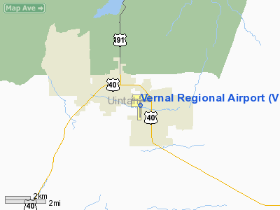
Vernal Regional Airport (IATA: VEL, ICAO: KVEL, FAA LID: VEL), formerly known as Vernal - Uintah County Airport, is a public airport located one mile (2 km) southeast of the central business district of Vernal, a city in Uintah County, Utah, United States. It is owned by Uintah County and Vernal City. It is mostly used for general aviation, but is served by one commercial airline. Service is subsidized by the Essential Air Service program.
Air Midwest, operating as US Airways Express, commenced service on July 2, 2006, with flights to Salt Lake City International Airport. Previously, scheduled service was provided by Salmon Air with flights to Salt Lake City. Before Salmon Air provided service, SkyWest Airlines provided service between 1984 and 2001 with flights to Salt Lake City International Airport. A route map from 1948 showed that Challenger Airlines was proposing service via Salt Lake City and route maps for Frontier Airlines (1950-1986) show that after it acquired Challenger Airlines, it provided service between 1950-1978 via Salt Lake City and Rock Springs, Wyoming. By January 2008, Great Lakes Aviation will replace Air Midwest, with flights to Denver. According to United Airlines website they provide service to Vernal through partnership with Great Lakes Airlines with flights to Denver.
As per Federal Aviation Administration records, the airport had 1,074 passenger boardings (enplanements) in calendar year 2005. According to the FAA's National Plan of Integrated Airport Systems for 2007-2011, Vernal Regional Airport is a general aviation airport because a commercial service classification requires at least 2,500 passenger boardings per year. Facilities and aircraft
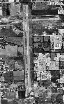
Vernal Regional Airport covers an area of 254 acres (103 ha) which contains two asphalt paved runways: 16/34 measuring 6,201 x 150 ft (1,890 x 46 m) and 7/25 measuring 4,108 x 60 ft (1,252 x 18 m).
For the 12-month period ending May 31, 2006, the airport had 9,950 aircraft operations, an average of 27 per day: 75% general aviation, 15% scheduled commercial and 10% air taxi. There are 34 aircraft based at this airport: 71% single engine, 24% ultralight, 3% multi-engine and 3% glider.
Airlines and destinations
| Airlines |
Destinations |
| Great Lakes Airlines |
Denver |
The above content comes from Wikipedia and is published under free licenses – click here to read more.
Location & QuickFacts
| FAA Information Effective: | 2008-09-25 |
| Airport Identifier: | VEL |
| Airport Status: | Operational |
| Longitude/Latitude: | 109-30-35.7000W/40-26-27.3000N
-109.509917/40.440917 (Estimated) |
| Elevation: | 5278 ft / 1608.73 m (Surveyed) |
| Land: | 254 acres |
| From nearest city: | 1 nautical miles SE of Vernal, UT |
| Location: | Uintah County, UT |
| Magnetic Variation: | 13E (2000) |
Owner & Manager
| Ownership: | Publicly owned |
| Owner: | Uintah Co And Vernal City |
| Address: | 825 South 500 E
Vernal, UT 84078 |
| Phone number: | 435-789-3400 |
| Manager: | Philip Oviatt |
| Address: | 825 South 500 E
Vernal, UT 84078 |
| Phone number: | 435-789-3400 |
Airport Operations and Facilities
| Airport Use: | Open to public |
| Wind indicator: | Yes |
| Segmented Circle: | Yes |
| Control Tower: | No |
| Lighting Schedule: | DUSK-DAWN
ACTVT MIRL RYS 07/25 & 16/34, REIL RYS 07 & 25 AND 16 & 34, AND PAPI RYS 07 & 25 - CTAF. |
| Beacon Color: | Clear-Green (lighted land airport) |
| Landing fee charge: | No |
| Sectional chart: | Salt Lake City |
| Region: | ANM - Northwest Mountain |
| Boundary ARTCC: | ZLC - Salt Lake City |
| Tie-in FSS: | CDC - Cedar City |
| FSS on Airport: | No |
| FSS Toll Free: | 1-800-WX-BRIEF |
| NOTAMs Facility: | VEL (NOTAM-d service avaliable) |
| Certification type/date: | III A S 06/20
24 HR PPR REQUIRED FOR ACR OPS OVER 30 PSGR SEATS CTC AMGR 435-789-3400. RY 07/25 NOT AVBL FOR ACR USE. |
| Federal Agreements: | NGY |
Airport Communications
| CTAF: | 122.700 |
| Unicom: | 122.700 |
Airport Services
| Fuel available: | 100LLA |
| Airframe Repair: | MAJOR |
| Power Plant Repair: | MAJOR |
| Bulk Oxygen: | HIGH/LOW |
Runway Information
Runway 07/25
| Dimension: | 4108 x 60 ft / 1252.1 x 18.3 m |
| Surface: | ASPH, Good Condition |
| Weight Limit: | Single wheel: 12500 lbs. |
| Edge Lights: | Medium |
| |
Runway 07 |
Runway 25 |
| Longitude: | 109-30-59.1898W | 109-30-06.0716W |
| Latitude: | 40-26-40.8977N | 40-26-41.4156N |
| Elevation: | 5278.00 ft | 5233.00 ft |
| Alignment: | 89 | 127 |
| Traffic Pattern: | Left | Left |
| Markings: | Basic, Good Condition | Basic, Good Condition |
| Crossing Height: | 24.00 ft | 23.00 ft |
| VASI: | 2-light PAPI on left side | 2-light PAPI on left side |
| Visual Glide Angle: | 3.00° | 3.00° |
| Runway End Identifier: | Yes | Yes |
| Obstruction: | 74 ft tree, 771.0 ft from runway, 376 ft right of centerline, 7:1 slope to clear | 43 ft tree, 602.0 ft from runway, 195 ft right of centerline, 9:1 slope to clear |
|
Runway 16/34
| Dimension: | 6201 x 150 ft / 1890.1 x 45.7 m |
| Surface: | ASPH, Fair Condition |
| Weight Limit: | Single wheel: 45000 lbs.
Dual wheel: 55000 lbs. |
| Edge Lights: | Medium |
| |
Runway 16 |
Runway 34 |
| Longitude: | 109-30-38.4416W | 109-30-37.0685W |
| Latitude: | 40-26-48.6957N | 40-25-47.4447N |
| Elevation: | 5262.00 ft | 5265.00 ft |
| Alignment: | 127 | 127 |
| Traffic Pattern: | Left | Left |
| Markings: | Non-precision instrument, Fair Condition | Non-precision instrument, Fair Condition |
| Crossing Height: | 54.00 ft | 43.00 ft |
| VASI: | 4-light PAPI on left side | 4-light PAPI on left side |
| Visual Glide Angle: | 3.00° | 3.00° |
| Runway End Identifier: | Yes | Yes |
| Obstruction: | 33 ft pole, 586.0 ft from runway, 367 ft left of centerline, 11:1 slope to clear | 44 ft trees, 1094.0 ft from runway, 203 ft right of centerline, 20:1 slope to clear |
|
Radio Navigation Aids
| ID |
Type |
Name |
Ch |
Freq |
Var |
Dist |
| VEL | VOR/DME | Vernal | 019X | 108.20 | 15E | 3.8 nm |
| MTU | VORTAC | Myton | 074X | 112.70 | 14E | 33.3 nm |
Images and information placed above are from
http://www.airport-data.com/airport/VEL/
We thank them for the data!
| General Info
|
| Country |
United States
|
| State |
UTAH
|
| FAA ID |
VEL
|
| Latitude |
40-26-27.300N
|
| Longitude |
109-30-35.700W
|
| Elevation |
5278 feet
|
| Near City |
VERNAL
|
We don't guarantee the information is fresh and accurate. The data may
be wrong or outdated.
For more up-to-date information please refer to other sources.
|
|


