 |
|
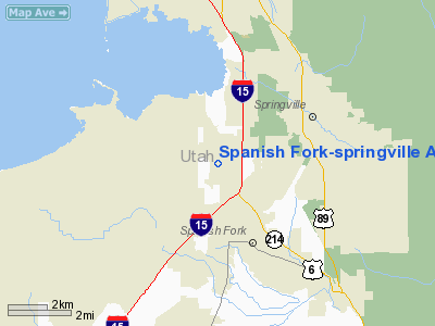
Spanish Fork-springville Airport |
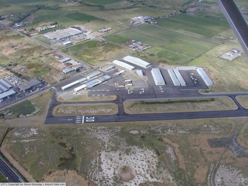 |
(Click on the photo to enlarge) |
Location & QuickFacts
| FAA Information Effective: | 2008-09-25 |
| Airport Identifier: | U77 |
| Airport Status: | Operational |
| Longitude/Latitude: | 111-39-40.7250W/40-08-29.8370N
-111.661312/40.141621 (Estimated) |
| Elevation: | 4529 ft / 1380.44 m (Estimated) |
| Land: | 345 acres |
| From nearest city: | 2 nautical miles NW of Spanish Fork, UT |
| Location: | Utah County, UT |
| Magnetic Variation: | 14E (1985) |
Owner & Manager
| Ownership: | Publicly owned |
| Owner: | Spanish Fork & Springville
CITIES OF SPANISH FORK & SPRINGVILLE. |
| Address: | 2050 N. 300 W
Spanish Fork, UT 84660 |
| Phone number: | 801-798-9888 |
| Manager: | Floyd Richey |
| Address: | 2050 North 300 West
Spanish Fork, UT 84660 |
| Phone number: | 801-319-2044 |
Airport Operations and Facilities
| Airport Use: | Open to public |
| Wind indicator: | Yes |
| Segmented Circle: | Yes |
| Control Tower: | No |
| Lighting Schedule: | DUSK-DAWN
ACTVT MIRL RWY 12/30 - 122.9 5 TIMES. |
| Beacon Color: | Clear-Green (lighted land airport) |
| Landing fee charge: | No |
| Sectional chart: | Salt Lake City |
| Region: | ANM - Northwest Mountain |
| Boundary ARTCC: | ZLC - Salt Lake City |
| Tie-in FSS: | CDC - Cedar City |
| FSS on Airport: | No |
| FSS Toll Free: | 1-800-WX-BRIEF |
| NOTAMs Facility: | CDC (NOTAM-d service avaliable) |
| Federal Agreements: | NGY |
Airport Communications
Airport Services
| Fuel available: | 100LLA
SELF SERVE 100LL AVAILABLE ANYTIME WITH CREDIT CARD. |
| Airframe Repair: | MAJOR |
| Power Plant Repair: | MAJOR |
| Bottled Oxygen: | NONE |
| Bulk Oxygen: | HIGH/LOW |
Runway Information
Runway 12/30
| Dimension: | 5700 x 100 ft / 1737.4 x 30.5 m |
| Surface: | ASPH, Fair Condition |
| Weight Limit: | Single wheel: 24000 lbs. |
| Edge Lights: | Medium |
| |
Runway 12 |
Runway 30 |
| Traffic Pattern: | Left | Right |
| Markings: | Basic, Fair Condition | Basic, Fair Condition |
| Crossing Height: | 40.00 ft | 40.00 ft |
| Displaced threshold: | 0.00 ft | 290.00 ft |
| VASI: | 4-light PAPI on left side | 4-light PAPI on left side |
| Visual Glide Angle: | 3.00° | 3.00° |
| Obstruction: | 15 ft road, 500.0 ft from runway, 20:1 slope to clear | 16 ft road, 350.0 ft from runway, 9:1 slope to clear
RWY 30 APCH SLOPE 40:1 TO DSPLCD THR. |
|
Radio Navigation Aids
| ID |
Type |
Name |
Ch |
Freq |
Var |
Dist |
| TVY | NDB | Tooele | | 371.00 | 13E | 42.2 nm |
| PVU | VOR/DME | Provo | 021X | 108.40 | 15E | 5.2 nm |
| FFU | VORTAC | Fairfield | 113X | 116.60 | 16E | 15.1 nm |
| TCH | VORTAC | Wasatch | 115X | 116.80 | 16E | 45.0 nm |
| SLC | VOT | Salt Lake City | | 111.00 | | 32.5 nm |
Remarks
- DEER ON & INVOF ARPT.
- NOISE ABATEMENT PROCEDURES IN EFFECT. CALL AMGR 801-798-9888.
Images and information placed above are from
http://www.airport-data.com/airport/U77/
We thank them for the data!
| General Info
|
| Country |
United States
|
| State |
UTAH
|
| FAA ID |
U77
|
| Latitude |
40-08-29.837N
|
| Longitude |
111-39-40.725W
|
| Elevation |
4529 feet
|
| Near City |
SPANISH FORK
|
We don't guarantee the information is fresh and accurate. The data may
be wrong or outdated.
For more up-to-date information please refer to other sources.
|
|


