|
 |
|
||||
|
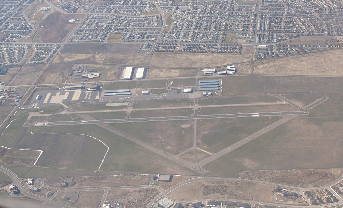
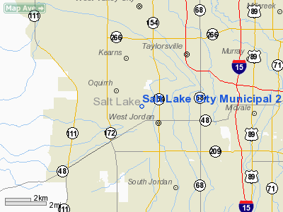
South Valley Regional Airport (FAA LID: U42) is a public airport located in West Jordan, seven miles (11 km) southwest of Salt Lake City, Utah. It is the primary general aviation airport in the area, to offload many flights from Salt Lake City International Airport, the larger, international airport nearby which is predomantly used by commercial airline carriers. FacilitiesThe airport was formerly named Salt Lake City Municipal 2 Airport. In an effort to reduce confusion with the nearby International Airport, the field was recently re-named. The airport is one of three owned and operated by Salt Lake City Department of Airports, the other two being Salt Lake City International and Tooele Valley Airport. There is a single Fixed Based Operator (FBO) onsite, Air Center of Salt Lake, as well as a maintenance facility operated by Alta Aircraft Maintenance. Two flight schools, one operated by the FBO, and the other one by Utah Helicopter Flight Academy are located at the airport as well. The airport also is a training base for the Utah Army National Guard, which operates Apache and Blackhawk helicopters. HistoryOpened on 1 May 1942, South Valley Regional Airport was known during World War II as Kearns Army Airfield, and provided operational training for units and personnel during World War II as part of Army Air Forces Training Command. It was part of the larger Kearns Army Air Base, which was a major Air Force Basic and Technical training facility, as well as an Overseas Replacement Depot for personnel being reassigned to one of the combat zones. Kearns Army AirfieldKearns AAF was the operational airfield for Kearns Army Air Base. Initially part of the Army Air Force Training Command, it was reassigned to Second Air Force on 1 October 1943. Although part of the overall air base, it was operated as a separate facility by Second AF. The mission of Kearns AAF was primary aircrew training of newly-formed B-24 Liberator Heavy Bombardment Groups. From Kearns, the units then were reassigned to other airfields for more advanced training. Units which were trained at the airfield were:
.* Transferred to Wendover Field, Utah for training In January 1944, Kearns AAF began performing personnel replacement training, rather than group training. In April, ground echelon training for B-24 support personnel was ended, and the Airfield was transferred back to Army Air Forces Training Command. Kearns Army AirbaseIn consequence of the attack on Pearl Harbor, the United States Army Air Force determined that large training bases should be located far inland so that they would not be vulnerable to coastal attack. Almost equidistant from the three major west coast ports of Seattle, San Francisco, and Los Angeles and about halfway between Canada and Mexico, northern Utah sat in an ideal location, situated as to be readily defensible and easily accessible by railroad, automobile, and airplane. Colonel E.G. Thomas combed the area in early 1942 searching for good drainage, an accessible water supply, and a climate friendly to aircraft landings for an air corps training base. Colonel Thomas recommended a 5,450-acre dry farming area about fourteen miles (21 km) west of Salt Lake City. The Army Air Force proceeded rapidly with construction, intending the base to be a temporary unit. From 7 April to 22 May 1942, the base grew with the installation of water mains, sewage systems, streets, tar-paper buildings, and electrical systems capable of supporting 30,000 to 70,000 people. The Air Force also built a railroad spur from the Denver and Rio Grande Railroad as well as a fence around the base. By 21 August, all the barracks had been completed at an estimated total cost of $17 million. Upon completion, the base boasted 1,700,000 square feet (158,000 m) of warehouse space, 926 tarpaper buildings, theaters, gymnasiums, fire stations, recreation fields, chapels, barbershops, a ten-wing hospital, a railroad station, a post office, a library, a cold storage plant, and a bank. Furthermore, 25,000 trees, shrubs, and grass were planted to keep the dirt in place while beautifying the base. Initially, Kearns Army Airbase (also known as Kearns Center) served primarily as a basic training facility for Air Corps personnel. The base officially opened as an adjunct of the Army Air Force Training Command, Western Technical Training Command on 20 July 1942, and on 15 August became a basic training center, AAF Basic Training Center #5. The training facilities included a grenade-throwing ground, a gas demonstration area, beachhead maneuvers, and a mile-long obstacle course. The 510th Training Group, along with several technical school squadrons (1032d, 1033d, and 1034th) were assigned to Kearns on 10 September 1942. Additionally, Kearns Army Airbase had Utah's second largest hospital, one of two sewage treatment plants in the state, one of the largest dental installations in the country, and the nation's second largest rifle range. By the spring of 1943, Kearns had grown into Utah's third largest city and at its peak, stationed 40,000 troops and employed nearly 1,200 civilians. Basic Training Center #5 was inactivated on 30 September 1943, being replaced by an Overseas Replacement Depot which was established on 8 November 1943. The facility was transferred to AAF Personnel Distribution Command 1 July 1944 and renamed Camp Kearns with little change in its mission. A series of transfers followed over the next two years, with the facility being transferred to Continental Air Forces on 13 December 1944; to Strategic Air Command on 21 March 1946, and then to Air Training Command on 30 April 1946. InactivationWith the end of World War II, Camp Kearns (including Kearns AAF) was inactivated on 15 August 1946 and transferred to the War Assets Administration for disposal. The WAA planned to return it to farmland. This plan met with blatant opposition by Utahns who argued that the "Army had laid out a model city". So the War Assets Administration opened the base to public bidding and in July 1948, Standard Surplus Incorporated of New York bought this ready-made housing development, complete with utilities, streets, and two million feet of board lumber. In the boom following World War II, the newly established community of Kearns, Utah became one of Utah's fastest growing communities. The above content comes from Wikipedia and is published under free licenses – click here to read more.
Location & QuickFacts
Owner & Manager
Airport Operations and Facilities
Airport Communications
Airport Services
Runway InformationRunway 16/34
Radio Navigation Aids
Remarks
Images and information placed above are from We thank them for the data!
We don't guarantee the information is fresh and accurate. The data may
be wrong or outdated.
|
|||||||||||||||||||||||||||||||||||||||||||||||||||||||||||||||||||||||||||||||||||||||||||||||||||||||||||||||||||||||||||||||||||||||||||||||||||||||||||||||||||||||||||||||||||||||||||||||||||||||||||||||||||||||||||||||||||||||||||||||||||||||||||||||||||||||||||||||||||||||||||||||||||||

 |
|
Copyright 2004-2026 © by Airports-Worldwide.com, Vyshenskoho st. 36, Lviv 79010, Ukraine Legal Disclaimer |