 |
|
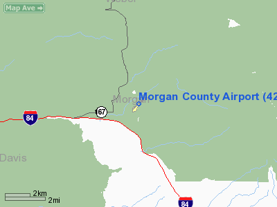
Location & QuickFacts
| FAA Information Effective: | 2008-09-25 |
| Airport Identifier: | 42U |
| Airport Status: | Operational |
| Longitude/Latitude: | 111-45-59.7720W/41-08-55.7940N
-111.766603/41.148832 (Estimated) |
| Elevation: | 5020 ft / 1530.10 m (Estimated) |
| Land: | 28 acres |
| From nearest city: | 8 nautical miles NW of Morgan, UT |
| Location: | Morgan County, UT |
| Magnetic Variation: | 15E (1985) |
Owner & Manager
| Ownership: | Publicly owned |
| Owner: | Morgan County |
| Address: | 48 West Young St., Po Box 886
Morgan, UT 84050 |
| Phone number: | 801-829-6811 |
| Manager: | Mr. David Gardiner |
| Address: | Po Box 886, 48 West Young Street
Morgan, UT 84050 |
| Phone number: | 801-829-6811 |
Airport Operations and Facilities
| Airport Use: | Open to public |
| Wind indicator: | Yes |
| Segmented Circle: | No |
| Control Tower: | No |
| Landing fee charge: | No |
| Sectional chart: | Salt Lake City |
| Region: | ANM - Northwest Mountain |
| Traffic Pattern Alt: | 980 ft |
| Boundary ARTCC: | ZLC - Salt Lake City |
| Tie-in FSS: | CDC - Cedar City |
| FSS on Airport: | No |
| FSS Toll Free: | 1-800-WX-BRIEF |
| NOTAMs Facility: | CDC (NOTAM-d service avaliable) |
Airport Communications
| CTAF: | 122.800 |
| Unicom: | 122.800 |
Airport Services
| Airframe Repair: | MINOR |
| Power Plant Repair: | MINOR |
| Bottled Oxygen: | HIGH |
| Bulk Oxygen: | NONE |
Runway Information
Runway 03/21
| Dimension: | 3904 x 50 ft / 1189.9 x 15.2 m |
| Surface: | ASPH, Fair Condition |
| |
Runway 03 |
Runway 21 |
| Longitude: | 111-46-20.3660W | 111-45-43.1060W |
| Latitude: | 41-08-42.0640N | 41-09-08.4000N |
| Traffic Pattern: | Left | Left |
| Markings: | Basic, Fair Condition | Basic, Fair Condition |
| Displaced threshold: | 212.00 ft | 214.00 ft |
| Obstruction: | 15 ft road, 209.0 ft from runway
APCH SLOPE 28:1 TO DSPLCD THR
+5 FT PERIMETER FENCE 120 FT FM RWY THLD. | 39 ft trees, 265.0 ft from runway, 100 ft left of centerline, 1:1 slope to clear
APCH SLOPE 13:1 TO DSPLCD THR.
+5 FT PERIMETER FENCE 45 FT FM RWY THLD. |
|
Radio Navigation Aids
| ID |
Type |
Name |
Ch |
Freq |
Var |
Dist |
| BMC | NDB | Brigham City | | 294.00 | 16E | 26.2 nm |
| TVY | NDB | Tooele | | 371.00 | 13E | 41.8 nm |
| HIF | TACAN | Hill | 049X | | 14E | 9.1 nm |
| EVW | VOR/DME | Evanston | 33X | 109.60 | 13E | 33.4 nm |
| LHO | VOR/DME | Brigham City | 076X | 112.90 | 14E | 40.2 nm |
| LGU | VOR/DME | Logan | 035X | 109.80 | 16E | 42.0 nm |
| OGD | VORTAC | Ogden | 104X | 115.70 | 14E | 15.7 nm |
| TCH | VORTAC | Wasatch | 115X | 116.80 | 16E | 20.4 nm |
| SLC | VOT | Salt Lake City | | 111.00 | | 33.4 nm |
Remarks
- PHONE AVAILABLE.
- DEP RY 21/ARR RY 03 REQ 1 MI STRAIGHT OUT/IN.
- HANGARS NORTH RY 03 THLD, 5 FT FENCE 120 FT NORTH RY 21 THLD & TREES NORTH RY 03/21 MIDFIELD.
- EXTENSIVE GLIDER AND ULTRALIGHT ACTIVITY ON AND INVOF ARPT.
- TREES, FENCES, AND HANGARS 125 FT FM CNTRLN BOTH SIDES RY 03/21.
- RY 3/21 BRAKING ACTION FAIR. RY MAY BE SLIPPERY WHEN WARM OR HOT.
- EXISTED PRIOR TO 1959.
Images and information placed above are from
http://www.airport-data.com/airport/42U/
We thank them for the data!
| General Info
|
| Country |
United States
|
| State |
UTAH
|
| FAA ID |
42U
|
| Latitude |
41-08-55.794N
|
| Longitude |
111-45-59.772W
|
| Elevation |
5020 feet
|
| Near City |
MORGAN
|
We don't guarantee the information is fresh and accurate. The data may
be wrong or outdated.
For more up-to-date information please refer to other sources.
|
|


