Michael Aaf (dugway Proving Ground) Airport in Utah Utah airports - Michael Aaf (dugway Proving Ground) Airport
Michael Aaf (dugway Proving Ground) Airport in Utah - United States
Utah Airports
USA Airports
World Airports
Airport photos
Aircraft photos
Spacecraft photos
Earth from airplane
Earth from space
Aviation Articles

Michael Aaf (dugway Proving Ground) Airport


Michael Army Airfield
USGS aerial image, 18 July 1998
IATA: DPG – ICAO: KDPG – FAA LID: DPG
Summary
Airport type Military: Army Airfield
Operator United States Army
Serves Dugway Proving Ground
Location Dugway, Utah
Built 1951
Elevation AMSL 4,349 ft / 1,326 m
Coordinates 40°11′58″N 112°56′15″W / 40.19944°N 112.9375°W / 40.19944; -112.9375
Runways
Direction Length Surface
ft m
12/30 11,000 3,353 Asphalt
Sources: Federal Aviation Administration

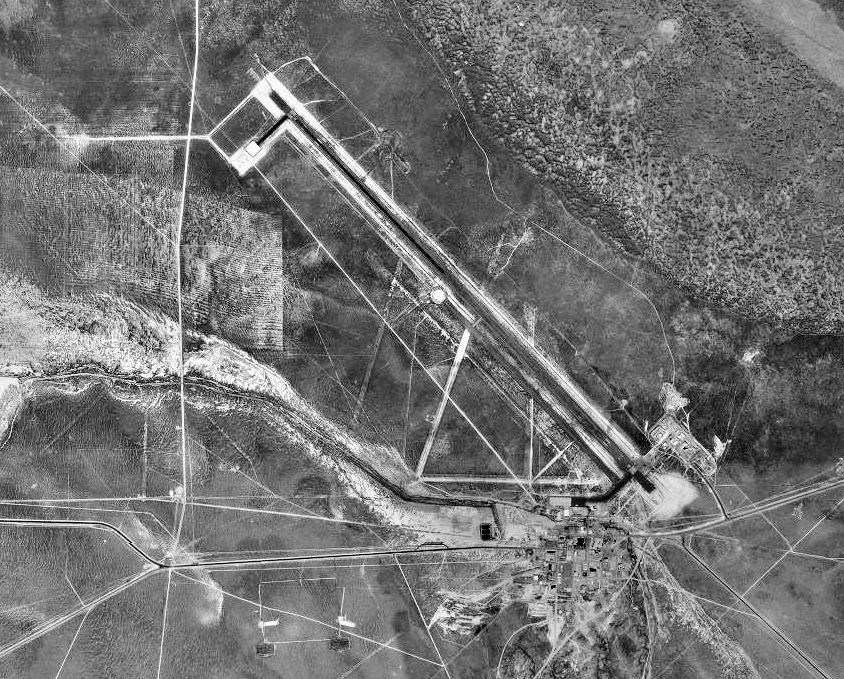
Michael Army Airfield (IATA: DPG, ICAO: KDPG, FAA LID: DPG) is a military airport located at the Dugway Proving Ground and owned by the United States Army. It is nine miles (14 km) west of the central business district of Dugway, Tooele County, Utah, United States.

Overview

Michael Army Airfield (MAAF) is located in a secluded, distant location and the secretive nature of its missions are generally undisclosed by the Army. Built by the Army during World War II, as Dugway Army Airfield, the facility is located in the Dugway Proving Ground which is one of the Army's main facilities for developing defenses against biological and chemical attacks. Workers at Dugway test defense gear to make sure they can survive nuclear, biological and chemical attacks.

MAAF is located just south of Hill Air Force Base's massive Utah Test and Training Range, where F-16 Falcon fighters from Hill train in air-to-air combat and the Air Force tests cruise missiles, and is used occasionally by the Air Force as an emergency landing field.

It has been called the "new Area 51" by some, with the Dugway Proving Ground serving as a buffer zone, as the Nevada Test Site served for Groom Lake.

Projects

In the 1990s, MAAF was associated with the NASA X-38 Crew Return Vehicle (CRV) program, for the International Space Station. That program, however, was canceled in 2002 due to budget cuts.

One frequently rumored test project is the Lockheed Martin X-33. It is undetermined if MAAF will be used in association with the Boeing X-37 Advanced Technology Demonstrator, the military derivative of the X-38, a classified project which was transferred from NASA to the Defense Advanced Research Projects Agency on 13 September 2004.

In 2009, it was announced that Michael AAF will be used for the development and testing of Unmanned Aircraft Systems (UAS), which are sent overseas to provide soldiers with an aerial view - via video feed - of combat situations.

Facilities

Michael AAF previously had a 13,125 foot runway which was in poor condition. An FAA airport diagram effective January 2008 shows a 7,000 by 150 foot runway (12/30) open parallel to the prior runway, but the diagram effective February 2009 shows a new 11,000 by 150 foot runway is open in place of the original runway.


The above content comes from Wikipedia and is published under free licenses – click here to read more.

Michael Aaf (dugway Proving Ground) Airport picture


Location & QuickFacts

FAA Information Effective:2008-09-25
Airport Identifier:DPG
Airport Status:Operational
Longitude/Latitude:112-56-14.8900W/40-11-57.7900N
-112.937469/40.199386 (Estimated)
Elevation:4349 ft / 1325.58 m (Estimated)
Land:0 acres
From nearest city:9 nautical miles W of Dugway Proving Ground, UT
Location:Tooele County, UT
Magnetic Variation:15E (1985)

Owner & Manager

Ownership:Army owned
Owner:Us Army Atca-aso
Address:Cameron Station
Alexandria, VA 22314
Phone number:435-831-5322
BASE-OPS@ DPG.
Manager:Base Operation
Address:Michael Aaf (dugway Proving Ground)
Ut
Phone number:435-831-5322

Airport Operations and Facilities

Airport Use:Private
Segmented Circle:No
Control Tower:No
Lighting Schedule:DUSK-DAWN
ACTVT HIRL RY 12/30 & TWY LGTS - CTAF.
Beacon Color:Split-Clear-Green (lighted military airport)
Sectional chart:Salt Lake City
Region:ANM - Northwest Mountain
Boundary ARTCC:ZLC - Salt Lake City
Tie-in FSS:CDC - Cedar City
FSS-CEDAR CITY CDC-NOTAM CDC.
FSS on Airport:No
FSS Toll Free:1-800-WX-BRIEF
NOTAMs Facility:CDC (NOTAM-d service avaliable)

Airport Communications

CTAF:126.200

Runway Information

Runway 12/30

Dimension:11000 x 150 ft / 3352.8 x 45.7 m
Surface:ASPH,
PEM.
Surface Treatment:Saw-cut or plastic Grooved
Pavement Class:73 /R/B/W/T
Edge Lights:High
NW FIRST 5000 FT HIRL OTS INDEFLY.
 

Runway 12

Runway 30

Traffic Pattern:LeftLeft
Arresting:E5
Displaced threshold:1000.00 ft1000.00 ft
Approach lights:SALS

Radio Navigation Aids

ID Type Name Ch Freq Var Dist
DPGNDBDugway284.0015E1.0 nm
TVYNDBTooele371.0013E36.6 nm
MIJTACANMichael079X 15E0.8 nm
FFUVORTACFairfield113X116.6016E46.0 nm
BVLVORTACBonneville070X112.3017E49.1 nm

Remarks

  • RSTD: 24 HR PPR FOR LDG AND FUEL; CTC BASE OPS DSN 789-5322, C 435-831-5322.ALL USAF, ANG, AND AFRES AMC ACFT CONSULT ASRR FOR THIS LCTN.
  • RWY 12R-30L CLSD.
  • CAUTION: POTENTIAL FOR WILD ANIMALS TO CROSS RWY AND FOREIGN OBJECT DAMAGE HAZ DURING HIGH WIND CONDITIONS. BIRD ACT MNT O/R.
  • A-GEAR: RY 12 HOOK E5 9035.
  • C130 AND LARGER ACFT PROHIBITED FROM MAKING 180 DEG TURNS ON ASPHALT, USE CONCRETE TURNAROUNDS ON OVRN.
  • SERVICE LGT: ACTIVATE-HIRL RWY 12-30, TWY LGT AND SALS RWY 12-126.2.
  • JASU: 2 (A/M32A-86) 2(A/M32A-60).
  • FUEL: J8. IDENTAPLATE RQR.
  • OIL: O-156.
  • TRAN ALERT: OPR 1400-0030Z++ MON-THU EXC HOL.
  • SEE FLIP AP/1 SUPPLEMENTARY ARPT RMK.

Images and information placed above are from
http://www.airport-data.com/airport/DPG/

We thank them for the data!


General Info
Country United States
State UTAH
FAA ID DPG
Latitude 40-11-57.787N
Longitude 112-56-14.897W
Elevation 4349 feet
Near City DUGWAY PROVING GROUND


We don't guarantee the information is fresh and accurate. The data may be wrong or outdated.
For more up-to-date information please refer to other sources.


christianity portal
directory of hotels worldwide


Copyright 2004-2024 © by Airports-Worldwide.com, Vyshenskoho st. 36, Lviv 79010, Ukraine
Legal Disclaimer