|
 |
|
||||
|
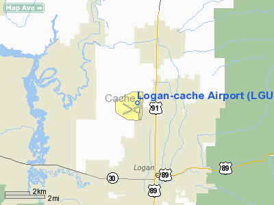
Logan-Cache Airport (IATA: LGU, ICAO: KLGU) is a public airport located three miles (5 km) northwest of the city of Logan in Cache County, Utah, USA. The Logan-Cache Airport is currently a General Aviation Airport and is governed by the Logan-Cache Airport Authority formed by Inter-local Agreement between Cache County and Logan City in 1992. The Airport was previously owned by Cache County and managed by the County Commissioners. The Authority is governed by a seven member board: The Mayor of Logan, the Cache County Executive, two members appointed by the Mayor, two members appointed by the County Executive and the seventh member appointed by the other board members. The mayor and executive serve during their terms in elected office and the other five members serve for a period of two years and may be reappointed. The authority is subsidized by Logan City and Cache County and has no power to tax or bond for additional funding. Its revenues are derived from leases of land, buildings, fuel flow fees and tie down fees. Logan Cache Airport has two fixed wing training schools located on the field, one sponsored by Utah State University, and the other is Privately owned by Leading Edge Aviation, (Not to mention several independent CFI's.) New to the airport, a rotorcraft school, Mountain Ridge Helicopters, has opened up shop. Logan is also home to several active glider pilots who love flying the thermals up against the mountains. Commercial Airline ServiceThere is no current commercial service into Logan-Cache Airport, however, Frontier Airlines (operated by Lynx Aviation) were looking into starting flights to their hub at Denver International Airport using the Bombardier Q400 aircraft. It is now up to the community to raise one million dollars in start-up to subsidize the service. Since the proposal, Frontier Airlines has announced the discontinuation of Lynx Aviation services (a subsidiary of Frontier Airlines) by fall of 2010. With the loss of the Q400, service, if started, may be turned over to regional jets operated by Frontier codeshare partners. Horizon Air, a wholly owned subsidiary of Alaska Air Group, has recently voiced interest in serving the smaller communities of Utah, including Logan-Cache airport, and Provo Regional Airport, both would be serviced with the Q400 turboprop. Utah air carrier Transwestern Airlines operated company headquarters out of Logan airport, with service to their hub at Salt Lake International until their acquisition by Horizon Air in December of 1983. Airport UsageLogan-Cache airport is the training base for all Utah State University aviation students. Utah State University currently occupies the "Utah Jet Center" hangar on the North end of the airport access road. The university also operates the dispatch office located in the main passenger terminal, adjacent to Utah Jet Center. Leading Edge Aviation Utah is located near the public parking lot, on the East side of the main airport access road. Leading Edge is both a flight training center, as well as an FBO, and a well-stocked pilot shop. Leading Edge also operates a Self-Serv 100LL pump just South of its building location. Mountain Ridge Helicopters is located on the West end of the passenger access road, and features solely rotor-wing flight training. In addition to their fleet of Robinson and McDonnell Douglas Helicopters, Mountain Ridge also operates a FTD Flight Training Device for its students. Utah Jet Center is the leading FBO on the airfield for Jet aircraft operations. Several large corporations based out of Logan, such as RR Donnelly, and Gossner foods, means Logan sees several large business jets during the work week. Utah Jet Center is ready to help with fuel, parking, reservations, and a courtesy car based on the field. New Air Helicopters of Durango, Colorado has moved a part of it's fleet to the Logan- Cache airport. New Air operates a fleet of Bell 206 helicopters and is the only FAA Approved Charter company on the field. New Air also holds Part 133 and 137 certificates. New Air provides exclusive helicopter charter services, long- line/ external load operations, aerial survey/ photography as well as search and rescue. FacilitiesLogan-Cache Airport covers 602 acres (244 ha) and has two runways:
TriviaRunway 35-17 is the second longest public runway in Utah, second only to Salt Lake International; it's a pretty new runway and very smooth. On the other hand, runway 28-10 is a little worn out and they're lobbying hard to have it resurfaced. When landing runway 28-10, remember to practice your soft field landing techniques and keep light on that front wheel as it bounces over the rough stuff. Logan-Cache airport has 2 standing air traffic control towers for field use. Regardless, Logan has not seen air traffic control service for many years, and remains a Class E, uncontrolled airport. The North tower is owned by Utah Jet Center, and is used primarily for advertising its logo incoming aircraft. The though has been to convert this tower into a lounge, for flight instructors to observe their students as they solo flight in the pattern. Due to the age of the tower, safety concerns have ruled this option out. The second, larger tower at the south end of the field is privately owned, and is used as a jumping training tower. The above content comes from Wikipedia and is published under free licenses – click here to read more.
Location & QuickFacts
Owner & Manager
Airport Operations and Facilities
Airport Communications
Airport Services
Runway InformationRunway 10/28
Runway 17/35
Radio Navigation Aids
Images and information placed above are from We thank them for the data!
We don't guarantee the information is fresh and accurate. The data may
be wrong or outdated.
|
|||||||||||||||||||||||||||||||||||||||||||||||||||||||||||||||||||||||||||||||||||||||||||||||||||||||||||||||||||||||||||||||||||||||||||||||||||||||||||||||||||||||||||||||||||||||||||||||||||||||||||||||||||||||||||||||||||||||||||||||||||||||||||||||||||||||||||||||||||||||||||||||||||||||||||||||||||||||||||||||||||

 |
|
Copyright 2004-2026 © by Airports-Worldwide.com, Vyshenskoho st. 36, Lviv 79010, Ukraine Legal Disclaimer |