 |
|
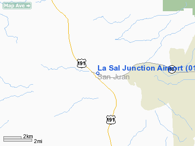
Location & QuickFacts
| FAA Information Effective: | 2008-09-25 |
| Airport Identifier: | 01UT |
| Airport Status: | Operational |
| Longitude/Latitude: | 109-23-47.4080W/38-18-29.9500N
-109.396502/38.308319 (Estimated) |
| Elevation: | 6000 ft / 1828.80 m (Estimated) |
| Land: | 0 acres |
| From nearest city: | 6 nautical miles W of La Sal, UT |
| Location: | San Juan County, UT |
| Magnetic Variation: | 13E (1985) |
Owner & Manager
| Ownership: | Privately owned |
| Owner: | K Mc Dougald |
| Address: | Box 1330, Mc Dougald Oil Co
Moab, UT 84532 |
| Phone number: | 801-259-6156 |
| Manager: | K Mc Dougald |
| Address: | Box 1330, Mc Dougald Oil Co
Moab, UT 84532 |
| Phone number: | 801-259-6156 |
Airport Operations and Facilities
| Airport Use: | Private |
| Wind indicator: | Yes |
| Segmented Circle: | No |
| Control Tower: | No |
| Landing fee charge: | No |
| Sectional chart: | Denver |
| Region: | ANM - Northwest Mountain |
| Boundary ARTCC: | ZDV - Denver |
| Tie-in FSS: | CDC - Cedar City |
| FSS on Airport: | No |
| FSS Toll Free: | 1-800-WX-BRIEF |
Airport Services
| Airframe Repair: | NONE |
| Power Plant Repair: | NONE |
Runway Information
Runway E/W
| Dimension: | 3200 x 40 ft / 975.4 x 12.2 m |
| Surface: | DIRT, Poor Condition |
| |
Runway E |
Runway W |
| Traffic Pattern: | Left | Left |
| Markings: | None, | None, |
| Runway End Identifier: | No | No |
| Centerline Lights: | No | No |
| Touchdown Lights: | No | No |
| Obstruction: | 30 ft hill, 400.0 ft from runway, 100 ft left of centerline, 13:1 slope to clear | 18 ft tree, 100.0 ft from runway, 30 ft right of centerline, 5:1 slope to clear |
|
Radio Navigation Aids
| ID |
Type |
Name |
Ch |
Freq |
Var |
Dist |
| HPL | NDB | Hopkins | | 375.00 | 13E | 39.4 nm |
| OAB | VOR/DME | Moab | 035X | 109.80 | 15E | 31.6 nm |
| DVC | VORTAC | Dove Creek | 093X | 114.60 | 14E | 37.2 nm |
Remarks
- LAND EAST TAKEOFF TO WEST DUE TO GRADIENT.
- LANDING SURFACE ROUGH, SOFT WHEN WET.
- EAST RWY HAS 6 TO 8 INCHES DITCH ON BOTH SIDES FROM DRAINAGE.
- EAST RWY HAS 6 INCHES - 8 INCHES DITCH ON BOTH SIDES FROM DRAINAGE.
- ESTABD PRIOR TO 1959.
Images and information placed above are from
http://www.airport-data.com/airport/01UT/
We thank them for the data!
| General Info
|
| Country |
United States
|
| State |
UTAH
|
| FAA ID |
01UT
|
| Latitude |
38-18-29.950N
|
| Longitude |
109-23-47.408W
|
| Elevation |
6000 feet
|
| Near City |
LA SAL
|
We don't guarantee the information is fresh and accurate. The data may
be wrong or outdated.
For more up-to-date information please refer to other sources.
|
|


