 |
|
Heber City Muni - Russ Mcdonald Field Airport |
Coordinates: 40°28.916′N 111°25.602′W / 40.481933°N 111.4267°W / 40.481933; -111.4267
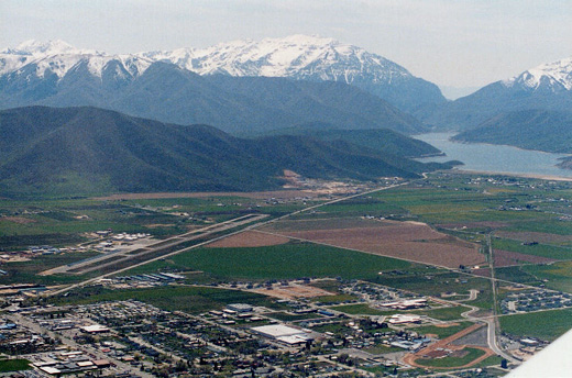 | |
Heber valley, with the airport visible in the left portion of the valley |
Heber City Municipal Airport (ICAO: K36U, LOC ID: 36U) is a single runway (runways 3/21), untowered airport in Heber, Utah, east of Salt Lake City, Utah. The airport was activated in November 1947. It is owned by Heber city. It is primarily (83% in 2008) used by single engine aircraft for local, general aviation.
The above content comes from Wikipedia and is published under free licenses – click here to read more.
Location & QuickFacts
| FAA Information Effective: | 2008-09-25 |
| Airport Identifier: | 36U |
| Airport Status: | Operational |
| Longitude/Latitude: | 111-25-43.7000W/40-28-54.5000N
-111.428806/40.481806 (Estimated) |
| Elevation: | 5637 ft / 1718.16 m (Surveyed) |
| Land: | 401 acres |
| From nearest city: | 1 nautical miles S of Heber, UT |
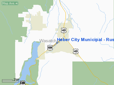
| Location: | Wasatch County, UT |
| Magnetic Variation: | 14E (2000) |
Owner & Manager
| Ownership: | Publicly owned |
| Owner: | Heber City |
| Address: | 75 N. Main Street
Heber, UT 84032 |
| Manager: | Lee Ivie |
| Address: | 75 North Main Street
Heber, UT 84032 |
| Phone number: | 801-420-2852 |
Airport Operations and Facilities
| Airport Use: | Open to public |
| Wind indicator: | Yes |
| Segmented Circle: | Yes |
| Control Tower: | No |
| Lighting Schedule: | DUSK-DAWN
ACTVT MIRL RWY 03/21 & PAPI RY 21 - CTAF. |
| Beacon Color: | Clear-Green (lighted land airport) |
| Landing fee charge: | No |
| Sectional chart: | Salt Lake City |
| Region: | ANM - Northwest Mountain |
| Boundary ARTCC: | ZLC - Salt Lake City |
| Tie-in FSS: | CDC - Cedar City |
| FSS on Airport: | No |
| FSS Toll Free: | 1-800-WX-BRIEF |
| NOTAMs Facility: | CDC (NOTAM-d service avaliable) |
| Federal Agreements: | NGY |
Airport Communications
| CTAF: | 122.800 |
| Unicom: | 122.800 |
Airport Services
| Fuel available: | 100LLA
SELF SERVE 100LL WITH CREDIT CARD |
| Airframe Repair: | MAJOR |
| Power Plant Repair: | MAJOR |
| Bottled Oxygen: | NONE |
| Bulk Oxygen: | HIGH/LOW |
Runway Information
Runway 03/21
| Dimension: | 6899 x 75 ft / 2102.8 x 22.9 m |
| Surface: | ASPH, Good Condition |
| Weight Limit: | Single wheel: 12000 lbs. |
| Edge Lights: | Medium |
| |
Runway 03 |
Runway 21 |
| Longitude: | 111-26-17.7610W | 111-25-09.6200W |
| Latitude: | 40-28-32.4814N | 40-29-16.4923N |
| Elevation: | 5583.00 ft | 5637.00 ft |
| Alignment: | 50 | 127 |
| Traffic Pattern: | Left | Left |
| Markings: | Basic, Fair Condition | Basic, Fair Condition |
| Crossing Height: | 0.00 ft | 45.00 ft |
| VASI: | | 4-light PAPI on left side
RWY 21 PAPI UNUSBL BYD 3.5 NM FM RY THLD & 6 DEGS FM RY CNTRLN. |
| Visual Glide Angle: | 0.00° | 4.00° |
| Obstruction: | 23 ft road, 915.0 ft from runway, 269 ft left of centerline, 31:1 slope to clear | 31 ft pole, 1185.0 ft from runway, 188 ft left of centerline, 32:1 slope to clear |
|
Radio Navigation Aids
| ID |
Type |
Name |
Ch |
Freq |
Var |
Dist |
| TVY | NDB | Tooele | | 371.00 | 13E | 42.7 nm |
| HIF | TACAN | Hill | 049X | | 14E | 45.5 nm |
| PVU | VOR/DME | Provo | 021X | 108.40 | 15E | 20.9 nm |
| FFU | VORTAC | Fairfield | 113X | 116.60 | 16E | 26.5 nm |
| TCH | VORTAC | Wasatch | 115X | 116.80 | 16E | 33.6 nm |
| SLC | VOT | Salt Lake City | | 111.00 | | 27.1 nm |
Remarks
- ACFT DEPARTING SOUTH-SOUTHWESTBOUND BE AWARE OF HIGH TFC VOLUME DESCENDING TO 16,000 FT OVER SPANE INTERSECTION.
- EXISTED PRIOR TO 1959.
Images and information placed above are from
http://www.airport-data.com/airport/36U/
We thank them for the data!
| General Info
|
| Country |
United States
|
| State |
UTAH
|
| FAA ID |
36U
|
| Latitude |
40-28-54.500N
|
| Longitude |
111-25-43.700W
|
| Elevation |
5637 feet
|
| Near City |
HEBER
|
We don't guarantee the information is fresh and accurate. The data may
be wrong or outdated.
For more up-to-date information please refer to other sources.
|
|


