 |
|
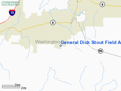
General Dick Stout Field Airport |
Location & QuickFacts
| FAA Information Effective: | 2008-09-25 |
| Airport Identifier: | 1L8 |
| Airport Status: | Operational |
| Longitude/Latitude: | 113-18-22.8170W/37-08-19.9380N
-113.306338/37.138872 (Estimated) |
| Elevation: | 3347 ft / 1020.17 m (Estimated) |
| Land: | 170 acres |
| From nearest city: | 3 nautical miles S of Hurricane, UT |
| Location: | Washington County, UT |
| Magnetic Variation: | 14E (1985) |
Owner & Manager
| Ownership: | Publicly owned |
| Owner: | City Of Hurricane |
| Address: | 147 North 870 West
Hurricane, UT 84737 |
| Phone number: | 435-635-2811 |
| Manager: | Charles R. Reeve |
| Address: | 331 N. 2260 W.
Hurricane, UT 84737 |
| Phone number: | 435-635-4350 |
Airport Operations and Facilities
| Airport Use: | Open to public |
| Wind indicator: | Yes |
| Segmented Circle: | Yes |
| Control Tower: | No |
| Landing fee charge: | No |
| Sectional chart: | Las Vegas |
| Region: | ANM - Northwest Mountain |
| Boundary ARTCC: | ZLA - Los Angeles |
| Tie-in FSS: | CDC - Cedar City |
| FSS on Airport: | No |
| FSS Toll Free: | 1-800-WX-BRIEF |
| NOTAMs Facility: | CDC (NOTAM-d service avaliable) |
| Federal Agreements: | 1 |
Airport Communications
| CTAF: | 122.800 |
| Unicom: | 122.800 |
Airport Services
| Fuel available: | 100LLA
FUEL AVAILABLE 24 HOURS, SELF-SERVE CREDIT CARD FUELING SYSTEM |
| Airframe Repair: | MAJOR |
| Power Plant Repair: | MAJOR |
| Bottled Oxygen: | NONE |
| Bulk Oxygen: | NONE |
Runway Information
Runway 18/36
| Dimension: | 3410 x 40 ft / 1039.4 x 12.2 m |
| Surface: | ASPH, Poor Condition
RY 18/36 UNDULATING SFC. |
| Weight Limit: | Single wheel: 3000 lbs. |
| |
Runway 18 |
Runway 36 |
| Traffic Pattern: | Right | Left |
| Markings: | Basic, Good Condition | Basic, Good Condition |
| Obstruction: | , 50:1 slope to clear
RWY 18 +13' ROAD 165' FROM THR. | 5 ft fence, 206.0 ft from runway, 1:1 slope to clear |
|
Radio Navigation Aids
| ID |
Type |
Name |
Ch |
Freq |
Var |
Dist |
| AZC | NDB | Colorado City | | 403.00 | 13E | 17.9 nm |
| OZN | VOR/DME | St George | 035X | 109.80 | 15E | 14.0 nm |
| CDC | VOR/DME | Cedar City | 120X | 117.30 | 16E | 40.6 nm |
Remarks
- RWY 18/36 PILOTS AT END OF RWY CANNOT SEE ACFT AT OTHER END.
Images and information placed above are from
http://www.airport-data.com/airport/1L8/
We thank them for the data!
| General Info
|
| Country |
United States
|
| State |
UTAH
|
| FAA ID |
1L8
|
| Latitude |
37-08-19.938N
|
| Longitude |
113-18-22.817W
|
| Elevation |
3347 feet
|
| Near City |
HURRICANE
|
We don't guarantee the information is fresh and accurate. The data may
be wrong or outdated.
For more up-to-date information please refer to other sources.
|
|


