 |
|
| Fillmore Municipal Airport |
| IATA: FIL – ICAO: KFOM – FAA LID: FOM |
| Summary |
| Airport type |
Public |
| Owner |
City of Fillmore |
| Serves |
Fillmore, Utah |
| Elevation AMSL |
4,985 ft / 1,519 m |
| Coordinates |
38°57′29″N 112°21′47″W / 38.95806°N 112.36306°W / 38.95806; -112.36306 |
| Runways |
| Direction |
Length |
Surface |
| ft |
m |
| 4/22 |
5,040 |
1,536 |
Asphalt |
| Statistics (2006) |
| Aircraft operations |
1,787 |
| Source: Federal Aviation Administration |
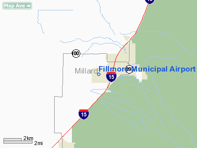
Fillmore Municipal Airport (IATA: FIL, ICAO: KFOM, FAA LID: FOM) is a city-owned public-use airport located two nautical miles (4 km) west of the central business district of Fillmore, a city in Millard County, Utah, United States.
Although most U.S. airports use the same three-letter location identifier for the FAA and IATA, this airport is assigned FOM by the FAA and FIL by IATA (which assigned FOM to Foumban Airport in Foumban, Cameroon).
Facilities and aircraft
Fillmore Municipal Airport covers an area of 241 acres (98 ha) at an elevation of 4,985 feet (1,519 m) above mean sea level. It has one asphalt paved runway designated 4/22 which measures 5,040 by 75 feet (1,536 x 23 m). For the 12-month period ending December 31, 2006, the airport had 1,787 aircraft operations, an average of 148 per month: 98% general aviation and 2% air taxi.
The above content comes from Wikipedia and is published under free licenses – click here to read more.
Location & QuickFacts
| FAA Information Effective: | 2008-09-25 |
| Airport Identifier: | FOM |
| Airport Status: | Operational |
| Longitude/Latitude: | 112-21-47.7780W/38-57-29.8690N
-112.363272/38.958297 (Estimated) |
| Elevation: | 4988 ft / 1520.34 m (Estimated) |
| Land: | 241 acres |
| From nearest city: | 2 nautical miles W of Fillmore, UT |
| Location: | Millard County, UT |
| Magnetic Variation: | 14E (1985) |
Owner & Manager
| Ownership: | Publicly owned |
| Owner: | City Of Fillmore |
| Address: | 75 West Center
Fillmore, UT 84631-0687 |
| Phone number: | 435-743-5233 |
| Manager: | Yvonne Hancock |
| Address: | 1120 West 200 South
Fillmore, UT 84631 |
| Phone number: | 435-743-6150 |
Airport Operations and Facilities
| Airport Use: | Open to public |
| Wind indicator: | Yes |
| Segmented Circle: | Yes |
| Control Tower: | No |
| Lighting Schedule: | DUSK-DAWN
ACTVT MIRL RY 04/22, PAPI RYS 04 AND RY 22 - CTAF. |
| Beacon Color: | Clear-Green (lighted land airport) |
| Landing fee charge: | No |
| Sectional chart: | Las Vegas |
| Region: | ANM - Northwest Mountain |
| Boundary ARTCC: | ZLC - Salt Lake City |
| Tie-in FSS: | CDC - Cedar City |
| FSS on Airport: | No |
| FSS Toll Free: | 1-800-WX-BRIEF |
| NOTAMs Facility: | CDC (NOTAM-d service avaliable) |
Airport Communications
| CTAF: | 122.800 |
| Unicom: | 122.800 |
Airport Services
| Airframe Repair: | NONE |
| Power Plant Repair: | NONE |
| Bottled Oxygen: | NONE |
| Bulk Oxygen: | NONE |
Runway Information
Runway 04/22
| Dimension: | 5040 x 75 ft / 1536.2 x 22.9 m |
| Surface: | ASPH, Good Condition |
| Weight Limit: | Single wheel: 12500 lbs. |
| Edge Lights: | Medium |
| |
Runway 04 |
Runway 22 |
| Traffic Pattern: | Left | Left |
| Markings: | Non-precision instrument, Good Condition | Non-precision instrument, Good Condition |
| VASI: | 2-light PAPI on left side | 2-light PAPI on left side |
| Runway End Identifier: | No | No |
| Obstruction: | , 50:1 slope to clear | 28 ft road, 660.0 ft from runway, 270 ft right of centerline, 16:1 slope to clear |
|
Radio Navigation Aids
| ID |
Type |
Name |
Ch |
Freq |
Var |
Dist |
| DTA | VORTAC | Delta | 108X | 116.10 | 16E | 21.7 nm |
| MLF | VORTAC | Milford | 058X | 112.10 | 16E | 47.1 nm |
Remarks
Images and information placed above are from
http://www.airport-data.com/airport/FOM/
We thank them for the data!
| General Info
|
| Country |
United States
|
| State |
UTAH
|
| FAA ID |
FOM
|
| Time |
UTC-7(-6DT)
|
| Latitude |
38.958298
38° 57' 29.87" N
|
| Longitude |
-112.363272
112° 21' 47.78" W
|
| Elevation |
4988 feet
1520 meters
|
| Magnetic Variation |
012° E (07/06)
|
| Beacon |
Yes
|
| Operating Agency |
MUNICIPAL
|
| Operating Hours |
24 HOUR OPERATIONS
|
| Daylight Saving Time |
Second Sunday in March at 0200 to first Sunday in November at 0200 local time (Exception Arizona and that portion of Indiana in the Eastern Time Zone)
|
We don't guarantee the information is fresh and accurate. The data may
be wrong or outdated.
For more up-to-date information please refer to other sources.
|
|


