 |
|
| Cedar City Regional Airport |
 |
| IATA: CDC – ICAO: KCDC – FAA LID: CDC |
| Summary |
| Airport type |
public |
| Owner/Operator |
Cedar City Corporation |
| Location |
Cedar City, Utah |
| Elevation AMSL |
5622 ft / 1713.6 m |
| Coordinates |
37°42′03″N 113°05′56″W / 37.70083°N 113.09889°W / 37.70083; -113.09889Coordinates: 37°42′03″N 113°05′56″W / 37.70083°N 113.09889°W / 37.70083; -113.09889 |
| Website |
CedarCity.org |
| Runways |
| Direction |
Length |
Surface |
| ft |
m |
| 220 |
8653 |
|
Asphalt |
| 8/26 |
4822 |
|
Grooved Asphalt |
| Statistics (2008) |
| Aircraft operations |
30,065 |
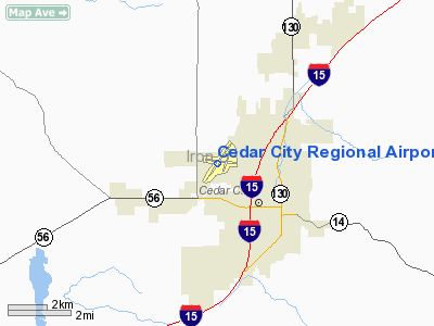
Cedar City Regional Airport (IATA: CDC, ICAO: KCDC, FAA LID: CDC) is a public airport located two miles (3 km) northwest of the central business district (CBD) of Cedar City, in Iron County, Utah, United States. The airport covers 1,040 acres (421 ha) and has two runways. It is mostly used for general aviation, but is also used for commercial airline flights. Essential Air Service is a government-funded program that subsidizes non-stop service between Salt Lake City and Cedar City.
History
SkyWest Airlines provided Essential Air Service (EAS) from 1972 until 2005 when Air Midwest, a subsidiary of Mesa Airlines was awarded the contract. Mayor Gerald Sherratt was quoted as saying “This is not good” when told the news about Mesa being awarded the contract. Citizens wrote to senator Orrin Hatch which prompted him in 2007 to write a letter to the United States Department of Transportation to urge them to select a new carrier to provide air service to Cedar City. Late in 2007, Mesa filed to discontinue service to Cedar City, and a new contract was awarded to SkyWest.
Airlines and destinations
| Airlines |
Destinations |
| Delta Connection operated by SkyWest Airlines |
Salt Lake City |
The above content comes from Wikipedia and is published under free licenses – click here to read more.
Location & QuickFacts
| FAA Information Effective: | 2008-09-25 |
| Airport Identifier: | CDC |
| Airport Status: | Operational |
| Longitude/Latitude: | 113-05-55.8450W/37-42-03.4790N
-113.098846/37.700966 (Estimated) |
| Elevation: | 5622 ft / 1713.59 m (Surveyed) |
| Land: | 1040 acres |
| From nearest city: | 2 nautical miles NW of Cedar City, UT |
| Location: | Iron County, UT |
| Magnetic Variation: | 14E (1990) |
Owner & Manager
| Ownership: | Publicly owned |
| Owner: | Cedar City Corporation |
| Address: | 10 North Main
Cedar City, UT 84720 |
| Phone number: | 435-586-2950 |
| Manager: | Steve Farmer |
| Address: | 2560 Aviation Way
Cedar City, UT 84720 |
| Phone number: | 435-867-9408 |
Airport Operations and Facilities
| Airport Use: | Open to public |
| Wind indicator: | Yes |
| Segmented Circle: | Yes |
| Control Tower: | No |
| Lighting Schedule: | DUSK-DAWN
ACTVT MIRL RYS 02/20 & 08/26, MALSR RY 20, REIL RYS 02, 08 & 26 AND PAPI RYS 02, 20 & 08 - CTAF. |
| Beacon Color: | Clear-Green (lighted land airport) |
| Landing fee charge: | No |
| Sectional chart: | Las Vegas |
| Region: | ANM - Northwest Mountain |
| Traffic Pattern Alt: | 777 ft |
| Boundary ARTCC: | ZLC - Salt Lake City |
| Tie-in FSS: | CDC - Cedar City
CTC CEDAR CITY FLT SVCS FOR AIRPORT ADVISORY SERVICE ON 123.6. |
| FSS on Airport: | No |
| FSS Toll Free: | 1-800-WX-BRIEF |
| NOTAMs Facility: | CDC (NOTAM-d service avaliable) |
| Certification type/date: | II A S 12/200
CLSD TO UNSKED ACR OPNS WITH MORE THAN 30 PSGR SEATS EXCP 24 HR PPR CALL AMGR 435-586-2964. |
| Federal Agreements: | NGSY3 |
Airport Communications
| CTAF: | 123.000 |
| Unicom: | 123.000 |
Airport Services
| Fuel available: | 100LLA
100LL FUEL AVBL 24 HRS SELF-SVC CREDIT CARD SYSTEM. |
| Airframe Repair: | MAJOR |
| Power Plant Repair: | MAJOR |
| Bottled Oxygen: | HIGH/LOW |
Runway Information
Runway 02/20
| Dimension: | 8653 x 150 ft / 2637.4 x 45.7 m |
| Surface: | ASPH, Fair Condition |
| Surface Treatment: | Porous Friction Course |
| Weight Limit: | Single wheel: 75000 lbs.
Dual wheel: 100000 lbs.
Dual tandem wheel: 150000 lbs. |
| Edge Lights: | Medium |
| |
Runway 02 |
Runway 20 |
| Longitude: | 113-06-28.1340W | 113-05-27.5470W |
| Latitude: | 37-41-26.1850N | 37-42-36.8660N |
| Elevation: | 5578.00 ft | 5600.00 ft |
| Alignment: | 34 | 127 |
| ILS Type: | | ILS
|
| Traffic Pattern: | Left | Right |
| Markings: | Non-precision instrument, Fair Condition | Precision instrument, Fair Condition |
| Crossing Height: | 56.00 ft | 53.00 ft |
| VASI: | 4-light PAPI on left side | 4-light PAPI on left side |
| Visual Glide Angle: | 3.00° | 3.00° |
| Approach lights: | | MALSR |
| Runway End Identifier: | Yes
REIL RY 02 OTS INDEFLY. | |
|
Runway 08/26
| Dimension: | 4822 x 60 ft / 1469.7 x 18.3 m |
| Surface: | ASPH, Good Condition |
| Weight Limit: | Single wheel: 16500 lbs. |
| Edge Lights: | Medium |
| |
Runway 08 |
Runway 26 |
| Longitude: | 113-06-22.0540W | 113-05-22.4770W |
| Latitude: | 37-42-09.8080N | 37-42-04.1560N |
| Elevation: | 5579.00 ft | 5622.00 ft |
| Alignment: | 97 | 127 |
| Traffic Pattern: | Left | Right |
| Markings: | Basic, Good Condition | Basic, Good Condition |
| Crossing Height: | 40.00 ft | 0.00 ft |
| VASI: | 4-light PAPI on left side | |
| Visual Glide Angle: | 3.00° | 0.00° |
| Runway End Identifier: | Yes | Yes |
| Obstruction: | 40 ft pole, 1800.0 ft from runway, 40:1 slope to clear
+40' POLES ON RWY CNTRLN EXTDD. | 18 ft road, 661.0 ft from runway, 26:1 slope to clear |
|
Radio Navigation Aids
| ID |
Type |
Name |
Ch |
Freq |
Var |
Dist |
| AZC | NDB | Colorado City | | 403.00 | 13E | 44.8 nm |
| CDC | VOR/DME | Cedar City | 120X | 117.30 | 16E | 5.4 nm |
| OZN | VOR/DME | St George | 035X | 109.80 | 15E | 43.7 nm |
| BCE | VORTAC | Bryce Canyon | 075X | 112.80 | 15E | 37.8 nm |
| MLF | VORTAC | Milford | 058X | 112.10 | 16E | 39.8 nm |
Remarks
- GA ACFT NOT PERMITTED ON ACR RAMP.
- RCMD PILOTS CIRCLE ARPT FOR ALT BEFORE DEPARTING EBND DUE TO FAST RISING TRRN & HI DNSTY ALT. TURBC LIKELY IN VCNTY OF MNTS & PASSES.
- RY 08/26 & TWY B NOT AVBL FOR ACR ACFT WITH OVER 30 PASSENGER SEATS.
- DUE TO CROWN IN RY 02/20 DEPARTING ACFT ARE UNABLE TO OBSERVE ACFT DEPARTING IN OPPOSITE DIRECTION.
- DESIGNATED CALM WIND RY (BLO 5 KTS) IS RY 20, RGT TFC.
Images and information placed above are from
http://www.airport-data.com/airport/CDC/
We thank them for the data!
| General Info
|
| Country |
United States
|
| State |
UTAH
|
| FAA ID |
CDC
|
| Latitude |
37-42-03.479N
|
| Longitude |
113-05-55.845W
|
| Elevation |
5622 feet
|
| Near City |
CEDAR CITY
|
We don't guarantee the information is fresh and accurate. The data may
be wrong or outdated.
For more up-to-date information please refer to other sources.
|
|


