 |
|
| Beaver Municipal Airport |
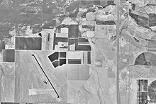 |
| The asphalt (dark black) runway and the dirt (white) runway of Beaver Municipal Airport (left). |
| IATA: none – ICAO: none – FAA LID: U52 |
| Summary |
| Airport type |
Public |
| Owner/Operator |
City of Beaver |
| Location |
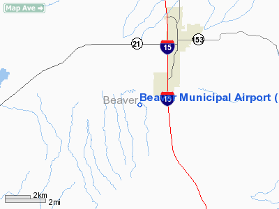
Beaver, Utah |
| Elevation AMSL |
5863 ft / 1787 m |
| Coordinates |
38°13′50.1″N 112°40′31.5″W / 38.230583°N 112.675417°W / 38.230583; -112.675417Coordinates: 38°13′50.1″N 112°40′31.5″W / 38.230583°N 112.675417°W / 38.230583; -112.675417 |
| Website |
beaverutah.net |
| Runways |
| Direction |
Length |
Surface |
| ft |
m |
| 7/25 |
2150 |
655 |
Dirt |
| 13/31 |
4984 |
1519 |
Asphalt |
| Statistics (2007) |
| Airport operations |
3,718 |
| Sources: FAA |
Beaver Municipal Airport (FAA LID: U52) is a public airport in the city of Beaver, Utah. The airport was opened in May 1944 and is owned by the city of Beaver.
In 1992, the airport received federal funding to extend and rehabilitate their runway as well as install a visual approach system. A fence, to keep both wildlife and unauthorized people out of the airport grounds, was funded in 2007.
The above content comes from Wikipedia and is published under free licenses – click here to read more.
Location & QuickFacts
| FAA Information Effective: | 2008-09-25 |
| Airport Identifier: | U52 |
| Airport Status: | Operational |
| Longitude/Latitude: | 112-40-31.5000W/38-13-50.1000N
-112.675417/38.230583 (Estimated) |
| Elevation: | 5863 ft / 1787.04 m (Surveyed) |
| Land: | 841 acres |
| From nearest city: | 4 nautical miles SW of Beaver, UT |
| Location: | Beaver County, UT |
| Magnetic Variation: | 14E (1985) |
Owner & Manager
| Ownership: | Publicly owned |
| Owner: | Beaver City |
| Address: | Po Box 271
Beaver, UT 84713 |
| Phone number: | 435-438-2451 |
| Manager: | Steve Atkin |
| Address: | 60 West Center, Po Box 271
Beaver, UT 84713 |
| Phone number: | 435-438-2451 |
Airport Operations and Facilities
| Airport Use: | Open to public |
| Wind indicator: | Yes |
| Segmented Circle: | Yes |
| Control Tower: | No |
| Lighting Schedule: | DUSK-DAWN
ACTVT MIRL RY 13/31, REIL & PAPI RYS 13 & 31 - CTAF. |
| Beacon Color: | Clear-Green (lighted land airport) |
| Landing fee charge: | No |
| Sectional chart: | Las Vegas |
| Region: | ANM - Northwest Mountain |
| Boundary ARTCC: | ZLC - Salt Lake City |
| Tie-in FSS: | CDC - Cedar City |
| FSS on Airport: | No |
| FSS Toll Free: | 1-800-WX-BRIEF |
| NOTAMs Facility: | CDC (NOTAM-d service avaliable) |
| Federal Agreements: | NGSY |
Airport Communications
Airport Services
| Fuel available: | 100LL
FUEL AVAILABLE 24 HOURS, SELF SERVICE CREDIT CARD SYSTEM. |
| Airframe Repair: | NONE |
| Power Plant Repair: | NONE |
| Bottled Oxygen: | NONE |
| Bulk Oxygen: | NONE |
Runway Information
Runway 07/25
| Dimension: | 2150 x 50 ft / 655.3 x 15.2 m |
| Surface: | DIRT, Fair Condition |
| |
Runway 07 |
Runway 25 |
| Longitude: | 112-40-50.3990W | 112-40-23.4932W |
| Latitude: | 38-13-39.8503N | 38-13-40.9934N |
| Elevation: | 5842.00 ft | 5844.00 ft |
| Alignment: | 87 | 127 |
| Traffic Pattern: | Left | Left |
| Obstruction: | 5 ft gnd, 180.0 ft from runway, 36:1 slope to clear | , 50:1 slope to clear |
|
Runway 13/31
| Dimension: | 4984 x 75 ft / 1519.1 x 22.9 m |
| Surface: | ASPH, Fair Condition |
| Weight Limit: | Single wheel: 12500 lbs. |
| Edge Lights: | Medium |
| |
Runway 13 |
Runway 31 |
| Longitude: | 112-40-45.7753W | 112-40-12.4771W |
| Latitude: | 38-14-15.1378N | 38-13-33.4802N |
| Elevation: | 5791.00 ft | 5863.00 ft |
| Alignment: | 127 | 127 |
| Traffic Pattern: | Left | Left |
| Markings: | Non-precision instrument, Fair Condition | Non-precision instrument, Fair Condition |
| Crossing Height: | 40.00 ft | 59.00 ft |
| VASI: | 2-light PAPI on left side | 2-light PAPI on right side |
| Visual Glide Angle: | 3.00° | 4.00° |
| Runway End Identifier: | Yes | Yes |
| Obstruction: | 10 ft road, 468.0 ft from runway, 26:1 slope to clear
APCH SLOPE 50:1 TO DSPLCD THR. | , 50:1 slope to clear |
|
Radio Navigation Aids
| ID |
Type |
Name |
Ch |
Freq |
Var |
Dist |
| CDC | VOR/DME | Cedar City | 120X | 117.30 | 16E | 32.5 nm |
| MLF | VORTAC | Milford | 058X | 112.10 | 16E | 17.7 nm |
| BCE | VORTAC | Bryce Canyon | 075X | 112.80 | 15E | 37.0 nm |
Remarks
- BIRDS IN VICINITY OF AIRPORT.
Images and information placed above are from
http://www.airport-data.com/airport/U52/
We thank them for the data!
| General Info
|
| Country |
United States
|
| State |
UTAH
|
| FAA ID |
U52
|
| Latitude |
38-13-50.556N
|
| Longitude |
112-40-31.259W
|
| Elevation |
5860 feet
|
| Near City |
BEAVER
|
We don't guarantee the information is fresh and accurate. The data may
be wrong or outdated.
For more up-to-date information please refer to other sources.
|
|


