 |
|
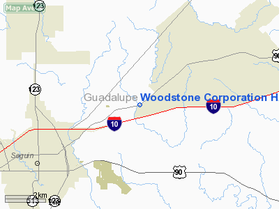
Woodstone Corporation Heliport |
Location & QuickFacts
| FAA Information Effective: | 2008-09-25 |
| Airport Identifier: | XA82 |
| Airport Status: | Operational |
| Longitude/Latitude: | 097-52-54.0000W/29-37-00.0000N
-97.881667/29.616667 (Estimated) |
| Elevation: | 460 ft / 140.21 m (Estimated) |
| Land: | 10 acres |
| From nearest city: | 4 nautical miles NE of Seguin, TX |
| Location: | Guadalupe County, TX |
| Magnetic Variation: | () |
Owner & Manager
| Ownership: | Privately owned |
| Owner: | Woodstone Corp |
| Address: | 6140 E Hwy 90
Seguin, TX 78155 |
| Phone number: | 830-379-0757 |
| Manager: | Benny Hastings |
| Address: | 6140 E. Hwy 90
Seguin, TX 78155 |
| Phone number: | 830-379-0757 |
Airport Operations and Facilities
| Airport Use: | Private |
| Control Tower: | No |
| Sectional chart: | San Antonio |
| Region: | ASW - Southwest |
| Boundary ARTCC: | ZHU - Houston |
| Tie-in FSS: | SJT - San Angelo |
| FSS Toll Free: | 1-800-WX-BRIEF |
Runway Information
Helipad H1
| Dimension: | 20 x 20 ft / 6.1 x 6.1 m |
| Surface: | CONC, |
| |
Runway H1 |
Runway |
| Traffic Pattern: | Left | Left |
|
Radio Navigation Aids
| ID |
Type |
Name |
Ch |
Freq |
Var |
Dist |
| OKT | NDB | Yoakum | | 350.00 | 06E | 43.0 nm |
| DHK | TACAN | Randolph | 036X | | 09E | 20.7 nm |
| KSY | TACAN | Kelly | 057X | | 07E | 39.0 nm |
| SSF | VOR | Stinson | | 108.40 | 09E | 36.5 nm |
| RND | VORTAC | Randolph | 70X | 112.30 | 09E | 21.9 nm |
| SAT | VORTAC | San Antonio | 115X | 116.80 | 08E | 30.3 nm |
| CWK | VORTAC | Centex | 075X | 112.80 | 06E | 49.3 nm |
| SAT | VOT | San Antonio Intl | | 110.40 | | 31.2 nm |
Images and information placed above are from
http://www.airport-data.com/airport/XA82/
We thank them for the data!
|
|


