 |
|
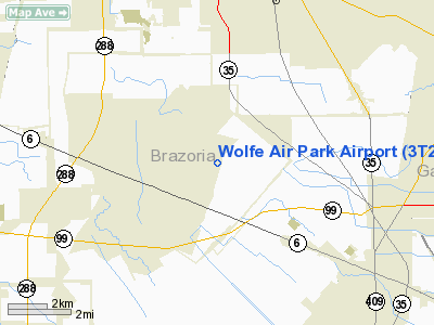
Location & QuickFacts
| FAA Information Effective: | 2008-09-25 |
| Airport Identifier: | 3T2 |
| Airport Status: | Operational |
| Longitude/Latitude: | 095-19-37.7740W/29-28-47.8490N
-95.327159/29.479958 (Estimated) |
| Elevation: | 55 ft / 16.76 m (Estimated) |
| Land: | 125 acres |
| From nearest city: | 2 nautical miles NE of Manvel, TX |
| Location: | Brazoria County, TX |
| Magnetic Variation: | 06E (1985) |
Owner & Manager
| Ownership: | Privately owned |
| Owner: | Wolfe Airpark Civic Club, Inc. |
| Address: | Po Box 1291
Friendswood, TX 77545-1291 |
| Phone number: | 979-234-7707 |
| Manager: | W. J. Bonefas |
| Address: | 8802 Belcher
Manvel, TX 77578 |
| Phone number: | 979-234-7707 |
Airport Operations and Facilities
| Airport Use: | Open to public |
| Wind indicator: | Yes |
| Segmented Circle: | No |
| Control Tower: | No |
| Lighting Schedule: | RDO-CTL
ACTVT LIRL RY 02/20 - CTAF. |
| Landing fee charge: | No |
| Sectional chart: | Houston |
| Region: | ASW - Southwest |
| Boundary ARTCC: | ZHU - Houston |
| Tie-in FSS: | CXO - Montgomery County |
| FSS on Airport: | No |
| FSS Toll Free: | 1-800-WX-BRIEF
FOR FP FILING CALL CXO FSS 1-800-992-7433. |
| NOTAMs Facility: | CXO (NOTAM-d service avaliable) |
Airport Communications
Airport Services
Runway Information
Runway 02/20
| Dimension: | 2910 x 80 ft / 887.0 x 24.4 m
FIRST 100 FT OF RY UNUSABLE AT EACH END DURG WET WEATHER. |
| Surface: | TURF, Good Condition |
| Edge Lights: | Non-standard lighting system
NSTD LIRL; 4 NSTD THLD LGTS DENOTE RY END DURG NIGHT OPNS. LIGHTING FOR RY 02 87 FT FM ACTUAL THLD & 120 FT FM ACTUAL THLD FOR RY 20. |
| |
Runway 02 |
Runway 20 |
| Traffic Pattern: | Left | Left |
| Obstruction: | 15 ft trees, 35 ft left of centerline | 15 ft road, 195.0 ft from runway, 14:1 slope to clear |
|
Radio Navigation Aids
| ID |
Type |
Name |
Ch |
Freq |
Var |
Dist |
| SYG | NDB | Sandy Point | | 402.00 | 05E | 7.5 nm |
| JPA | NDB | Sanjac | | 347.00 | 05E | 17.6 nm |
| SGR | NDB | Hull | | 388.00 | 05E | 19.5 nm |
| LYD | NDB | Lakeside | | 249.00 | 05E | 27.3 nm |
| GLS | NDB | Galveston | | 206.00 | 08E | 31.2 nm |
| BVP | NDB | Nixin | | 326.00 | 05E | 31.4 nm |
| EYQ | NDB | Weiser | | 286.00 | 06E | 31.8 nm |
| CBC | NDB | Anahuac | | 413.00 | 05E | 38.9 nm |
| DWH | NDB | David Hooks | | 521.00 | 05E | 40.8 nm |
| BYY | NDB | Bay City | | 344.00 | 06E | 41.3 nm |
| ARM | NDB | Wharton | | 245.00 | 06E | 45.3 nm |
| EFD | TACAN | Ellington | 031X | | 05E | 11.6 nm |
| HUB | VOR/DME | Hobby | 118X | 117.10 | 05E | 10.9 nm |
| MHF | VOR/DME | Trinity | 083X | 113.60 | 07E | 30.6 nm |
| VUH | VORTAC | Scholes | 077X | 113.00 | 06E | 27.2 nm |
| IAH | VORTAC | Humble | 113X | 116.60 | 05E | 28.7 nm |
| HOU | VOT | Houston Wm P Hobby | | 108.40 | | 10.2 nm |
Remarks
- FISHER AERO SERVICES 281-639-9161.
- 4 FT FENCE CROSSING RY 02 THLD.
- DITCH CROSSING RY 20 THLD.
Images and information placed above are from
http://www.airport-data.com/airport/3T2/
We thank them for the data!
| General Info
|
| Country |
United States
|
| State |
TEXAS
|
| FAA ID |
3T2
|
| Latitude |
29-28-47.849N
|
| Longitude |
095-19-37.774W
|
| Elevation |
55 feet
|
| Near City |
MANVEL
|
We don't guarantee the information is fresh and accurate. The data may
be wrong or outdated.
For more up-to-date information please refer to other sources.
|
|


