 |
|
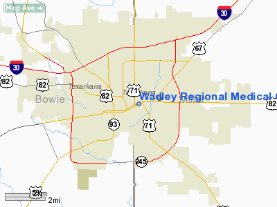
Wadley Rgnl Medical Center Heliport |
Location & QuickFacts
| FAA Information Effective: | 2008-09-25 |
| Airport Identifier: | 64XS |
| Airport Status: | Operational |
| Longitude/Latitude: | 094-02-20.6680W/33-25-45.5570N
-94.039074/33.429321 (Estimated) |
| Elevation: | 347 ft / 105.77 m (Estimated) |
| Land: | 0 acres |
| From nearest city: | 0 nautical miles N of Texarkana, TX |
| Location: | Bowie County, TX |
| Magnetic Variation: | 05E (1985) |
Owner & Manager
| Ownership: | Privately owned |
| Owner: | Wadley Rgnl Medical Cntr |
| Address: | 1000 Pine St
Texarkana, TX 75501 |
| Phone number: | 903-798-8000 |
| Manager: | Hugh Hallgren |
| Address: | 1000 Pine St
Texarkana, TX 75501 |
| Phone number: | 903-798-8000 |
Airport Operations and Facilities
| Airport Use: | Private
MEDICAL. |
| Wind indicator: | Yes |
| Segmented Circle: | No |
| Control Tower: | No |
| Lighting Schedule: | PHONE REQ
FOR ROTG BCN & PERIMETER LGTS CALL 903-798-8000. |
| Beacon Color: | Clear-Green-Yellow (heliport) |
| Sectional chart: | Memphis |
| Region: | ASW - Southwest |
| Boundary ARTCC: | ZFW - Fort Worth |
| Tie-in FSS: | FTW - Fort Worth |
| FSS on Airport: | No |
| FSS Phone: | 817-541-3474 |
| FSS Toll Free: | 1-800-WX-BRIEF |
Runway Information
Helipad H1
| Dimension: | 50 x 50 ft / 15.2 x 15.2 m |
| Surface: | CONC,
HELIPAD LOCATED ON 4TH FLOOR ROOF. |
| |
Runway H1 |
Runway |
| Traffic Pattern: | Left | Left |
| Markings: | Basic, Good Condition
MKD WITH RED 'H' IN THE CENTER OF WHITE CROSS. | ,
MKD WITH RED 'H' IN THE CENTER OF WHITE CROSS. |
|
Radio Navigation Aids
| ID |
Type |
Name |
Ch |
Freq |
Var |
Dist |
| ATA | NDB | Atlanta | | 347.00 | 04E | 21.0 nm |
| HPC | NDB | Hope | | 362.00 | 03E | 26.1 nm |
| VIV | NDB | Vivian | | 284.00 | 06E | 34.3 nm |
| DEQ | NDB | De Queen | | 281.00 | 04E | 41.2 nm |
| AGO | NDB | Magnolia | | 266.00 | 04E | 43.1 nm |
| SPH | NDB | Springhill | | 375.00 | 05E | 44.0 nm |
| LST | NDB | Lone Star | | 305.00 | 05E | 46.5 nm |
| IBO | NDB | Idabel | | 271.00 | 03E | 49.4 nm |
| TXK | VORTAC | Texarkana | 110X | 116.30 | 07E | 5.4 nm |
| EIC | VORTAC | Belcher | 121X | 117.40 | 07E | 41.2 nm |
Remarks
- PPR FOR LNDGS PHONE 903-798-8000 EXT 2831 OR RDO 155.340.
Images and information placed above are from
http://www.airport-data.com/airport/64XS/
We thank them for the data!
| General Info
|
| Country |
United States
|
| State |
TEXAS
|
| FAA ID |
64XS
|
| Latitude |
32-25-45.557N
|
| Longitude |
094-02-20.668W
|
| Elevation |
347 feet
|
| Near City |
TEXARKANA
|
We don't guarantee the information is fresh and accurate. The data may
be wrong or outdated.
For more up-to-date information please refer to other sources.
|
|


