 |
|
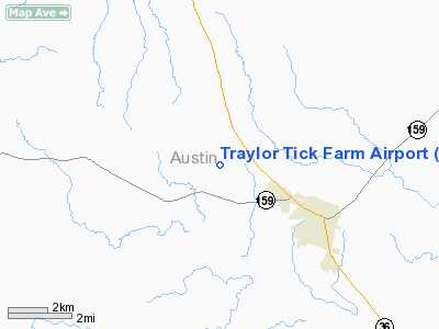
Traylor Tick Farm Airport |
Location & QuickFacts
| FAA Information Effective: | 2008-09-25 |
| Airport Identifier: | 61TX |
| Airport Status: | Operational |
| Longitude/Latitude: | 096-18-25.8730W/29-58-20.8070N
-96.307187/29.972446 (Estimated) |
| Elevation: | 250 ft / 76.20 m (Estimated) |
| Land: | 0 acres |
| From nearest city: | 3 nautical miles NW of Bellville, TX |
| Location: | Austin County, TX |
| Magnetic Variation: | 06E (1985) |
Owner & Manager
| Ownership: | Privately owned |
| Owner: | Thomas M Traylor |
| Address: | Po Box 804
Belleville, TX 77418 |
| Phone number: | 409-865-9607 |
| Manager: | Thomas M Traylor
SPECIALIZED DISTRIBUTING |
| Address: | Po Box 804
Belleville, TX 77418 |
| Phone number: | 713-928-3707 |
Airport Operations and Facilities
| Airport Use: | Private |
| Wind indicator: | Yes |
| Segmented Circle: | No |
| Control Tower: | No |
| Landing fee charge: | No |
| Sectional chart: | Houston |
| Region: | ASW - Southwest |
| Boundary ARTCC: | ZHU - Houston |
| Tie-in FSS: | CXO - Montgomery County |
| FSS on Airport: | No |
| FSS Toll Free: | 1-800-WX-BRIEF
FOR FP FILING CALL CXO FSS 1-800-833-5602. |
Runway Information
Runway 02/20
| Dimension: | 1800 x 80 ft / 548.6 x 24.4 m |
| Surface: | TURF, |
| |
Runway 02 |
Runway 20 |
| Traffic Pattern: | Left | Left |
|
Radio Navigation Aids
| ID |
Type |
Name |
Ch |
Freq |
Var |
Dist |
| BNH | NDB | Brenham | | 362.00 | 06E | 15.4 nm |
| LYD | NDB | Lakeside | | 249.00 | 05E | 34.1 nm |
| EYQ | NDB | Weiser | | 286.00 | 06E | 34.8 nm |
| GYB | NDB | Lee County | | 385.00 | 07E | 36.9 nm |
| SGR | NDB | Hull | | 388.00 | 05E | 39.6 nm |
| DWH | NDB | David Hooks | | 521.00 | 05E | 39.7 nm |
| ARM | NDB | Wharton | | 245.00 | 06E | 43.9 nm |
| ELA | VOR/DME | Eagle Lake | 111X | 116.40 | 08E | 18.6 nm |
| IDU | VORTAC | Industry | 039X | 110.20 | 08E | 13.3 nm |
| TNV | VORTAC | Navasota | 106X | 115.90 | 08E | 23.0 nm |
| CLL | VORTAC | College Station | 080X | 113.30 | 08E | 38.5 nm |
Remarks
- ON THE CONDITION YOU PROVIDE A CLEARED 20:1 APCH TO RWY 20 THR; VFR OPNS ONLY.
Images and information placed above are from
http://www.airport-data.com/airport/61TX/
We thank them for the data!
| General Info
|
| Country |
United States
|
| State |
TEXAS
|
| FAA ID |
61TX
|
| Latitude |
29-58-20.807N
|
| Longitude |
096-18-25.873W
|
| Elevation |
250 feet
|
| Near City |
BELLVILLE
|
We don't guarantee the information is fresh and accurate. The data may
be wrong or outdated.
For more up-to-date information please refer to other sources.
|
|


