 |
|
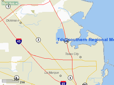
Tdcj/southern Rgnl Medical Facility Heliport |
Location & QuickFacts
| FAA Information Effective: | 2008-09-25 |
| Airport Identifier: | 43XS |
| Airport Status: | Operational |
| Longitude/Latitude: | 094-58-51.7300W/29-25-32.8400N
-94.981036/29.425789 (Estimated) |
| Elevation: | 10 ft / 3.05 m (Estimated) |
| Land: | 0 acres |
| From nearest city: | 6 nautical miles NW of Texas City, TX |
| Location: | Galveston County, TX |
| Magnetic Variation: | 05E (1995) |
Owner & Manager
| Ownership: | Publicly owned |
| Owner: | Tx Dept Of Criminal Justice |
| Address: | Po Box 99
Huntsville, TX 77342-0099 |
| Phone number: | 409-294-2169 |
| Manager: | Gary Johnson |
| Address: | Po Box 99
Huntsville, TX 77342-0099 |
| Phone number: | 409-294-2169 |
Airport Operations and Facilities
| Airport Use: | Private
MEDICAL. |
| Wind indicator: | Yes |
| Segmented Circle: | Yes |
| Control Tower: | No |
| Lighting Schedule: | PHONE REQ
FOR PERIMETER LGTS CALL 409-294-2169. |
| Sectional chart: | Houston |
| Region: | ASW - Southwest |
| Boundary ARTCC: | ZHU - Houston |
| Tie-in FSS: | CXO - Montgomery County |
| FSS on Airport: | No |
| FSS Toll Free: | 1-800-WX-BRIEF |
Runway Information
Helipad H1
| Dimension: | 30 x 30 ft / 9.1 x 9.1 m |
| Surface: | CONC, |
| |
Runway H1 |
Runway |
| Traffic Pattern: | Left | Left |
|
Radio Navigation Aids
| ID |
Type |
Name |
Ch |
Freq |
Var |
Dist |
| GLS | NDB | Galveston | | 206.00 | 08E | 13.0 nm |
| JPA | NDB | Sanjac | | 347.00 | 05E | 15.3 nm |
| SYG | NDB | Sandy Point | | 402.00 | 05E | 25.9 nm |
| CBC | NDB | Anahuac | | 413.00 | 05E | 26.7 nm |
| BVP | NDB | Nixin | | 326.00 | 05E | 36.2 nm |
| SGR | NDB | Hull | | 388.00 | 05E | 37.4 nm |
| LYD | NDB | Lakeside | | 249.00 | 05E | 43.3 nm |
| EYQ | NDB | Weiser | | 286.00 | 06E | 46.0 nm |
| EFD | TACAN | Ellington | 031X | | 05E | 14.3 nm |
| MHF | VOR/DME | Trinity | 083X | 113.60 | 07E | 14.2 nm |
| HUB | VOR/DME | Hobby | 118X | 117.10 | 05E | 20.7 nm |
| VUH | VORTAC | Scholes | 077X | 113.00 | 06E | 11.1 nm |
| IAH | VORTAC | Humble | 113X | 116.60 | 05E | 37.2 nm |
| DAS | VORTAC | Daisetta | 116X | 116.90 | 05E | 49.1 nm |
| HOU | VOT | Houston Wm P Hobby | | 108.40 | | 20.4 nm |
Images and information placed above are from
http://www.airport-data.com/airport/43XS/
We thank them for the data!
| General Info
|
| Country |
United States
|
| State |
TEXAS
|
| FAA ID |
43XS
|
| Latitude |
29-25-32.840N
|
| Longitude |
094-58-51.730W
|
| Elevation |
10 feet
|
| Near City |
TEXAS CITY
|
We don't guarantee the information is fresh and accurate. The data may
be wrong or outdated.
For more up-to-date information please refer to other sources.
|
|


