 |
|
Location & QuickFacts
| FAA Information Effective: | 2008-09-25 |
| Airport Identifier: | 4TA9 |
| Airport Status: | Operational |
| Longitude/Latitude: | 095-46-09.8190W/29-37-38.8460N
-95.769394/29.627457 (Estimated) |
| Elevation: | 88 ft / 26.82 m (Estimated) |
| Land: | 0 acres |
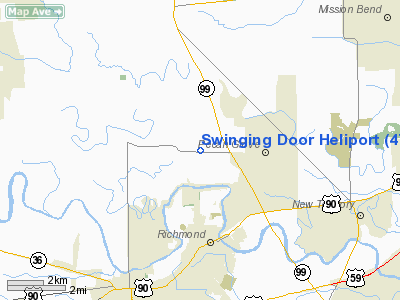
| From nearest city: | 3 nautical miles N of Richmond, TX |
| Location: | Fort Bend County, TX |
| Magnetic Variation: | 06E (1985) |
Owner & Manager
| Ownership: | Privately owned |
| Owner: | Ward K. Onstad |
| Address: | 3714 Fm 359
Richmond, TX 77469 |
| Phone number: | 713-342-4758 |
| Manager: | Steve Onstad |
| Address: | 3714 Fm 359
Richmond, TX 77469 |
| Phone number: | 713-342-4758 |
Airport Operations and Facilities
| Airport Use: | Private |
| Wind indicator: | Yes |
| Segmented Circle: | No |
| Control Tower: | No |
| Lighting Schedule: | PHONE REQ
FOR PERIMETER LIGHTS CALL 713-342-4758. |
| Landing fee charge: | No |
| Sectional chart: | Houston |
| Region: | ASW - Southwest |
| Boundary ARTCC: | ZHU - Houston |
| Tie-in FSS: | CXO - Montgomery County |
| FSS on Airport: | No |
| FSS Toll Free: | 1-800-WX-BRIEF
FOR FP FILING CALL CXO FSS 1-800-833-5602. |
Runway Information
Helipad H1
| Dimension: | 100 x 100 ft / 30.5 x 30.5 m |
| Surface: | TURF, |
| |
Runway H1 |
Runway |
| Traffic Pattern: | Left | Left |
| Obstruction: | 100 ft plines, 200.0 ft from runway
100' PLINES 200' SOUTH. |
100' PLINES 200' SOUTH. |
|
Radio Navigation Aids
| ID |
Type |
Name |
Ch |
Freq |
Var |
Dist |
| SGR | NDB | Hull | | 388.00 | 05E | 5.9 nm |
| LYD | NDB | Lakeside | | 249.00 | 05E | 12.3 nm |
| SYG | NDB | Sandy Point | | 402.00 | 05E | 17.4 nm |
| EYQ | NDB | Weiser | | 286.00 | 06E | 19.6 nm |
| ARM | NDB | Wharton | | 245.00 | 06E | 30.1 nm |
| DWH | NDB | David Hooks | | 521.00 | 05E | 31.8 nm |
| BVP | NDB | Nixin | | 326.00 | 05E | 36.3 nm |
| JPA | NDB | Sanjac | | 347.00 | 05E | 36.6 nm |
| BYY | NDB | Bay City | | 344.00 | 06E | 39.6 nm |
| BNH | NDB | Brenham | | 362.00 | 06E | 47.6 nm |
| EFD | TACAN | Ellington | 031X | | 05E | 31.9 nm |
| HUB | VOR/DME | Hobby | 118X | 117.10 | 05E | 25.8 nm |
| ELA | VOR/DME | Eagle Lake | 111X | 116.40 | 08E | 28.7 nm |
| IAH | VORTAC | Humble | 113X | 116.60 | 05E | 29.7 nm |
| TNV | VORTAC | Navasota | 106X | 115.90 | 08E | 42.5 nm |
| IDU | VORTAC | Industry | 039X | 110.20 | 08E | 45.8 nm |
| HOU | VOT | Houston Wm P Hobby | | 108.40 | | 25.7 nm |
Images and information placed above are from
http://www.airport-data.com/airport/4TA9/
We thank them for the data!
| General Info
|
| Country |
United States
|
| State |
TEXAS
|
| FAA ID |
4TA9
|
| Latitude |
29-37-38.846N
|
| Longitude |
095-46-09.819W
|
| Elevation |
88 feet
|
| Near City |
RICHMOND
|
We don't guarantee the information is fresh and accurate. The data may
be wrong or outdated.
For more up-to-date information please refer to other sources.
|
|


