 |
|
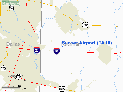
Location & QuickFacts
| FAA Information Effective: | 2008-09-25 |
| Airport Identifier: | TA18 |
| Airport Status: | Operational |
| Longitude/Latitude: | 096-28-45.9530W/32-42-25.4690N
-96.479431/32.707075 (Estimated) |
| Elevation: | 444 ft / 135.33 m (Estimated) |
| Land: | 0 acres |
| From nearest city: | 3 nautical miles S of Forney, TX |
| Location: | Kaufman County, TX |
| Magnetic Variation: | 06E (1985) |
Owner & Manager
| Ownership: | Privately owned |
| Owner: | Keith Kelley |
| Address: | 225 Old Nacogdoches Trail
Forney, TX 75126 |
| Phone number: | 214-552-2073 |
| Manager: | Keith Kelley |
| Address: | 225 Old Nacogdoches Trail
Forney, TX 75126 |
| Phone number: | 214-552-2073 |
Airport Operations and Facilities
| Airport Use: | Private |
| Wind indicator: | Yes |
| Segmented Circle: | No |
| Control Tower: | No |
| Lighting Schedule: | PHONE REQ
FOR LIRL RWY NE/SW CALL 214-552-2073. |
| Landing fee charge: | No |
| Sectional chart: | Dallas-ft Worth |
| Region: | ASW - Southwest |
| Boundary ARTCC: | ZFW - Fort Worth |
| Tie-in FSS: | FTW - Fort Worth |
| FSS on Airport: | No |
| FSS Phone: | 817-541-3474 |
| FSS Toll Free: | 1-800-WX-BRIEF |
Airport Services
| Fuel available: | 100LLMOGAS |
Runway Information
Runway NE/SW
| Dimension: | 2500 x 50 ft / 762.0 x 15.2 m |
| Surface: | TURF, |
| Edge Lights: | Low |
| |
Runway NE |
Runway SW |
| Traffic Pattern: | Left | Left |
|
Radio Navigation Aids
| ID |
Type |
Name |
Ch |
Freq |
Var |
Dist |
| JUG | NDB | Jecca | | 388.00 | 06E | 3.6 nm |
| PQF | NDB | Mesquite | | 248.00 | 06E | 6.6 nm |
| AVZ | NDB | Travis | | 260.00 | 06E | 12.1 nm |
| LNC | NDB | Lancaster | | 239.00 | 06E | 14.5 nm |
| RBD | NDB | Redbird | | 287.00 | 06E | 19.9 nm |
| MII | NDB | Caddo Mills | | 316.00 | 06E | 23.2 nm |
| XQH | NDB | Cedar Hill | | 353.00 | 08E | 26.1 nm |
| SYW | NDB | Cash | | 428.00 | 05E | 26.6 nm |
| CGQ | NDB | Powell | | 344.00 | 06E | 38.7 nm |
| CRS | NDB | Corsicana | | 396.00 | 06E | 41.1 nm |
| AHX | NDB | Athens | | 269.00 | 06E | 46.6 nm |
| CSZ | NDB | Crossroads | | 215.00 | 08E | 46.9 nm |
| LIQ | NDB | Lochridge Ranch | | 335.00 | 09E | 49.7 nm |
| MJF | TACAN | Arvilla | 033X | | 05E | 30.2 nm |
| NFW | TACAN | Nas Jrb Fort Worth | 024X | | 07E | 48.7 nm |
| CVE | VOR/DME | Cowboy | 109X | 116.20 | 06E | 24.1 nm |
| TTT | VOR/DME | Maverick | 078X | 113.10 | 06E | 30.0 nm |
| CQY | VORTAC | Cedar Creek | 095X | 114.80 | 06E | 34.0 nm |
| FUZ | VORTAC | Ranger | 104X | 115.70 | 06E | 37.0 nm |
| DAL | VOT | Dallas Love Field | | 113.30 | | 20.6 nm |
| FTW | VOT | Fort Worth Meacham | | 108.20 | | 44.9 nm |
Remarks
- VFR OPNS PROVIDED LANDING THR IS DSPLCD TO PROVIDE A CLEAR 20:1 APCH SLOPE OVER PLINES LCTD TO THE SW.
Images and information placed above are from
http://www.airport-data.com/airport/TA18/
We thank them for the data!
| General Info
|
| Country |
United States
|
| State |
TEXAS
|
| FAA ID |
TA18
|
| Latitude |
32-42-25.469N
|
| Longitude |
096-28-45.953W
|
| Elevation |
444 feet
|
| Near City |
FORNEY
|
We don't guarantee the information is fresh and accurate. The data may
be wrong or outdated.
For more up-to-date information please refer to other sources.
|
|


